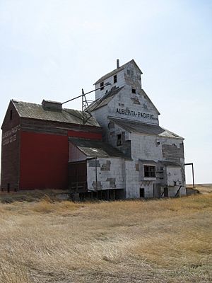
Cardston County facts for kids
Quick facts for kids
Cardston County
|
||
|---|---|---|

Oldest grain elevator in Alberta, located in Raley
|
||
|
||

Location within Alberta
|
||
| Country | Canada | |
| Province | Alberta | |
| Region | Southern Alberta | |
| Census division | 3 | |
| Established | 1954 | |
| Incorporated | 1999 (County) | |
| Area
(2021)
|
||
| • Land | 3,358.39 km2 (1,296.68 sq mi) | |
| Population
(2021)
|
||
| • Total | 4,856 | |
| • Density | 1.4/km2 (4/sq mi) | |
| Time zone | UTC−7 (MST) | |
| • Summer (DST) | UTC−6 (MDT) | |
Cardston County is a special type of local government area, called a municipal district, located in southern Alberta, Canada. It's found in Census Division 3, surrounding the Town of Cardston.
This area was first created on January 1, 1954. It was formed by joining two smaller districts. Later, on January 1, 2000, its name was officially changed to Cardston County.
Contents
Exploring Cardston County's Landscape
Cardston County is in southern Alberta, Canada. It has many different types of land. You can see flat plains and amazing mountain views. The Waterton River flows through the area. This river helps make the farmland very rich and the scenery beautiful.
Lakes in the Area
- Payne Lake is a notable lake found in Cardston County.
Towns and Villages in Cardston County
Cardston County is home to several communities. Some are towns and villages that are surrounded by the county. Other smaller communities, called hamlets and localities, are located right within the county's borders.
Major Urban Areas
These larger communities are surrounded by Cardston County:
- Towns
- Villages
Smaller Communities (Hamlets)
These hamlets are part of Cardston County:
- Aetna
- Beazer
- Carway
- Del Bonita
- Kimball
- Leavitt
- Mountain View
- Spring Coulee
- Welling
- Welling Station
- Woolford
Other Localities
These are even smaller places within Cardston County:
- Boundary Creek
- Bradshaw
- Caldwell
- Colles
- Glenwoodville
- Hacke
- Hartleyville
- Jefferson
- Owendale
- Parkbend
- Raley
- Rush Lake
- Taylorville
- Twin River
- Whiskey Gap
- Woolford Flat
Who Lives in Cardston County?
Every few years, Canada counts its population. This helps us understand how many people live in different areas.
Population in 2021
In 2021, Statistics Canada counted the people in Cardston County.
- The total population was 4,856 people.
- This was a 8.4% increase from 2016.
- There were 1,143 homes where people lived.
- The land area is about 3,358.39 square kilometers.
- This means there were about 1.4 people living per square kilometer.
Population in 2016
In 2016, the population of Cardston County was 4,481 people.
- This was a 7.5% increase from 2011.
- The land area was slightly larger then, at 3,429.82 square kilometers.
 | Toni Morrison |
 | Barack Obama |
 | Martin Luther King Jr. |
 | Ralph Bunche |


