Carway, Alberta facts for kids
Quick facts for kids
Carway
|
|
|---|---|

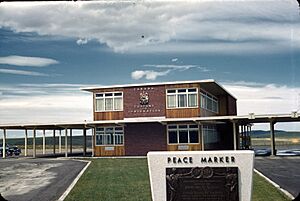
Border crossing in Carway, Alberta
|
|
| Country | Canada |
| Province | Alberta |
| Region | Southern Alberta |
| Census division | 3 |
| Municipal district | Cardston County |
| Government | |
| • Type | Unincorporated |
| Population
(2008)
|
|
| • Total | 2 |
| Time zone | UTC−07:00 (MST) |
| • Summer (DST) | UTC−06:00 (MDT) |
| Area code(s) | 403, 587, 825 |
Carway is a very small community in southern Alberta, Canada. It's called a hamlet, which is like a tiny village. Carway is located within Cardston County.
This hamlet is special because it's a port of entry. This means it's a place where people can cross the border into the U.S. state of Montana. Right across the border from Carway is the town of Piegan, Montana. You'll also find the Blackfeet Indian Reservation nearby in Glacier County, Montana.
Carway is about 23 km (14 mi) south of a town called Cardston. It's at the very end of Highway 2 in Alberta. When you cross the border, this highway becomes U.S. Route 89 in Montana.
The name "Carway" was created by William Roberts. He was the first officer in charge of the border station there. He combined parts of "Cardston" and "highway" to make the name. This kind of combined word is called a portmanteau.
Carway's Weather
Carway has a type of weather called a humid continental climate. This means it has four distinct seasons. Summers are usually mild and can be rainy. Winters are cold and get a lot of snow. On average, Carway receives about 250.4 cm (98.6 in) of snow each year.
The table below shows more details about the weather in Carway throughout the year.
| Climate data for Carway, Alberta | |||||||||||||
|---|---|---|---|---|---|---|---|---|---|---|---|---|---|
| Month | Jan | Feb | Mar | Apr | May | Jun | Jul | Aug | Sep | Oct | Nov | Dec | Year |
| Record high °C (°F) | 16.7 (62.1) |
19.0 (66.2) |
24.4 (75.9) |
29.4 (84.9) |
30.0 (86.0) |
32.8 (91.0) |
38.0 (100.4) |
36.1 (97.0) |
35.0 (95.0) |
30.0 (86.0) |
24.4 (75.9) |
17.8 (64.0) |
38.0 (100.4) |
| Mean daily maximum °C (°F) | 0.8 (33.4) |
1.0 (33.8) |
4.8 (40.6) |
9.9 (49.8) |
15.0 (59.0) |
18.8 (65.8) |
23.6 (74.5) |
23.5 (74.3) |
17.8 (64.0) |
11.5 (52.7) |
4.0 (39.2) |
0.3 (32.5) |
10.9 (51.6) |
| Daily mean °C (°F) | −5.0 (23.0) |
−4.7 (23.5) |
−0.9 (30.4) |
3.9 (39.0) |
8.5 (47.3) |
12.3 (54.1) |
15.9 (60.6) |
15.5 (59.9) |
10.7 (51.3) |
5.2 (41.4) |
−1.5 (29.3) |
−5.2 (22.6) |
4.6 (40.3) |
| Mean daily minimum °C (°F) | −10.9 (12.4) |
−10.6 (12.9) |
−6.6 (20.1) |
−2.2 (28.0) |
2.0 (35.6) |
5.7 (42.3) |
8.1 (46.6) |
7.5 (45.5) |
3.5 (38.3) |
−1.1 (30.0) |
−7.0 (19.4) |
−10.6 (12.9) |
−1.8 (28.8) |
| Record low °C (°F) | −43.3 (−45.9) |
−39.4 (−38.9) |
−36.1 (−33.0) |
−26.7 (−16.1) |
−14.4 (6.1) |
−4.4 (24.1) |
−3.0 (26.6) |
−7.0 (19.4) |
−15.6 (3.9) |
−26.7 (−16.1) |
−34.0 (−29.2) |
−43.9 (−47.0) |
−43.9 (−47.0) |
| Average precipitation mm (inches) | 25.4 (1.00) |
28.6 (1.13) |
45.9 (1.81) |
53.1 (2.09) |
78.5 (3.09) |
92.9 (3.66) |
39.9 (1.57) |
44.0 (1.73) |
51.2 (2.02) |
29.0 (1.14) |
33.9 (1.33) |
27.8 (1.09) |
550.2 (21.66) |
| Average rainfall mm (inches) | 0.0 (0.0) |
0.0 (0.0) |
0.5 (0.02) |
12.1 (0.48) |
59.0 (2.32) |
91.6 (3.61) |
39.9 (1.57) |
42.9 (1.69) |
45.2 (1.78) |
7.2 (0.28) |
0.9 (0.04) |
0.5 (0.02) |
229.8 (9.05) |
| Average snowfall cm (inches) | 25.4 (10.0) |
28.6 (11.3) |
45.4 (17.9) |
40.9 (16.1) |
19.5 (7.7) |
1.3 (0.5) |
0.0 (0.0) |
1.2 (0.5) |
6.0 (2.4) |
21.8 (8.6) |
32.9 (13.0) |
27.4 (10.8) |
250.4 (98.6) |
| Source: Environment Canada | |||||||||||||
How Many People Live in Carway?
According to a count done in 2008 by Cardston County, the population of Carway was 2 people. Yes, just two!
 | Bessie Coleman |
 | Spann Watson |
 | Jill E. Brown |
 | Sherman W. White |


