Flathead County, Montana facts for kids
Quick facts for kids
Flathead County
|
||
|---|---|---|

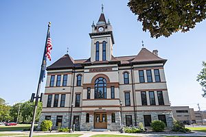
Flathead County Courthouse in Kalispell
|
||
|
||

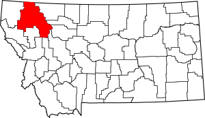
Location within the U.S. state of Montana
|
||
 Montana's location within the U.S. |
||
| Country | ||
| State | ||
| Founded | 1893 | |
| Named for | Flathead Indians | |
| Seat | Kalispell | |
| Largest city | Kalispell | |
| Area | ||
| • Total | 5,256 sq mi (13,610 km2) | |
| • Land | 5,088 sq mi (13,180 km2) | |
| • Water | 169 sq mi (440 km2) 3.2% | |
| Population
(2020)
|
||
| • Total | 104,357 | |
| • Estimate
(2022)
|
111,814 |
|
| • Density | 19.8548/sq mi (7.6660/km2) | |
| Time zone | UTC−7 (Mountain) | |
| • Summer (DST) | UTC−6 (MDT) | |
| Congressional district | 1st | |
|
||
Flathead County is a county in the state of Montana, USA. It is known for its beautiful natural areas. In 2020, about 104,357 people lived here. This makes it the fourth largest county in Montana by population.
The main town, or county seat, of Flathead County is Kalispell. The number 7 is used on license plates from this county. Flathead County is located in northern Montana. Its northern edge touches the border with Canada, next to British Columbia. The county is also part of the Kalispell, Montana Micropolitan Statistical Area.
Contents
History of Flathead County
Flathead County was officially created in 1893. The county was named after the Flathead Indians. Some stories suggest the name came from a practice of flattening infants' heads. However, there is no proof that the Salish tribe, often called Flathead, ever did this.
Geography and Natural Wonders
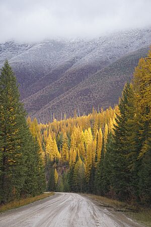
Flathead County is home to many amazing natural features. These include a large part of Flathead Lake, the wide Flathead Valley, and the Flathead River. These places were formed by glaciers. This glacial activity ended about 10,000 years ago.
The Flathead Valley is the southern end of a huge valley. This valley is called the Rocky Mountain Trench. It stretches all the way from Canada's Yukon Territory down to Flathead Lake. Glaciers flowing from British Columbia helped shape this area. They left behind a flat valley floor. They also created a natural dam for the Flathead River. This dam formed Flathead Lake.
Several Native American tribes have used Flathead Lake for a long time. Today, the Bitterroot Salish, Kootenai, and Pend d'Oreilles tribes live on the nearby Flathead Reservation. A large part of Glacier National Park is also located within Flathead County.
Size of the County
Flathead County covers a total area of about 5,256 square miles. Of this, 5,088 square miles are land. The remaining 169 square miles (about 3.2%) are water. It is the third largest county in Montana by land area. It is the second largest by total area.
Wildlife and Ecology
Flathead County is home to many different animals. You might see bobcats, black bears, and coyotes. There are also deer, elk, and grizzly bears. Other animals include lynx, mountain lions, and wolves.
Protected Natural Areas
Flathead County contains parts of several important protected areas. These areas help keep the natural environment safe.
- Pacific Northwest National Scenic Trail (a long hiking trail)
- Flathead National Forest (a large forest)
- Glacier National Park (a famous national park)
- Kootenai National Forest (another large forest)
- Lolo National Forest (part of a big forest)
- Lost Trail National Wildlife Refuge (a place for wildlife)
Population and People
Flathead County has grown a lot over the years. Here's how the population has changed:
| Historical population | |||
|---|---|---|---|
| Census | Pop. | %± | |
| 1900 | 9,375 | — | |
| 1910 | 14,079 | 50.2% | |
| 1920 | 21,705 | 54.2% | |
| 1930 | 19,200 | −11.5% | |
| 1940 | 24,271 | 26.4% | |
| 1950 | 31,495 | 29.8% | |
| 1960 | 32,965 | 4.7% | |
| 1970 | 39,460 | 19.7% | |
| 1980 | 51,966 | 31.7% | |
| 1990 | 59,218 | 14.0% | |
| 2000 | 74,471 | 25.8% | |
| 2010 | 90,928 | 22.1% | |
| 2020 | 104,357 | 14.8% | |
| 2022 (est.) | 111,814 | 23.0% | |
| U.S. Decennial Census 1790–1960 1900–1990 1990–2000 2010–2020 |
|||
Population in 2020
In 2020, the census showed that 104,357 people lived in Flathead County.
Population in 2010
According to the 2010 census, there were 90,928 people living in the county. Most people were white (95.5%). About 1.1% were American Indian. People of Hispanic or Latino origin made up 2.3% of the population.
Many people in the county have German (28.1%), English (15.0%), or Irish (14.8%) backgrounds. The average age of people in the county was about 41.2 years old.
Important Services and Buildings
Flathead County has many important services for its residents.
- Kalispell Regional Medical Center is the largest hospital in the county.
- North Valley Hospital is located in Whitefish.
- The Flathead County Library System has four locations:
- Bigfork
- Columbia Falls
- Kalispell
- Marion
- The Whitefish Library is a separate library.
- Flathead County Solid Waste (Landfill) is between Kalispell and Whitefish.
- There are 16 Fire Districts and 3 Fire Service Areas.
- The county has 6 high schools, including private ones.
- There are 21 Public School Districts.
Communities in Flathead County
Flathead County has several towns and cities.
Cities
- Columbia Falls
- Kalispell (the county seat)
- Whitefish
Census-designated places
These are areas that are like towns but are not officially incorporated as cities.
- Batavia
- Bigfork
- Coram
- Essex
- Evergreen
- Forest Hill Village
- Helena Flats
- Hungry Horse
- Kila
- Lakeside
- Little Bitterroot Lake
- Marion
- Martin City
- Niarada
- Olney
- Pinnacle
- Polebridge
- Rhodes
- Snowslip
- Somers
- West Glacier
Other unincorporated communities
These are smaller communities that are not officially part of a city or census-designated place.
- Apgar Village
- Lake McDonald
Neighboring Counties and Regions
Flathead County shares borders with several other counties and regions.
- Regional District of East Kootenay, British Columbia – to the north
- Waterton Lakes National Park (Improvement District No. 4), Alberta – to the northeast
- Glacier County – to the east
- Pondera County – to the east
- Teton County – to the east
- Lewis and Clark County – to the southeast
- Powell County – to the southeast
- Missoula County – to the southeast
- Lake County – to the south
- Sanders County – to the southwest
- Lincoln County – to the west
Education in Flathead County
The county has many schools for students of all ages.
High School Districts
- Bigfork High School District
- Columbia Falls High School District
- Flathead High School District
- Whitefish High School District
Elementary School Districts
- Bigfork Elementary School District
- Cayuse Prairie Elementary School District
- Columbia Falls Elementary School District
- Creston Elementary School District
- Deer Park Elementary School District
- Fair-Mont-Egan Elementary School District
- Evergreen Elementary School District
- Helena Flats Elementary School District
- Kalispell Elementary School District
- Kila Elementary School District
- Marion Elementary School District
- Olney-Bissell Elementary School District
- Pleasant Valley Elementary School District
- Smith Valley Elementary School District
- Somers Elementary School District
- Swan River Elementary School District
- West Glacier Elementary School District
- West Valley Elementary School District
- Whitefish Elementary School District
Higher Education
Flathead Valley Community College is a college in the area. It offers many different programs for students after high school.
Famous People from Flathead County
Several well-known people have connections to Flathead County.
- Joe Bereta, a comedian and YouTube host.
- Phil Jackson, a famous NBA coach and player.
- Dorothy M. Johnson, a writer known for Western stories.
- Maury Povich, a popular talk show host.
- Keith Regier, a Montana state senator.
- Alice Ritzman, a professional golf player (LPGA).
- Derek Skees, a Montana state representative.
- Michelle Williams, an actress.
See also
 In Spanish: Condado de Flathead para niños
 | Leon Lynch |
 | Milton P. Webster |
 | Ferdinand Smith |


