Kalispell, Montana facts for kids
Quick facts for kids
Kalispell, Montana
Ql̓ispé
Kqayaqawakⱡuʔnam |
|
|---|---|
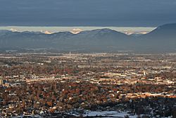
Kalispell looking northeast toward Glacier National Park from Lone Pine State Park
|
|
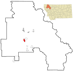
Location of Kalispell within Flathead County
|
|
| Country | United States |
| State | Montana |
| County | Flathead |
| Area | |
| • City | 12.64 sq mi (32.74 km2) |
| • Land | 12.56 sq mi (32.52 km2) |
| • Water | 0.09 sq mi (0.22 km2) |
| Elevation | 3,084 ft (940 m) |
| Population
(2020)
|
|
| • City | 24,558 |
| • Density | 1,955.88/sq mi (755.20/km2) |
| • Metro | 104,357 |
| Time zone | UTC−7 (Mountain (MST)) |
| • Summer (DST) | UTC−6 (MDT) |
| ZIP codes |
59901-59904
|
| Area code(s) | 406 |
| FIPS code | 30-40075 |
| GNIS feature ID | 2410161 |
Kalispell is a city in Montana, United States. It is the main city of Flathead County. In 2020, about 24,558 people lived there. This makes Kalispell one of Montana's largest and fastest-growing cities.
Kalispell is the biggest city in northwest Montana. It is also the main business hub for the area. The name Kalispell comes from a Salish word. It means "flat land above the lake."
Contents
History of Kalispell
How Kalispell Started
The first European to explore the Flathead Valley was likely Peter Fidler in the 1700s. He worked for the Hudson’s Bay Company. Around 1870, people started settling here permanently. They brought livestock, which changed the area.
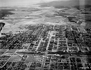
In 1884, a town called Ashley was founded where Kalispell is now. It didn't last long. Three years later, another town called Demersville started nearby. Demersville grew quickly and became the biggest town. But when the Great Northern Railroad decided not to go through Demersville, people moved. They went to the new town of Kalispell instead.
Railroad and City Growth
The Great Northern Railroad was building a line across the country. They needed a main stop in the Flathead Valley. Charles Edward Conrad, a businessman, and others from the railroad started the Kalispell Townsite Company. The town was named after the local native tribe. An extra "L" was added to the name.
Land in the new town was quickly divided and sold in 1891. Kalispell officially became a city in 1892. Charles Conrad built a large mansion there in 1895. The city has continued to grow ever since. Even though the railroad route changed in 1904, Kalispell kept growing.
Kalispell as a Regional Center
Kalispell is the largest city in northwest Montana. It is the county seat and a major business center for Flathead County. The city has a large hospital, Logan Health Medical Center.
The railroad tracks that used to run through downtown Kalispell were removed in 2018. The city bought the land and moved the railroad to a new industrial park. This new park, called Glacier Rail Park, is just north of town.
Kalispell is in the beautiful Flathead Valley. It is about 31 miles (50 km) from Glacier National Park. It's also 22 miles (35 km) from Hungry Horse Dam. If you like to ski, Whitefish Mountain Resort and Blacktail Mountain Ski Area are both about 17 miles (27 km) away. Flathead Lake, the biggest freshwater lake west of the Mississippi River, is only 7 miles (11 km) away. Golfers can enjoy the Buffalo Hill Golf Club.
Local schools teach the Kalispel–Spokane–Flathead language. There are also language programs for adults.
Geography and Climate
The city of Kalispell covers about 11.73 square miles (30.4 square kilometers). Most of this area is land.
Kalispell is located about 7 miles (11 km) north of Flathead Lake. This lake is the largest natural freshwater lake in the western U.S. by surface area.
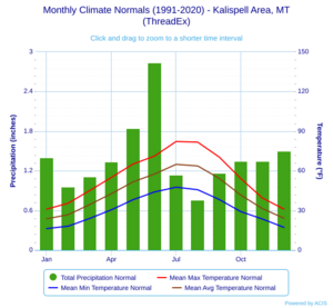
Kalispell has a climate with warm summers and cold, snowy winters. Spring and autumn are short. Snow usually falls from late October or early November until March.
| Climate data for Kalispell, Montana (Glacier Park International Airport), 1991–2020 normals, extremes 1896–present | |||||||||||||
|---|---|---|---|---|---|---|---|---|---|---|---|---|---|
| Month | Jan | Feb | Mar | Apr | May | Jun | Jul | Aug | Sep | Oct | Nov | Dec | Year |
| Record high °F (°C) | 56 (13) |
64 (18) |
73 (23) |
85 (29) |
95 (35) |
102 (39) |
104 (40) |
105 (41) |
99 (37) |
86 (30) |
69 (21) |
62 (17) |
105 (41) |
| Mean maximum °F (°C) | 45.0 (7.2) |
48.3 (9.1) |
60.6 (15.9) |
72.3 (22.4) |
82.3 (27.9) |
86.9 (30.5) |
94.2 (34.6) |
94.5 (34.7) |
86.3 (30.2) |
72.4 (22.4) |
55.7 (13.2) |
45.7 (7.6) |
96.2 (35.7) |
| Mean daily maximum °F (°C) | 31.0 (−0.6) |
35.5 (1.9) |
45.1 (7.3) |
55.0 (12.8) |
65.1 (18.4) |
71.2 (21.8) |
82.2 (27.9) |
81.7 (27.6) |
70.4 (21.3) |
54.1 (12.3) |
39.4 (4.1) |
31.0 (−0.6) |
55.1 (12.8) |
| Daily mean °F (°C) | 23.7 (−4.6) |
26.8 (−2.9) |
34.5 (1.4) |
42.7 (5.9) |
51.6 (10.9) |
57.6 (14.2) |
64.9 (18.3) |
63.7 (17.6) |
54.3 (12.4) |
41.6 (5.3) |
31.4 (−0.3) |
24.1 (−4.4) |
43.1 (6.2) |
| Mean daily minimum °F (°C) | 16.3 (−8.7) |
18.1 (−7.7) |
24.0 (−4.4) |
30.5 (−0.8) |
38.1 (3.4) |
44.0 (6.7) |
47.6 (8.7) |
45.7 (7.6) |
38.3 (3.5) |
29.1 (−1.6) |
23.5 (−4.7) |
17.2 (−8.2) |
31.0 (−0.6) |
| Mean minimum °F (°C) | −8.2 (−22.3) |
−1.6 (−18.7) |
7.7 (−13.5) |
19.8 (−6.8) |
25.6 (−3.6) |
33.0 (0.6) |
37.1 (2.8) |
34.9 (1.6) |
27.1 (−2.7) |
14.5 (−9.7) |
6.7 (−14.1) |
−3.5 (−19.7) |
−15.1 (−26.2) |
| Record low °F (°C) | −38 (−39) |
−36 (−38) |
−29 (−34) |
−5 (−21) |
17 (−8) |
26 (−3) |
30 (−1) |
30 (−1) |
7 (−14) |
−4 (−20) |
−28 (−33) |
−35 (−37) |
−38 (−39) |
| Average precipitation inches (mm) | 1.40 (36) |
0.96 (24) |
1.11 (28) |
1.34 (34) |
1.84 (47) |
2.84 (72) |
1.14 (29) |
0.76 (19) |
1.17 (30) |
1.35 (34) |
1.35 (34) |
1.50 (38) |
16.76 (426) |
| Average snowfall inches (cm) | 13.9 (35) |
8.4 (21) |
5.4 (14) |
1.2 (3.0) |
0.2 (0.51) |
0.3 (0.76) |
0.0 (0.0) |
0.0 (0.0) |
0.0 (0.0) |
1.1 (2.8) |
8.0 (20) |
15.9 (40) |
54.4 (138) |
| Average extreme snow depth inches (cm) | 12.3 (31) |
9.1 (23) |
7.8 (20) |
0.4 (1.0) |
0.0 (0.0) |
0.0 (0.0) |
0.0 (0.0) |
0.0 (0.0) |
0.0 (0.0) |
0.4 (1.0) |
4.2 (11) |
11.1 (28) |
14.8 (38) |
| Average precipitation days (≥ 0.01 in) | 14.2 | 11.4 | 12.4 | 11.3 | 12.0 | 12.7 | 6.7 | 6.4 | 7.6 | 10.5 | 12.2 | 14.3 | 131.7 |
| Average snowy days (≥ 0.1 in) | 10.3 | 8.0 | 4.0 | 1.6 | 0.2 | 0.1 | 0.0 | 0.0 | 0.0 | 0.9 | 5.5 | 10.8 | 41.4 |
| Average relative humidity (%) | 77.6 | 75.8 | 69.2 | 60.2 | 60.6 | 62.6 | 57.5 | 57.8 | 65.0 | 71.9 | 78.5 | 81.1 | 68.2 |
| Average dew point °F (°C) | 15.4 (−9.2) |
19.2 (−7.1) |
23.5 (−4.7) |
28.6 (−1.9) |
36.7 (2.6) |
44.2 (6.8) |
47.1 (8.4) |
45.9 (7.7) |
39.6 (4.2) |
31.8 (−0.1) |
25.0 (−3.9) |
18.0 (−7.8) |
31.3 (−0.4) |
| Source 1: NOAA (relative humidity and dew point 1961–1990) | |||||||||||||
| Source 2: National Weather Service | |||||||||||||
Population of Kalispell
| Historical population | |||
|---|---|---|---|
| Census | Pop. | %± | |
| 1890 | 1,000 | — | |
| 1900 | 2,526 | 152.6% | |
| 1910 | 5,549 | 119.7% | |
| 1920 | 5,147 | −7.2% | |
| 1930 | 6,094 | 18.4% | |
| 1940 | 8,425 | 38.3% | |
| 1950 | 9,737 | 15.6% | |
| 1960 | 10,151 | 4.3% | |
| 1970 | 10,526 | 3.7% | |
| 1980 | 10,648 | 1.2% | |
| 1990 | 11,917 | 11.9% | |
| 2000 | 14,223 | 19.4% | |
| 2010 | 19,927 | 40.1% | |
| 2020 | 24,558 | 23.2% | |
| source: U.S. Decennial Census: 2020 |
|||
In 2010, Kalispell had 19,927 people living there. There were 8,638 households. The average age of people in the city was 34.5 years old. About 25% of the residents were under 18 years old.
Economy and Jobs
Top Employers in Kalispell
Many people in Kalispell work for these companies and organizations:
| Rank | Employer | Number of Employees |
| 1 | Logan Health Medical Center | 1,000+ |
| 2 | Weyerhaeuser (formerly Plum Creek Manufacturing) | 500 to 999 |
| 3 | Health Center Northwest | 250 to 499 |
| 4 | Applied Materials/Semitool | 250 to 499 |
| 5 | TeleTech | 250 to 499 |
| 6 | Glacier Bank | 250 to 499 |
| 7 | Whitefish Mountain Resort | 250 to 499 |
| 8 | Super 1 Foods | 250 to 499 |
| 9 | Walmart | 250 to 499 |
| 10 | Logan Health - Whitefish | 250 to 499 |
Kalispell is also home to the main office of the Montana Rifle Company. As of 2014, one of Montana's last farms that grows peppermint and spearmint is near Kalispell.
Education in Kalispell
Kalispell has its own public school system. It includes both elementary and high schools. There are two high schools in Kalispell: Flathead High School and Glacier High School.
Flathead Valley Community College is a college in the area. Kalispell also has a public library. It is a part of the Flathead County Library system.
Transportation
Kalispell is located where U.S. Routes 2 and 93 meet. You can fly into Glacier Park International Airport. This airport is about 8 miles (13 km) northeast of Kalispell.
The Kalispell City Airport is in the southern part of the city. It is used for smaller planes.
Amtrak's Empire Builder train service is available in Whitefish. Whitefish is about 15 miles (24 km) north of Kalispell. This train goes between Chicago and Seattle or Portland.
Eagle Transit provides local bus service. It connects Kalispell with Columbia Falls and Whitefish.
Media
Kalispell is an important media center in Montana. It has many radio stations and a few television channels.
- AM radio
- KGEZ 600
- KERR 750
- KJJR 880
- KOFI 1180
- KSAM 1240
- KQDE 1340
- FM radio
- KLKM 88.7
- KUKL-FM 90.1
- KFLF 91.3
- KQRK 92.3
- KHNK 95.9
- KALS 97.1
- KBBZ 98.5
- KKMT 99.7
- KIBG 100.7
- KXZI-LP 101.9
- KANB-LP 102.3
- KRVO 103.1
- KZMN 103.9
- KWOL-FM 105.1
- KDBR 106.3
- Television
- Newspapers
- Daily Inter Lake, printed daily and online
- Flathead Beacon, online only
- Montana Senior News, printed in Kalispell, distributed statewide
Notable People
Many interesting people have connections to Kalispell:
- Ruth Anderson, a composer
- Chuck Baldwin, a political candidate
- Brad Bird, an Academy Award-winning director of animated films
- Robert Bray, a film and television actor
- Lily Gladstone, an actress
- Flip Gordon, a professional wrestler
- Robin Lee Graham, who sailed around the world at age 16
- Tanner Hall, a professional skier and X-Games medalist
- Lex Hilliard, a former NFL player
- Dorothy M. Johnson, a famous author of Western stories
- Tim Koleto, an Olympic figure skater
- Brad Ludden, a professional kayaker
- Sam McCullum, a former NFL player
- Brock Osweiler, a former NFL quarterback
- Margaret Qualley, an actress
- Mike Reilly, a CFL quarterback
- Alice Ritzman, a former professional golfer
- Michelle Williams, an actress
See also
 In Spanish: Kalispell para niños
 | John T. Biggers |
 | Thomas Blackshear |
 | Mark Bradford |
 | Beverly Buchanan |


