Teton County, Montana facts for kids
Quick facts for kids
Teton County
|
|
|---|---|

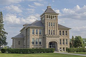
Teton County Courthouse in Choteau
|
|

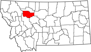
Location within the U.S. state of Montana
|
|
 Montana's location within the U.S. |
|
| Country | |
| State | |
| Founded | 1893 |
| Seat | Choteau |
| Largest city | Choteau |
| Area | |
| • Total | 2,293 sq mi (5,940 km2) |
| • Land | 2,272 sq mi (5,880 km2) |
| • Water | 20 sq mi (50 km2) 0.9% |
| Population
(2020)
|
|
| • Total | 6,226 |
| • Estimate
(2022)
|
6,368 |
| • Density | 2.7152/sq mi (1.04835/km2) |
| Time zone | UTC−7 (Mountain) |
| • Summer (DST) | UTC−6 (MDT) |
| Congressional district | 2nd |
|
|
Teton County is a county located in the state of Montana in the United States. As of the 2020 census, about 6,226 people lived there. The main town and county seat is Choteau. Teton County was started in 1893.
Contents
Exploring Teton County's Geography
Teton County covers a total area of about 2,293 square miles. Most of this area, about 2,272 square miles, is land. The rest, about 20 square miles, is water. This means water makes up less than 1% of the county's total size.
Neighboring Counties
Teton County shares its borders with several other counties. These are its neighbors:
- Pondera County – to the north
- Chouteau County – to the east
- Cascade County – to the southeast
- Lewis and Clark County – to the south
- Flathead County – to the west
Protected Natural Areas
Part of Teton County is home to important natural areas. These places are protected to keep their natural beauty and wildlife safe:
- Lewis and Clark National Forest (part of it is in Teton County)
- Rocky Mountain Front Conservation Area (part of it is in Teton County)
People of Teton County: Demographics
The number of people living in Teton County has changed over the years. Here's a look at how the population has grown and shifted:
| Historical population | |||
|---|---|---|---|
| Census | Pop. | %± | |
| 1900 | 5,080 | — | |
| 1910 | 9,546 | 87.9% | |
| 1920 | 5,870 | −38.5% | |
| 1930 | 6,068 | 3.4% | |
| 1940 | 6,922 | 14.1% | |
| 1950 | 7,232 | 4.5% | |
| 1960 | 7,295 | 0.9% | |
| 1970 | 6,116 | −16.2% | |
| 1980 | 6,491 | 6.1% | |
| 1990 | 6,271 | −3.4% | |
| 2000 | 6,445 | 2.8% | |
| 2010 | 6,073 | −5.8% | |
| 2020 | 6,226 | 2.5% | |
| 2022 (est.) | 6,368 | 4.9% | |
| U.S. Decennial Census 1790–1960 1900–1990 1990–2000 2010–2020 |
|||
Population in 2020
According to the 2020 census, there were 6,226 people living in Teton County.
Population in 2010
In the 2010 census, Teton County had 6,073 people. There were 2,450 households, which are groups of people living together. About 1,643 of these were families.
Most people in the county were white (96.3%). About 1.4% were American Indian. A small number of people were from other backgrounds. About 1.3% of the population was of Hispanic or Latino origin.
Many people in Teton County have German roots (40.2%). Others have Norwegian (14.7%), Irish (14.5%), or English (11.9%) ancestry.
The average age of people in Teton County was 45.8 years old. About 25.7% of households had children under 18 living with them.
Towns and Communities
Teton County has several towns and smaller communities. These are the places where people live and work.
Main City
- Choteau (This is the county seat, meaning it's where the county government is located.)
Smaller Towns
Census-Designated Places
These are areas that are like towns but are not officially incorporated as cities or towns.
Other Communities
These are smaller, unincorporated places in the county.
- Blackleaf
- Collins
- Diamond Valley
- Farmington
- Golden Ridge
- Koyl
- Saypo
Famous People from Teton County
Some notable individuals have connections to Teton County:
- Joe De Yong: An artist, sculptor, and illustrator. He also worked as a technical advisor for Hollywood movies. He lived in Choteau in 1924.
- John Edward Erickson: He was the Teton County Attorney from 1897 to 1905. Later, he became the governor of Montana.
See also
 In Spanish: Condado de Teton (Montana) para niños
 | John T. Biggers |
 | Thomas Blackshear |
 | Mark Bradford |
 | Beverly Buchanan |

