
Lakeside, Montana facts for kids
Quick facts for kids
Lakeside, Montana
|
|
|---|---|

Location of Lakeside, Montana
|
|
| Country | United States |
| State | Montana |
| County | Flathead |
| Area | |
| • Total | 18.0 sq mi (46.5 km2) |
| • Land | 14.1 sq mi (36.4 km2) |
| • Water | 3.9 sq mi (10.1 km2) |
| Elevation | 2,910 ft (887 m) |
| Population
(2010)
|
|
| • Total | 2,669 |
| • Density | 190/sq mi (73.4/km2) |
| Time zone | UTC-7 (Mountain (MST)) |
| • Summer (DST) | UTC-6 (MDT) |
| ZIP code |
59922
|
| Area code(s) | 406 |
| FIPS code | 30-41950 |
| GNIS feature ID | 0785927 |
Lakeside is a community in Flathead County, Montana, United States. It is also known as a census-designated place (CDP). This means it's a special area used for gathering information during a census. In 2010, about 2,669 people lived in Lakeside. This was more than the 1,679 people who lived there in 2000.
Contents
A Town's New Name
Lakeside wasn't always called Lakeside! Back in 1892, the town was known as Stoner. It was named after John J. Stoner, who owned a hotel close to the shores of Flathead Lake.
At that time, there was already another community named Lakeside in Roosevelt County. However, that other town stopped existing in 1920. So, the community of Stoner decided to change its name to Lakeside.
West Shore State Park is a beautiful park located about 5 miles south of Lakeside.
Geography
Where is Lakeside?
Lakeside is located in the southern part of Flathead County. It sits right on the western shore of the northern end of Flathead Lake.
The community of Somers is just north of Lakeside. Lakeside also stretches south all the way to the border of Lake County.
Roads and Travel
U.S. Route 93 is a main road that goes through Lakeside. This road leads north about 14 miles (23 km) to Kalispell. If you go south on Route 93, it's about 37 miles (60 km) to Polson, which is at the very south end of Flathead Lake.
Size of the Area
According to the United States Census Bureau, the Lakeside CDP covers a total area of about 46.5 square kilometers (17.9 square miles). Out of this, 36.4 square kilometers (14.1 square miles) is land, and 10.1 square kilometers (3.9 square miles) is water. This means about 21.69% of Lakeside's area is water.
People of Lakeside
Population Details
In the year 2000, there were 1,679 people living in Lakeside. These people lived in 705 households, and 520 of those were families. The community had about 228.9 people per square mile (88.3 per square kilometer).
There were 956 housing units, which means places where people can live. On average, there were 130.3 housing units per square mile (50.3 per square kilometer).
Households and Families
Out of the 705 households, about 26% had children under 18 years old living with them. Most households, 67.7%, were married couples living together. About 22.7% of all households were made up of people living alone. Also, 9.6% of households had someone aged 65 or older living by themselves.
The average household had about 2.38 people, and the average family had about 2.78 people.
Age Groups
The people in Lakeside were spread out across different age groups. About 23% of the population was under 18 years old. A smaller group, 3.8%, was between 18 and 24 years old. The largest group, 30.3%, was between 45 and 64 years old. About 18.7% of the people were 65 years old or older. The average age in Lakeside was 44 years.
-
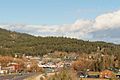
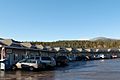
Lakeside seen from the south
-
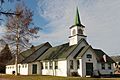
Lakeside Community Chapel
-
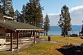
Volunteer Park
-
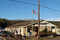
US Post Office
-
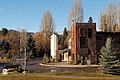
Strip mall with the town's Chamber of Commerce, and Library
-
Tamarack brewery


See also
 In Spanish: Lakeside (Montana) para niños
