
Flathead River facts for kids
Quick facts for kids Flathead River |
|
|---|---|

The river near Perma, Montana
|
|

Map of the Flathead River, its tributary forks and downriver connection to the Columbia River via Clark Fork and the Pend Oreille River
|
|
| Native name | ntx̣ʷetkʷ or ntx̣ʷe (Kalispel-Pend d'Oreille) |
| Country | United States, Canada |
| State | Montana |
| Province | British Columbia |
| Physical characteristics | |
| Main source | Confluence of North Fork and Middle Fork Flathead River Rocky Mountains 3,120 ft (950 m) 48°28′2″N 114°4′10″W / 48.46722°N 114.06944°W |
| River mouth | Clark Fork Montana 2,484 ft (757 m) 47°21′56″N 114°46′34″W / 47.36556°N 114.77611°W |
| Length | 158 mi (254 km) |
| Basin features | |
| Basin size | 8,795 sq mi (22,780 km2) |
| Tributaries | |
| Type: | Wild, Scenic, Recreational |
| Designated: | October 12, 1976 |
The Flathead River is a big river in the northwestern part of Montana, a state in the United States. It starts in the Canadian Rockies, which are mountains north of Glacier National Park.
The river flows southwest into a large body of water called Flathead Lake. After traveling about 158 miles (254 km), it joins the Clark Fork. The Flathead River is part of a bigger river system that eventually leads to the Columbia River.
The Flathead River is the largest river that flows into the Clark Fork. It provides more than half of the water for the Clark Fork. Its drainage basin, which is the area of land where all the water flows into the river, covers about 8,795 square miles (22,779 km²).
Contents
Where the Flathead River Flows
The Flathead River begins with several smaller rivers, called "forks," in the Rocky Mountains of northwestern Montana.
Main Branches of the River
- The North Fork is the largest branch. It flows south from British Columbia, a province in Canada. Many people consider the North Fork to be the main starting point of the Flathead River.
- Near West Glacier, the North Fork joins with the Middle Fork. This is where the main Flathead River officially begins.
- The river then flows west and meets the South Fork. It cuts through a narrow passage called Bad Rock Canyon, located between the Whitefish Range and Swan Range mountains.
All these starting branches of the Flathead River are special. They are part of the National Wild and Scenic Rivers System. This means they are protected for their natural beauty and importance.
Journey Through Flathead Valley
After leaving Bad Rock Canyon, the river enters the wide Flathead Valley. It curves southwest, passing by towns like Columbia Falls and Kalispell.
Later, the Stillwater River and its branch, the Whitefish River, join the Flathead. Finally, the Flathead River flows into Flathead Lake. The Swan River also joins the Flathead River at the lake.
After Flathead Lake
Near Polson, the river leaves Flathead Lake. But first, it flows through the Kerr Dam. This dam helps to keep the water level of Flathead Lake steady.
After the dam, the river turns south. It winds through the Flathead Valley, west of the Mission Mountains. At Dixon, a smaller river called the Jocko River joins it. A few miles later, the Flathead River flows into the Clark Fork near Paradise.
History of the Flathead River Area
People started exploring the Flathead Valley a long time ago. In the early 1800s, Fur traders came to the area. These traders worked for companies like the North West Company and Hudson's Bay Company. They set up trading posts north of Flathead Lake.
The first settlers, who built homes and farms, began to arrive in the 1860s. By the 1880s, people started using irrigation to water their crops. This helped them grow food in the valley.
Fun Activities on the River
The Flathead River is a great place for outdoor fun! In Montana, it's known as a Class I river for recreational access. This means it's easy for people to use for activities.
Many parts of the river are popular for recreation:
- The South Fork of the Flathead, from Youngs Creek to the Hungry Horse reservoir.
- The Middle Fork of the Flathead, from Schaffer Creek to where it meets the main Flathead River.
- The main Flathead River itself, all the way to where it joins the Clark Fork River.
Protecting the Flathead River
The Flathead River is very important, and many parts of it are protected. It is part of the National Wild and Scenic Rivers System. This system helps keep rivers in their natural state.
Protected Areas
- The entire North Fork, from the Canada–US border south, is protected.
- The entire Middle Fork is also protected.
- The South Fork above Hungry Horse Reservoir is protected too.
Working Together for Conservation
The North Fork Flathead River in Montana is a National Wild and Scenic River. However, the part of the river in British Columbia, Canada, doesn't have the same protection. This has caused discussions between the United States and Canada for over 30 years.
In 1988, a group called the International Joint Commission decided that a plan for a coal mine would harm the river. This mine would have gone against a treaty from 1909.
Stopping Threats to the River
For a while, there were plans to develop energy projects on the North Fork. The New York Times newspaper even called it the "wildest river in the continental United States" in 2004.
In 2008, a company called BP announced they would not try to drill for gas in the river's starting areas. This was good news for the river. However, another company still wanted to start a large coal mining project that would remove parts of mountains.
But in 2010, the government of British Columbia made a big announcement. They said they would not allow new mining, oil, or gas projects in their part of the Flathead Valley. This decision was celebrated by environmental groups and U.S. Senators from Montana.
There's also an idea to protect one-third of British Columbia's Flathead River by adding it to the Waterton-Glacier International Peace Park. This park is a special area shared by both countries. In 2003, Parks Canada asked British Columbia to study this idea, but British Columbia has not yet agreed.
Images for kids
-
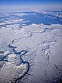
Winter aerial view of the Flathead River below Kerr Dam (below Flathead Lake)
-
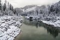
The Flathead River in Glacier National Park during winter


See also
 In Spanish: Río Flathead para niños
