Stillwater River (Flathead County, Montana) facts for kids
Quick facts for kids Stillwater River |
|
|---|---|

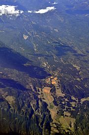
Aerial view of Stillwater River valley from the south (August 2013) with Lower Stillwater Lake slightly above the center of the image
|
|
| Country | Flathead and Lincoln County, Montana |
| Physical characteristics | |
| Main source | 48°48′06″N 114°42′43″W / 48.80167°N 114.71194°W |
| River mouth | 2,897 feet (883 m) 48°09′54″N 114°15′39″W / 48.16500°N 114.26083°W |
| Basin features | |
| River system | Columbia River |
The Stillwater River is a beautiful river located in Montana, USA. It flows through parts of Flathead and Lincoln County, Montana. This river is an important part of the local environment and joins other rivers on its journey.
Contents
Where the Stillwater River Starts
The Stillwater River begins its journey about 15 miles (24 kilometers) south of the border between Montana and Alberta, Canada. Its starting point is in the Kootenai National Forest. This area is west of the famous Glacier National Park.
The River's Path
From its source, the Stillwater River mainly flows south. It passes through several lakes, which are like natural stops along its way.
Lakes Along the Way
The river first reaches Duck Lake. After that, it flows into Upper Stillwater Lake. Then it continues to Lagoni Lake. Finally, it arrives at Lower Stillwater Lake. These lakes are all connected by the river.
Joining Other Rivers
After leaving Lower Stillwater Lake, the Stillwater River keeps flowing south. It eventually reaches the city of Kalispell. Here, it meets another river called the Whitefish River. They join together very close to where the Whitefish River flows into the larger Flathead River. The Flathead River is part of the even bigger Columbia River system.
 | Bessie Coleman |
 | Spann Watson |
 | Jill E. Brown |
 | Sherman W. White |

