Lincoln County, Montana facts for kids
Quick facts for kids
Lincoln County
|
|
|---|---|

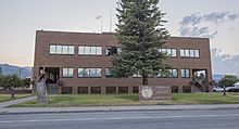
Lincoln County Courthouse
|
|

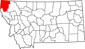
Location within the U.S. state of Montana
|
|
 Montana's location within the U.S. |
|
| Country | |
| State | |
| Founded | March 9, 1909 |
| Named for | Abraham Lincoln |
| Seat | Libby |
| Largest city | Libby |
| Area | |
| • Total | 3,675 sq mi (9,520 km2) |
| • Land | 3,613 sq mi (9,360 km2) |
| • Water | 62 sq mi (160 km2) 1.7% |
| Population
(2020)
|
|
| • Total | 19,677 |
| • Estimate
(2022)
|
21,525 |
| • Density | 5.3543/sq mi (2.0673/km2) |
| Time zone | UTC−7 (Mountain) |
| • Summer (DST) | UTC−6 (MDT) |
| Congressional district | 1st |
|
|
Lincoln County is a place in Montana, a state in the United States. In 2020, about 19,677 people lived there. Its main town, or "county seat," is Libby.
The county was started in 1909. It was named after President Abraham Lincoln. Lincoln County is right on Montana's northern border. This means it touches British Columbia, a province in Canada.
This area has lots of trees and mountains. It used to be part of another county called Flathead County. But people in Libby and Eureka wanted their own county. They asked the state government to let them separate. Libby won an election to become the main town of the new county.
Contents
Exploring Lincoln County's Geography
Lincoln County covers a large area. Official records show it is about 3,675 square miles (9,518 square kilometers). Most of this is land, and a small part (1.7%) is water. To the north, it shares a border with British Columbia in Canada.
The lowest spot in all of Montana is in Lincoln County. This point is on the Kootenai River. The river flows out of Montana and into Idaho. Upstream, a big structure called Libby Dam holds back water. This creates a huge lake called Lake Koocanusa. The lake's name comes from "Kootenai," "Canada," and "USA." It stretches into Canada's British Columbia.
Neighboring Areas
Lincoln County shares borders with several other places. These include other counties in Montana and Idaho, and even parts of Canada.
- Central Kootenay, British Columbia – to the northwest
- East Kootenay, British Columbia – to the north
- Flathead County – to the east
- Sanders County – to the south
- Bonner County, Idaho – to the southwest
- Boundary County, Idaho – to the northwest
Protected Natural Areas
Several important natural areas are partly located in Lincoln County. These areas help protect nature and offer places for outdoor activities.
- Pacific Northwest National Scenic Trail (part of a long hiking trail)
- Flathead National Forest (a large forest area)
- Kaniksu National Forest (another large forest area)
- Kootenai National Forest (a third large forest area)
Local Economy and Jobs
The economy of Lincoln County involves different types of jobs. In 2003, some of the biggest employers were:
| # | Employer | Number of Employees |
|---|---|---|
| 1 | Kootenai National Forest | 276 |
| 2 | Libby Public School District | 203 |
| 3 | St John's Lutheran Hospital | 182 |
| 4 | Lincoln County Government | 135 |
| 5 | Owens & Hurst Lumber | 120 |
People of Lincoln County
| Historical population | |||
|---|---|---|---|
| Census | Pop. | %± | |
| 1910 | 3,638 | — | |
| 1920 | 7,797 | 114.3% | |
| 1930 | 7,089 | −9.1% | |
| 1940 | 7,882 | 11.2% | |
| 1950 | 8,693 | 10.3% | |
| 1960 | 12,537 | 44.2% | |
| 1970 | 18,063 | 44.1% | |
| 1980 | 17,752 | −1.7% | |
| 1990 | 17,481 | −1.5% | |
| 2000 | 18,837 | 7.8% | |
| 2010 | 19,687 | 4.5% | |
| 2020 | 19,677 | −0.1% | |
| 2022 (est.) | 21,525 | 9.3% | |
| U.S. Decennial Census 1790–1960 1900–1990 1990–2000 2010–2020 |
|||
Population in 2020
According to the 2020 census, there were 19,677 people living in Lincoln County.
Population in 2010
In the 2010 census, there were 19,687 people. These people lived in 8,843 households. About 5,608 of these were families. The county had about 5.4 people per square mile.
Most people in the county (95.9%) were white. About 0.9% were American Indian. Other groups made up smaller percentages. People of Hispanic or Latino background made up 2.3% of the population.
The average age of people in Lincoln County was 48.9 years old.
Towns and Villages
Lincoln County has several communities. These include cities, towns, and smaller villages.
Cities
Towns
Census-designated places
These are areas that are like towns but are not officially incorporated as cities or towns.
Other Unincorporated Communities
These are even smaller communities that are not officially recognized as towns or cities.
- Dodge Summit
- Jennings
- Kootenai Falls
- Roosville
- Tobacco
- Yarnell
See also
 In Spanish: Condado de Lincoln (Montana) para niños
 | Mary Eliza Mahoney |
 | Susie King Taylor |
 | Ida Gray |
 | Eliza Ann Grier |


