Eureka, Montana facts for kids
Quick facts for kids
Eureka, Montana
|
|
|---|---|

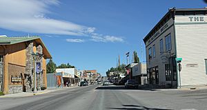
Looking northwest at downtown Eureka on U.S. Route 93
|
|

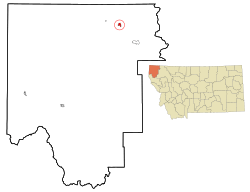
Location of Eureka, Montana
|
|
| Country | United States |
| State | Montana |
| County | Lincoln |
| Area | |
| • Total | 1.33 sq mi (3.43 km2) |
| • Land | 1.33 sq mi (3.43 km2) |
| • Water | 0.00 sq mi (0.00 km2) |
| Elevation | 2,707 ft (825 m) |
| Population
(2020)
|
|
| • Total | 1,380 |
| • Density | 1,040.72/sq mi (401.76/km2) |
| Time zone | UTC-7 (Mountain (MST)) |
| • Summer (DST) | UTC-6 (MDT) |
| ZIP code |
59917
|
| Area code(s) | 406 |
| FIPS code | 30-24850 |
| GNIS feature ID | 2412605 |
Eureka is a small town in Lincoln County, Montana, United States. It's located about 9 miles (14 km) south of the Canada-US border. In 2020, about 1,380 people lived there.
Contents
History of Eureka
Eureka started in the early 1880s. People moved there from Missoula, Montana, and from Canada. At first, it was called Deweyville. It was one of the last places in Montana to be settled during the frontier days.
Logging, which is cutting down trees for wood, was very important for Eureka. For many years, it was the main way people earned money. Eureka was even known as the "Christmas Tree Capital of the World." Many evergreen trees were sent from Eureka to cities for holiday sales.
In the early 1800s, a Canadian fur trapper and explorer named David Thompson visited the area. He was looking for a way to reach the Pacific Ocean. Early explorers found Native Americans growing a special kind of tobacco there. Because of this, they named the area the Tobacco Plains. Today, people in Eureka have a "Tobacco Valley Rendezvous" every April. It's a fun event that remembers Thompson's visit.
A United States President, Harry S. Truman, visited Eureka on October 1, 1952. He gave a speech there to support Adlai Stevenson, who was running for president.
Geography of Eureka
Eureka is located along the Tobacco River. This area is known as the Tobacco Valley in the United States. North of the border in British Columbia, Canada, it's called the Tobacco Plains.
The town is about 66 miles (106 km) from Kalispell. The Tobacco River flows through the western part of Eureka. The town covers about 1.01 square miles (2.62 square kilometers) of land. There is no water area within the town limits.
Eureka's Climate
Eureka has a special "mild microclimate." This means its weather is often warmer than nearby cities like Kalispell and Whitefish in Montana. It's also warmer than Invermere and Fernie in British Columbia.
In summer, afternoons are usually hot and sunny. The air is not very humid. Winters are often cloudy, but they don't get as extremely cold as other places nearby.
| Climate data for Eureka, Montana (Eureka Ranger Station), 1991–2020 normals, extremes 1960–present | |||||||||||||
|---|---|---|---|---|---|---|---|---|---|---|---|---|---|
| Month | Jan | Feb | Mar | Apr | May | Jun | Jul | Aug | Sep | Oct | Nov | Dec | Year |
| Record high °F (°C) | 63 (17) |
66 (19) |
78 (26) |
89 (32) |
94 (34) |
106 (41) |
105 (41) |
106 (41) |
98 (37) |
86 (30) |
68 (20) |
59 (15) |
106 (41) |
| Mean maximum °F (°C) | 48.0 (8.9) |
51.1 (10.6) |
63.3 (17.4) |
74.7 (23.7) |
84.7 (29.3) |
90.6 (32.6) |
97.3 (36.3) |
97.1 (36.2) |
88.6 (31.4) |
73.4 (23.0) |
55.9 (13.3) |
46.4 (8.0) |
99.1 (37.3) |
| Mean daily maximum °F (°C) | 32.3 (0.2) |
38.6 (3.7) |
49.2 (9.6) |
59.5 (15.3) |
69.9 (21.1) |
76.6 (24.8) |
86.5 (30.3) |
86.0 (30.0) |
74.8 (23.8) |
57.4 (14.1) |
41.4 (5.2) |
31.4 (−0.3) |
58.6 (14.8) |
| Daily mean °F (°C) | 25.8 (−3.4) |
29.8 (−1.2) |
38.3 (3.5) |
46.8 (8.2) |
55.9 (13.3) |
62.5 (16.9) |
69.6 (20.9) |
68.6 (20.3) |
59.4 (15.2) |
46.3 (7.9) |
34.4 (1.3) |
26.1 (−3.3) |
47.0 (8.3) |
| Mean daily minimum °F (°C) | 19.3 (−7.1) |
21.1 (−6.1) |
27.5 (−2.5) |
34.1 (1.2) |
41.9 (5.5) |
48.5 (9.2) |
52.7 (11.5) |
51.2 (10.7) |
43.9 (6.6) |
35.1 (1.7) |
27.4 (−2.6) |
20.8 (−6.2) |
35.3 (1.8) |
| Mean minimum °F (°C) | −6.7 (−21.5) |
0.1 (−17.7) |
9.2 (−12.7) |
21.0 (−6.1) |
29.0 (−1.7) |
37.0 (2.8) |
42.3 (5.7) |
39.0 (3.9) |
30.3 (−0.9) |
17.2 (−8.2) |
7.9 (−13.4) |
−1.0 (−18.3) |
−15.6 (−26.4) |
| Record low °F (°C) | −35 (−37) |
−30 (−34) |
−23 (−31) |
8 (−13) |
22 (−6) |
27 (−3) |
30 (−1) |
30 (−1) |
18 (−8) |
0 (−18) |
−23 (−31) |
−50 (−46) |
−50 (−46) |
| Average precipitation inches (mm) | 0.92 (23) |
0.72 (18) |
0.90 (23) |
1.00 (25) |
1.78 (45) |
2.53 (64) |
1.13 (29) |
1.05 (27) |
1.27 (32) |
1.24 (31) |
1.24 (31) |
1.22 (31) |
15 (379) |
| Average snowfall inches (cm) | 8.5 (22) |
5.9 (15) |
3.7 (9.4) |
1.0 (2.5) |
0.2 (0.51) |
0.0 (0.0) |
0.0 (0.0) |
0.0 (0.0) |
0.0 (0.0) |
0.6 (1.5) |
5.0 (13) |
10.2 (26) |
35.1 (89.91) |
| Average extreme snow depth inches (cm) | 7.5 (19) |
5.0 (13) |
3.7 (9.4) |
0.7 (1.8) |
0.0 (0.0) |
0.0 (0.0) |
0.0 (0.0) |
0.0 (0.0) |
0.0 (0.0) |
0.2 (0.51) |
3.5 (8.9) |
7.1 (18) |
10.8 (27) |
| Average precipitation days (≥ 0.01 in) | 10.5 | 7.8 | 8.8 | 8.5 | 9.9 | 10.4 | 6.6 | 5.2 | 6.7 | 8.6 | 9.3 | 10.2 | 102.5 |
| Average snowy days (≥ 0.1 in) | 6.2 | 3.9 | 2.5 | 0.5 | 0.1 | 0.0 | 0.0 | 0.0 | 0.0 | 0.4 | 2.4 | 6.3 | 22.3 |
| Source 1: NOAA | |||||||||||||
| Source 2: National Weather Service | |||||||||||||
Population of Eureka
| Historical population | |||
|---|---|---|---|
| Census | Pop. | %± | |
| 1910 | 603 | — | |
| 1920 | 1,082 | 79.4% | |
| 1930 | 860 | −20.5% | |
| 1940 | 912 | 6.0% | |
| 1950 | 929 | 1.9% | |
| 1960 | 1,229 | 32.3% | |
| 1970 | 1,195 | −2.8% | |
| 1980 | 1,119 | −6.4% | |
| 1990 | 1,043 | −6.8% | |
| 2000 | 1,017 | −2.5% | |
| 2010 | 1,037 | 2.0% | |
| 2020 | 1,380 | 33.1% | |
| U.S. Decennial Census | |||
2010 Census Information
In 2010, the town of Eureka had 1,037 people living there. These people lived in 442 households, and 261 of these were families. The town had about 1027 people per square mile (397 people per square kilometer).
Most of the people in Eureka (94.8%) were White. A smaller number were Native American (0.6%), Asian (0.4%), or from other backgrounds. About 4.3% of the population identified as Hispanic or Latino.
About 28.5% of households had children under 18 living with them. Many households (43%) were married couples. Some households had a female head (10.4%) or a male head (5.7%) without a spouse. About 36.2% of all households were single individuals.
The average age in Eureka was 43.3 years old. About 23.9% of residents were under 18. About 23.1% were 65 years or older. The town had slightly more females (54.6%) than males (45.4%).
Things to Do in Eureka
The area around Eureka is very beautiful and offers many outdoor activities. The Pacific Northwest Trail is a very long hiking trail, about 1,200 miles (1,931 km) long. It goes from the Continental Divide all the way to the Pacific Ocean, and it passes through Eureka.
About 45 minutes from town is the Ten Lakes Scenic Area. This large area of 14,945 acres (60.48 km²) is set aside for people to enjoy the backcountry. West of Eureka is Lake Koocanusa, a big lake perfect for all kinds of water sports and fun.
Every April, Eureka hosts a big event called Rendezvous Days. It's a fun celebration with unique activities like bed races and black powder events. In the summer, you can enjoy "Shakespeare in the Park," where plays are performed outdoors. There's also "The Bull Thing," which is a Professional Bull Riders event. Eureka also hosts the Lincoln County Fair, which has carnival rides, rodeos, and booths from local businesses.
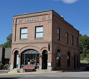
Eureka has two buildings listed on the National Register of Historic Places. These are the Eureka Community Hall and the Farmers and Merchants State Bank. The town also has The Historical Village. This is a group of old buildings that have been kept and furnished with items from the past.
The town has a public library, which is part of the Lincoln County Public Libraries system.
Education in Eureka
Eureka Public Schools teach students from kindergarten through 12th grade. Their sports teams are known as the Lions. In the 2021–2022 school year, the elementary school (kindergarten to 4th grade) had 237 students. The middle school (5th to 8th grade) had 238 students.
Lincoln County High School is a "Class B" high school. This classification helps decide how athletic competitions are organized. In the 2021–2022 school year, 293 students were enrolled at the high school.
Media in Eureka
The Tobacco Valley News is a newspaper that comes out once a week. You can read it in print or online.
Eureka also has three radio stations. KEUK is part of the Montana Public Radio network. KEUR-LP is a religious radio channel. KZXT is a local station that plays adult contemporary music.
Transportation and Services
US Route 93 is a main highway that goes through Eureka from north to south. Montana Highway 37 ends about 5 miles (8 km) north of town.
The Eureka Airport is a public airport located 5 miles (8 km) north of town. If you need to fly on a commercial airline, the closest major airport is Glacier Park International Airport. It is about 62 miles (100 km) south of Eureka.
For healthcare, Logan Health has three medical clinics in Eureka.
See also
 In Spanish: Eureka (Montana) para niños
 | Claudette Colvin |
 | Myrlie Evers-Williams |
 | Alberta Odell Jones |


