Boundary County, Idaho facts for kids
Quick facts for kids
Boundary County
|
||
|---|---|---|

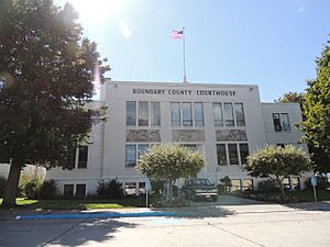
Boundary County Courthouse
|
||
|
||

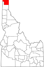
Location within the U.S. state of Idaho
|
||
 Idaho's location within the U.S. |
||
| Country | ||
| State | ||
| Founded | January 23, 1915 | |
| Named for | Canada–United States border | |
| Seat | Bonners Ferry | |
| Largest city | Bonners Ferry | |
| Area | ||
| • Total | 1,278 sq mi (3,310 km2) | |
| • Land | 1,269 sq mi (3,290 km2) | |
| • Water | 9.3 sq mi (24 km2) 0.7% | |
| Population
(2020)
|
||
| • Total | 12,056 | |
| • Estimate
(2023)
|
13,557 |
|
| • Density | 9.433/sq mi (3.6423/km2) | |
| Time zone | UTC−8 (Pacific) | |
| • Summer (DST) | UTC−7 (PDT) | |
| Congressional district | 1st | |
Boundary County is the northernmost county in the state of Idaho. It's located in the United States. In 2020, about 12,056 people lived there. The main city and county seat is Bonners Ferry.
Boundary County was created on January 23, 1915. It got its name because it shares a border with Canada. This makes it the only county in Idaho with an international border. It's also one of only three counties in the whole United States that borders two states and a foreign country.
Contents
History of Boundary County
Boundary County was formed in 1915 from Bonner County. It was named "Boundary County" because it sits on the border of Canada, Washington, and Montana.
The area began to be settled when Bonners Ferry was started in 1864. This town was built on the Kootenai River. For a while, settlement was mostly just around the ferry. By 1890, more people started to arrive. The town of Bonners Ferry was officially established in 1893.
At first, there were only a few small farms and mining spots. But the timber industry (logging) started to grow. By 1900, other areas like Boulder (now Kootenai) and Naples also began to develop.
Geography of Boundary County
Boundary County covers about 1,278 square miles. Most of this area is land, with a small part being water.
Neighboring Areas
Boundary County shares its borders with:
- Lincoln County, Montana – to the east
- Bonner County – to the south
- Pend Oreille County, Washington – to the west
- Regional District of Central Kootenay, British Columbia, Canada – to the north
Protected Natural Areas
Some parts of Boundary County are protected natural areas. These include:
- Pacific Northwest National Scenic Trail (a long hiking trail)
- Kaniksu National Forest (a large forest)
- Kootenai National Forest (another large forest)
- Kootenai National Wildlife Refuge (a place for wildlife)
Getting Around Boundary County
Main Roads
You can travel through Boundary County using these important highways:
Airport
The Boundary County Airport is a public airport. It's located just a couple of miles northeast of Bonners Ferry.
People of Boundary County
| Historical population | |||
|---|---|---|---|
| Census | Pop. | %± | |
| 1920 | 4,474 | — | |
| 1930 | 4,555 | 1.8% | |
| 1940 | 5,987 | 31.4% | |
| 1950 | 5,908 | −1.3% | |
| 1960 | 5,809 | −1.7% | |
| 1970 | 6,371 | 9.7% | |
| 1980 | 7,289 | 14.4% | |
| 1990 | 8,332 | 14.3% | |
| 2000 | 9,871 | 18.5% | |
| 2010 | 10,972 | 11.2% | |
| 2020 | 12,056 | 9.9% | |
| 2023 (est.) | 13,557 | 23.6% | |
| U.S. Decennial Census 1790–1960 1900–1990 1990–2000 2010–2020 2020 |
|||
In 2010, there were 10,972 people living in Boundary County. There were 4,421 households, which are groups of people living together. The average household had about 2.47 people. The average age of people in the county was 42.8 years old.
Most people in the county were white (94.8%). Other groups included American Indian, Asian, and Black or African American. About 3.7% of the population was of Hispanic or Latino origin. Many people had ancestors from Germany, England, and Ireland.
Media in Boundary County
Television
Local TV stations from Spokane, Washington can be watched in Boundary County.
Radio
- KBFI, 1450 AM: This radio station has been in Bonners Ferry since 1983.
- KSBF, 88.9 FM: This station started broadcasting in 2024. It plays Christian music and programs.
- KQFR, 90.7 FM: This station began broadcasting in 2022. It also plays Christian content and is licensed to Moyie Springs.
Newspapers
The main newspaper for Bonners Ferry is the weekly Bonners Ferry Herald.
Towns and Communities
Cities
Other Communities
These are smaller communities that are not officially cities:
- Copeland
- Eastport
- Good Grief
- Naples
- Porthill
- Curley Creek
Education in Boundary County
Boundary County has one main school district, called Boundary County School District 101.
The county is also part of the area served by North Idaho College.
See also
 In Spanish: Condado de Boundary para niños
 | Janet Taylor Pickett |
 | Synthia Saint James |
 | Howardena Pindell |
 | Faith Ringgold |


