Bonner County, Idaho facts for kids
Quick facts for kids
Bonner County
|
||
|---|---|---|

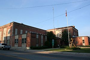
Bonner County Courthouse in Sandpoint
|
||
|
||

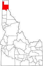
Location within the U.S. state of Idaho
|
||
 Idaho's location within the U.S. |
||
| Country | ||
| State | ||
| Founded | February 21, 1907 | |
| Named for | Edwin L. Bonner | |
| Seat | Sandpoint | |
| Largest city | Sandpoint | |
| Area | ||
| • Total | 1,919 sq mi (4,970 km2) | |
| • Land | 1,735 sq mi (4,490 km2) | |
| • Water | 185 sq mi (480 km2) 9.6% | |
| Population
(2020)
|
||
| • Total | 47,110 | |
| • Estimate
(2023)
|
52,547 |
|
| • Density | 24.549/sq mi (9.479/km2) | |
| Time zone | UTC−8 (Pacific) | |
| • Summer (DST) | UTC−7 (PDT) | |
| Congressional district | 1st | |
Bonner County is a county located in the northern part of Idaho, a state in the United States. In 2020, about 47,110 people lived there. The main city and county seat is Sandpoint.
Bonner County was created in 1907. It was formed from parts of Kootenai County. The county was named after Edwin L. Bonner, who ran a ferry service in the area.
Contents
Discovering Bonner County's Past
Bonner County was officially formed on February 21, 1907. It got its name from Edwin L. Bonner, a person who helped people travel by operating a ferry.
Before Bonner County existed, the Idaho Legislature created other counties in 1864. These included Lah-Toh and Kootenai counties. Kootenai County was very large back then. It covered much of what is now Bonner and Boundary counties. A trading post called Sin-na-ac-qua-teen was named the county seat. However, there weren't enough people living there to set up a proper government.
Because of this, in 1867, the legislature changed the rules. They combined the areas into one county, keeping the name Kootenai. Later, in 1881, Rathdrum became the county seat for Kootenai County.
A small part of what is now Bonner County was not part of any county for a long time. This was from 1863 to 1907. When Bonner County was created in 1907, this area finally became part of a county. In 1915, Boundary County was formed from the northern part of Bonner County.
Geography and Nature
Bonner County covers a total area of about 1,919 square miles. Most of this is land, about 1,735 square miles. The rest, about 185 square miles, is water. The highest point in the county is Scotchman Peak. This peak reaches an elevation of 7,018 feet (2,139 meters).
Neighboring Counties
Bonner County shares its borders with several other counties:
- Pend Oreille County, Washington (to the northwest)
- Boundary County (to the north)
- Lincoln County, Montana (to the east, also a time zone border)
- Sanders County, Montana (to the southeast, also a time zone border)
- Shoshone County (to the southeast)
- Kootenai County (to the south)
- Spokane County, Washington (to the southwest)
Protected Natural Areas
Several national protected areas are partly located in Bonner County:
- Pacific Northwest National Scenic Trail (a long hiking trail)
- Coeur d'Alene National Forest
- Kaniksu National Forest
- Kootenai National Forest
Main Roads
These are the major highways that run through Bonner County:
Rivers and Lakes
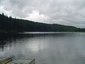
Bonner County is home to many beautiful bodies of water:
- Albeni Falls Dam
- Clark Fork River
- Cocolalla
- Kelso Lake
- Lake Pend Oreille
- Pack River
- Pend Oreille River
- Priest Lake
Population and People
The number of people living in Bonner County has grown over the years. Here's a look at the population changes:
| Historical population | |||
|---|---|---|---|
| Census | Pop. | %± | |
| 1910 | 13,588 | — | |
| 1920 | 12,957 | −4.6% | |
| 1930 | 13,152 | 1.5% | |
| 1940 | 15,667 | 19.1% | |
| 1950 | 14,853 | −5.2% | |
| 1960 | 15,587 | 4.9% | |
| 1970 | 15,560 | −0.2% | |
| 1980 | 24,163 | 55.3% | |
| 1990 | 26,622 | 10.2% | |
| 2000 | 36,835 | 38.4% | |
| 2010 | 40,877 | 11.0% | |
| 2020 | 47,110 | 15.2% | |
| 2023 (est.) | 52,547 | 28.5% | |
| U.S. Decennial Census 1790–1960 1900–1990 1990–2000 2010–2020 |
|||
In 2010, there were 40,877 people living in the county. Most people were white, making up about 96% of the population. About 2.2% of the people were of Hispanic or Latino origin. The average age of people in the county was around 45.8 years old.
Cities and Towns
Bonner County has several cities and smaller communities.
Cities
Census-designated places
These are areas that are like towns but are not officially incorporated as cities:
Unincorporated communities
These are smaller communities without their own local government:
Fun in the Snow
- Schweitzer Mountain Resort is a popular place for skiing and snowboarding in Bonner County.
Learning and Schools
Children in Bonner County attend schools in several different school districts:
- Lake Pend Oreille School District 84
- Lakeland Joint School District 272
- West Bonner County School District 83
The county is also near North Idaho College, which offers higher education.
See also
 In Spanish: Condado de Bonner para niños
 | Ernest Everett Just |
 | Mary Jackson |
 | Emmett Chappelle |
 | Marie Maynard Daly |


