Troy, Montana facts for kids
Quick facts for kids
Troy, Montana
|
|
|---|---|
 |
|

Location of Troy, Montana
|
|
| Country | United States |
| State | Montana |
| County | Lincoln |
| Area | |
| • Total | 0.85 sq mi (2.20 km2) |
| • Land | 0.85 sq mi (2.19 km2) |
| • Water | 0.01 sq mi (0.01 km2) |
| Elevation | 1,900 ft (600 m) |
| Population
(2020)
|
|
| • Total | 797 |
| • Density | 942.08/sq mi (363.57/km2) |
| Time zone | UTC-7 (Mountain (MST)) |
| • Summer (DST) | UTC-6 (MDT) |
| ZIP code |
59935
|
| Area code(s) | 406 |
| FIPS code | 30-75025 |
| GNIS feature ID | 2412101 |
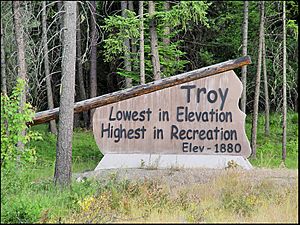
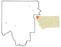
Troy is a small city in Lincoln County, Montana, United States. In 2020, about 797 people lived there. It is special because it sits at the lowest elevation of any town in Montana. Troy is located on U.S. Route 2, near Montana Highway 56. It is nestled in the Kootenai River gorge, close to the Kootenai National Forest.
The area was first home to Native American tribes like the Kutenai, Salish, and Piegan Blackfeet. Miners began to settle here in the 1880s. Troy became an official town in 1892. It grew quickly after the Great Northern Railway built a freight station nearby. This brought many workers, miners, and their families to the town.
Troy faced challenges like wildfires in 1910 and a drop in population in the late 1920s. However, it grew again in later years. The town also dealt with contamination from nearby vermiculite mines. These mines had a dangerous type of asbestos. The United States Environmental Protection Agency (EPA) helped clean up the area. By 2015, most of the risk was reduced.
Today, Troy's economy relies on mining, education, retail, and tourism. Natural spots like the Kootenai Falls attract visitors. These falls have even appeared in movies like The River Wild (1994) and The Revenant (2015). Troy has a public school district and a public library.
Contents
Exploring Troy's Past
Before settlers arrived, different indigenous peoples lived in the Troy area. The Kutenai and Salish tribes lived there most recently. The Piegan Blackfeet were there even earlier. They moved between camps based on where they could find plants and fish. In winter, they stayed in lower areas. In summer and fall, they moved to higher lands.
The area remained mostly unsettled until gold was found in the 1860s. Later, galena and vermiculite were discovered in the 1880s. In 1886, the first miners came to the Kootenay River. They set up a tent camp and started claiming land. In 1892, a man named William O'Brien officially surveyed the area and named it Troy.
How Troy Grew
In 1892, Troy was officially registered as a town. It grew very fast because the Great Northern Railway chose a spot nearby for a "division yard." This was a place where trains would sort freight. The town's first hotel, the Windsor Hotel, was built. Early Troy was a lively place with many businesses.
More stores opened in 1893. The first one-room schoolhouse was built in 1894. More mining companies and land claims appeared. Services like ferries also started to help people cross the river. Gold was found on the Yaak River in 1895, which brought even more growth.
The 1910s brought many changes. Wildfires in 1910 came close to Troy but mostly affected the Kootenai National Forest. In 1912, Troy got its first bridge over the Kootenai River. Before this, people crossed by horse or ferry. Phone service arrived in 1913. A volunteer fire department was also created. By 1920, Troy had a Chinese restaurant, a church, and an electric plant.
Troy's population reached 1,000 people in 1924. The Lincoln Theatre also opened that year. The town's population was highest around 1926. But in March 1926, the Great Northern Railway moved its freight terminal. This meant fewer jobs in Troy. Fires also destroyed a processing plant in 1927 and a sawmill in 1928. These were not rebuilt, and mining slowed down.
During the Great Depression in 1930, Troy's population dropped to 428. Even so, the Lincoln Theatre started showing movies with sound. The Windsor Hotel was renamed the Great Northern Hotel. This hotel later burned down in 1941. Today, a coffee house and cable shop are in its place. The Lincoln Theatre was updated in 1994.
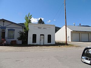
In 2006, the Troy Jail and the Theodore Roosevelt Memorial Bridge were added to the National Register of Historic Places. This means they are important historical sites.
Cleaning Up the Environment
People became worried about pollution in the area around Libby and Troy. This pollution came from vermiculite mines in Libby. The mines had a dangerous type of asbestos called Libby Amphibole asbestos (LA). In 1999, the United States Environmental Protection Agency (EPA) started to investigate.
Cleanup efforts began in 2000. In 2002, the EPA added the site to its Superfund National Priorities List. This list is for the most polluted places in the country. In 2009, the EPA declared a Public Health Emergency. This was the first time they had done this. It helped provide health care to people affected by the asbestos.
By 2015, the EPA found that the cleanup had greatly reduced the risk from asbestos. By the end of 2018, the EPA had removed a lot of contaminated soil. The cleanup in the area was mostly finished that year. The remaining contamination is mainly in the forests and property near the old mine. In 2020, the EPA handed control of the site over to Montana's environmental department.
Troy's Location and Landscape
Troy is located in a valley. The Kootenai River flows through it. To the northeast are the Purcell Mountains. To the southwest are the Cabinet Mountains.
The city covers about 0.78 square miles (2.02 square kilometers). Most of this is land, with a small amount of water. Troy is about 1,800 feet (549 meters) above sea level. It is the lowest town in Montana. Troy is about 12 miles (19 km) from the border of Montana and Idaho. The closest city is Libby, which is about 18 miles (29 km) away.
The Troy Mine used to produce silver and copper. It was planned to close in 2015.
An early worker described the area as having "a carpet of velvety green grass, thickly studded with wild flowers." Nearby, there are groves of very old western red cedar trees. Some of these trees are up to 12 feet (3.7 meters) wide. These forests are home to animals like pikas and flying squirrels.
The Kootenai River Gorge is made of sandstone and thin layers of shale. These rocks were formed about 1.5 million years ago. At that time, much of Montana was covered by water. You can still see ancient ripple marks and large stromatolites (remains of old algae mats) in the canyon.
Weather in Troy
Troy has a climate with big temperature changes between seasons. Summers can be warm to hot, and sometimes humid. Winters are cold, and can be very cold. This type of climate is called a humid continental climate.
The average yearly temperature in Troy is about 46.4°F (8.0°C). The average yearly rainfall is about 24.6 inches (625 mm). Flooding can sometimes be a problem in the area.
| Climate data for Troy, Montana (1991–2020 normals, extremes 1960–present) | |||||||||||||
|---|---|---|---|---|---|---|---|---|---|---|---|---|---|
| Month | Jan | Feb | Mar | Apr | May | Jun | Jul | Aug | Sep | Oct | Nov | Dec | Year |
| Record high °F (°C) | 57 (14) |
64 (18) |
82 (28) |
87 (31) |
97 (36) |
109 (43) |
110 (43) |
110 (43) |
102 (39) |
84 (29) |
69 (21) |
60 (16) |
110 (43) |
| Mean daily maximum °F (°C) | 32.7 (0.4) |
39.0 (3.9) |
49.7 (9.8) |
59.1 (15.1) |
69.8 (21.0) |
75.8 (24.3) |
86.7 (30.4) |
86.0 (30.0) |
74.9 (23.8) |
56.5 (13.6) |
40.6 (4.8) |
32.4 (0.2) |
58.6 (14.8) |
| Daily mean °F (°C) | 27.8 (−2.3) |
31.3 (−0.4) |
38.9 (3.8) |
46.0 (7.8) |
54.9 (12.7) |
61.0 (16.1) |
68.1 (20.1) |
66.8 (19.3) |
58.3 (14.6) |
45.6 (7.6) |
34.9 (1.6) |
27.9 (−2.3) |
46.8 (8.2) |
| Mean daily minimum °F (°C) | 22.9 (−5.1) |
23.6 (−4.7) |
28.0 (−2.2) |
33.0 (0.6) |
40.1 (4.5) |
46.2 (7.9) |
49.4 (9.7) |
47.7 (8.7) |
41.7 (5.4) |
34.6 (1.4) |
29.3 (−1.5) |
23.5 (−4.7) |
35.0 (1.7) |
| Record low °F (°C) | −28 (−33) |
−20 (−29) |
−6 (−21) |
8 (−13) |
22 (−6) |
27 (−3) |
26 (−3) |
31 (−1) |
17 (−8) |
−3 (−19) |
−14 (−26) |
−35 (−37) |
−35 (−37) |
| Average precipitation inches (mm) | 2.63 (67) |
1.85 (47) |
2.44 (62) |
1.65 (42) |
1.79 (45) |
2.52 (64) |
0.88 (22) |
0.71 (18) |
1.21 (31) |
2.42 (61) |
3.50 (89) |
2.79 (71) |
24.39 (620) |
| Average snowfall inches (cm) | 14.2 (36) |
9.1 (23) |
4.7 (12) |
1.5 (3.8) |
0.1 (0.25) |
0.0 (0.0) |
0.0 (0.0) |
0.0 (0.0) |
0.0 (0.0) |
0.0 (0.0) |
5.8 (15) |
14.3 (36) |
49.7 (126.05) |
| Average precipitation days (≥ 0.01 in) | 13.6 | 9.6 | 11.2 | 8.9 | 10.3 | 10.5 | 4.7 | 4.5 | 6.4 | 9.1 | 14.1 | 12.6 | 115.5 |
| Average snowy days (≥ 0.1 in) | 6.2 | 4.3 | 2.8 | 1.1 | 0.0 | 0.0 | 0.0 | 0.0 | 0.0 | 0.1 | 3.4 | 7.1 | 25 |
| Source: NOAA | |||||||||||||
People of Troy
| Historical population | |||
|---|---|---|---|
| Census | Pop. | %± | |
| 1920 | 763 | — | |
| 1930 | 498 | −34.7% | |
| 1940 | 796 | 59.8% | |
| 1950 | 770 | −3.3% | |
| 1960 | 855 | 11.0% | |
| 1970 | 1,046 | 22.3% | |
| 1980 | 1,088 | 4.0% | |
| 1990 | 953 | −12.4% | |
| 2000 | 957 | 0.4% | |
| 2010 | 938 | −2.0% | |
| 2020 | 797 | −15.0% | |
| U.S. Decennial Census | |||
Population in 2010
In 2010, Troy had 938 people living in 454 households. About 240 of these were families. The city had about 1,234 people per square mile. Most of the people (94.3%) were White. There were also small percentages of African American, Native American, and Asian people. About 1.9% of the population was Hispanic or Latino.
About 25% of households had children under 18. About 37% were married couples. The average age in Troy was 46.8 years. About 20% of residents were under 18. About 16.8% were 65 or older. The population was almost evenly split between males (49.3%) and females (50.7%).
Jobs and Fun in Troy
Troy's economy today focuses on mining, education, retail, and tourism. In the past, mining and logging were the main jobs. A train yard, sawmill, and ore processing plant were once the biggest employers. But these were lost in the late 1920s due to relocation and fires.
Gold, galena, and vermiculite were mined starting in the late 1800s. During World War I, Troy's mines produced lead, zinc, and silver. In 2020, Troy's public schools were checked for solar power potential. The high school building was found to have good potential. Since 2008, the school and city have used wood pellet waste for some of their energy.
Popular attractions nearby include the Kootenai Falls and the Kootenai Falls Swinging Bridge. The bridge was rebuilt in 2019 because it became so popular. The Theodore Roosevelt Memorial Bridge in Troy is also a historic landmark.
There are many outdoor activities to enjoy. These include hiking, snowmobiling, camping, and boating. You can also go rafting, bird watching, fishing, and geocaching. The Rocky Mountain Elk Foundation was started by four Troy hunters. They wanted to help protect elk and other wildlife. The Troy Museum and Visitors' Center has a disc golf course. It also hosts art events. Nearby parks hold cultural and music festivals.
Learning in Troy
Troy has a public library. It is part of the Lincoln County Public Libraries system. The Troy branch opened in 1922.
Troy's first school was a one-room schoolhouse built in 1894. In 1937, two other local schools joined the Troy public school district. The district includes:
- W.F. Morrison Elementary School (for students from Kindergarten to Sixth grade)
- Troy Junior-Senior High School (for students from Seventh grade to Twelfth grade)
The high school offers adult education classes in the fall and spring. It also has a "school-to-work" program. Students can work on summer projects related to the local economy. An AmeriCorps volunteer helps students with college applications and community activities. In 2017, the Troy Art Club made ceramic ornaments for the US National Christmas Tree. This led them to create a business called Wild In Montana. It helps the community and teaches students real-world skills.
Other schools with Troy addresses include:
- McCormick Elementary School (Kindergarten to 8th grade)
- Yaak Elementary School (Kindergarten to 8th grade)
Students in Troy can get in-district tuition at Flathead Valley Community College (FVCC) in Kalispell, Montana. They can also attend FVCC's Lincoln County Campus in Libby. This campus has a learning center where students can take free classes to prepare for their GED exams.
Getting Around Troy
Troy is located on U.S. Route 2. It is between Yaak to the north and Libby to the southeast. Montana Highway 56 is about three miles southeast of Troy.
The Troy Airport is one mile northwest of most of the town.
The closest Amtrak train stop is Libby station, which is about 18 miles (29 km) away. The Empire Builder train used to stop in Troy until 1973.
Famous People from Troy
- Les Balsiger, a religious activist who had an office in Troy.
- Rachel Dolezal, a civil rights activist.
- B. C. Edwards, a football coach who died in Troy.
- Genevieve Pezet, an American-French artist.
- Jay Ward, a Major League Baseball player who retired in Troy.
See also
 In Spanish: Troy (Montana) para niños
 | Toni Morrison |
 | Barack Obama |
 | Martin Luther King Jr. |
 | Ralph Bunche |


