Libby, Montana facts for kids
Quick facts for kids
Libby, Montana
|
|
|---|---|

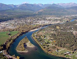
Looking west-southwest
|
|

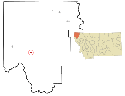
Location of Libby, Montana
|
|
| Country | United States |
| State | Montana |
| County | Lincoln |
| Area | |
| • Total | 1.88 sq mi (4.86 km2) |
| • Land | 1.84 sq mi (4.77 km2) |
| • Water | 0.04 sq mi (0.09 km2) |
| Elevation | 2,103 ft (641 m) |
| Population
(2020)
|
|
| • Total | 2,775 |
| • Density | 1,506.51/sq mi (581.64/km2) |
| Time zone | UTC-7 (Mountain (MST)) |
| • Summer (DST) | UTC-6 (MDT) |
| ZIP code |
59923
|
| Area code(s) | 406 |
| FIPS code | 30-43450 |
| GNIS feature ID | 2410831 |
Libby is a city in northwestern Montana, United States. It is the main city of Lincoln County. In 2020, about 2,775 people lived there.
Libby faced a big challenge because of tiny fibers from nearby mines. These mines had a material called vermiculite that was mixed with a dangerous substance called asbestos. This caused health problems for many people in the town. Because of this, the U.S. Environmental Protection Agency (EPA) stepped in to help clean up the area. By 2015, most of the danger was gone.
The area around Libby is very beautiful. Places like Kootenai Falls attract many visitors. These falls have even been shown in movies like The River Wild (1994) and The Revenant (2015). Libby has schools and a public library. It also has a campus for Flathead Valley Community College.
Contents
History of Libby
Long ago, huge sheets of ice called glaciers carved out the valleys and lakes around Libby. The first indigenous peoples came to this area at least 8,000 years ago. They hunted animals and gathered plants for food.
The first known American settler, David Thompson, arrived in the 1800s. Early jobs in the area included fur trading, building railroads, mining, and cutting down trees for wood. In 1867, many miners came to Libby Creek looking for valuable minerals. By the 1870s, most of them had left. In 1892, a train line called the Great Northern Railway came through. The town then moved to a new spot downstream and its name was shortened from Libbysville to Libby.
Geography and Climate
Libby is located on U.S. Route 2, where it meets Montana Highway 37. It sits where Libby Creek flows into the Kootenai River.
The city covers about 1.95 square miles (4.86 square kilometers). Most of this is land, with a small part being water. Libby is in the Kootenai National Forest. It is surrounded by the Cabinet Mountains to the south and the Purcell Mountains to the north. The town is in the middle of the Kootenai Valley, along the Kootenai River. It is also downstream from the Libby Dam. Libby is about 2,096 feet (639 meters) above sea level.
Libby has a continental climate. This means it has warm summers and cold winters.
| Climate data for Libby, Montana, 1991–2020 normals, extremes 1895–2022 | |||||||||||||
|---|---|---|---|---|---|---|---|---|---|---|---|---|---|
| Month | Jan | Feb | Mar | Apr | May | Jun | Jul | Aug | Sep | Oct | Nov | Dec | Year |
| Record high °F (°C) | 56 (13) |
65 (18) |
75 (24) |
90 (32) |
102 (39) |
107 (42) |
110 (43) |
109 (43) |
105 (41) |
89 (32) |
73 (23) |
65 (18) |
110 (43) |
| Mean maximum °F (°C) | 45.3 (7.4) |
51.6 (10.9) |
65.7 (18.7) |
78.4 (25.8) |
88.2 (31.2) |
94.1 (34.5) |
99.9 (37.7) |
99.3 (37.4) |
91.1 (32.8) |
75.7 (24.3) |
54.6 (12.6) |
43.1 (6.2) |
101.5 (38.6) |
| Mean daily maximum °F (°C) | 34.4 (1.3) |
40.9 (4.9) |
51.8 (11.0) |
61.5 (16.4) |
72.6 (22.6) |
79.6 (26.4) |
89.3 (31.8) |
89.6 (32.0) |
77.6 (25.3) |
58.5 (14.7) |
41.1 (5.1) |
32.8 (0.4) |
60.8 (16.0) |
| Daily mean °F (°C) | 27.9 (−2.3) |
31.5 (−0.3) |
39.3 (4.1) |
46.6 (8.1) |
55.6 (13.1) |
62.5 (16.9) |
69.2 (20.7) |
68.5 (20.3) |
59.2 (15.1) |
46.2 (7.9) |
34.7 (1.5) |
27.3 (−2.6) |
47.4 (8.5) |
| Mean daily minimum °F (°C) | 21.5 (−5.8) |
22.2 (−5.4) |
26.8 (−2.9) |
31.7 (−0.2) |
38.7 (3.7) |
45.4 (7.4) |
49.2 (9.6) |
47.4 (8.6) |
40.9 (4.9) |
33.8 (1.0) |
28.3 (−2.1) |
21.8 (−5.7) |
34.0 (1.1) |
| Mean minimum °F (°C) | −0.5 (−18.1) |
2.4 (−16.4) |
12.8 (−10.7) |
21.6 (−5.8) |
25.9 (−3.4) |
33.3 (0.7) |
38.6 (3.7) |
36.7 (2.6) |
28.6 (−1.9) |
20.3 (−6.5) |
12.0 (−11.1) |
2.9 (−16.2) |
−9.7 (−23.2) |
| Record low °F (°C) | −46 (−43) |
−37 (−38) |
−20 (−29) |
−5 (−21) |
12 (−11) |
24 (−4) |
30 (−1) |
26 (−3) |
13 (−11) |
−7 (−22) |
−19 (−28) |
−39 (−39) |
−46 (−43) |
| Average precipitation inches (mm) | 1.92 (49) |
1.29 (33) |
1.73 (44) |
1.14 (29) |
1.66 (42) |
2.04 (52) |
0.91 (23) |
0.74 (19) |
1.09 (28) |
1.82 (46) |
2.29 (58) |
2.52 (64) |
19.15 (487) |
| Average snowfall inches (cm) | 11.8 (30) |
5.4 (14) |
3.8 (9.7) |
0.2 (0.51) |
0.0 (0.0) |
0.0 (0.0) |
0.0 (0.0) |
0.0 (0.0) |
0.0 (0.0) |
0.3 (0.76) |
6.3 (16) |
20.4 (52) |
48.2 (122.97) |
| Average extreme snow depth inches (cm) | 12.3 (31) |
10.3 (26) |
6.2 (16) |
0.4 (1.0) |
0.0 (0.0) |
0.0 (0.0) |
0.0 (0.0) |
0.0 (0.0) |
0.0 (0.0) |
0.6 (1.5) |
3.5 (8.9) |
11.2 (28) |
14.6 (37) |
| Average precipitation days (≥ 0.01 in) | 14.3 | 10.0 | 11.9 | 9.8 | 10.4 | 11.6 | 6.8 | 5.3 | 7.2 | 10.1 | 13.4 | 14.0 | 124.8 |
| Average snowy days (≥ 0.1 in) | 7.2 | 4.6 | 2.2 | 0.1 | 0.0 | 0.0 | 0.0 | 0.0 | 0.0 | 0.1 | 2.3 | 7.7 | 24.2 |
| Source 1: NOAA | |||||||||||||
| Source 2: National Weather Service (mean maxima/minima, snow depth 1981–2010) | |||||||||||||
Population and People
| Historical population | |||
|---|---|---|---|
| Census | Pop. | %± | |
| 1890 | 260 | — | |
| 1900 | 296 | 13.8% | |
| 1910 | 630 | 112.8% | |
| 1920 | 1,522 | 141.6% | |
| 1930 | 1,752 | 15.1% | |
| 1940 | 1,837 | 4.9% | |
| 1950 | 2,401 | 30.7% | |
| 1960 | 2,828 | 17.8% | |
| 1970 | 3,286 | 16.2% | |
| 1980 | 2,748 | −16.4% | |
| 1990 | 2,532 | −7.9% | |
| 2000 | 2,626 | 3.7% | |
| 2010 | 2,628 | 0.1% | |
| 2020 | 2,775 | 5.6% | |
| source: U.S. Decennial Census |
|||
2020 Census Information
In 2020, the 2020 United States census counted 2,775 people living in Libby. There were 1,297 households. Most people (about 90.5%) were white. Other groups included Native American, Asian, and people of two or more races. About 2.7% of the population was Hispanic or Latino.
About 21.7% of households had children under 18. The average household had about 2.1 people. The average age in Libby was 48.7 years. About 20.1% of the people were under 18. About 26.5% were 65 years or older.
2010 Census Information
The census in 2010 showed that 2,628 people lived in Libby. The city had 1,252 households. About 95.9% of the people were White. Other groups included Native American and Asian people. About 2.5% of the population was Hispanic or Latino.
About 23.2% of households had children under 18. The average age in Libby was 45.8 years. About 19.1% of residents were under 18. About 22.5% were 65 years or older.
Economy and Environment
In the past, Libby's economy mostly depended on using natural resources. This included cutting down trees (logging) and digging for minerals (mining). However, the mines and timber mills have now closed. Today, tourism is becoming more important for the local economy. The Libby Dam, which was finished in 1975, is about 17 miles (27 km) upstream from Libby.
Libby is known as the "City of Eagles." You can see several large eagle sculptures around town. There is a 60-foot (18-meter) eagle at both entrances to the city.
In 1961, volunteers opened the Turner Ski Area about 20 miles (32 km) north of Libby. This ski area is run by a nonprofit group. It relies on volunteers and donations to offer skiing to visitors.
Libby uses different types of energy, including some from nature. These include biomass (using wood waste), hydroelectric (from water power), and solar (from the sun). For example, wood waste from nearby lumber mills can be used to make electricity. The city also makes and sells hydroelectric energy.
Asbestos Contamination and Cleanup
In 1919, a mineral called vermiculite was found near Libby. This vermiculite contained a dangerous material called asbestos. Asbestos is made of tiny fibers that can be harmful if breathed in. In 1963, a company bought the local mine. This mine produced most of the world's vermiculite at that time.
Because the asbestos was used in local buildings and yards, many people in Libby became sick. The illness caused by asbestos is called asbestosis. The U.S. Environmental Protection Agency (EPA) stepped in to help. On June 17, 2009, the EPA declared a public health emergency for Libby and nearby Troy. This meant the government provided a lot of money for cleanup and medical help. A law was also passed to help people affected get Medicare health coverage.
By 2015, the EPA had removed asbestos-contaminated soil and other materials from Libby. They spent $425 million on this cleanup. The EPA found that the cleanup had successfully reduced the risk of asbestos exposure. By the end of 2018, most of the cleanup was finished, except for the old mine site itself. The contaminated materials were put into a special landfill.
In 2020, the EPA handed over control of the site to the Montana Department of Environmental Quality. Also, a local center began offering tests to help find early signs of lung problems in people who might be at risk from asbestos.
Ground Water Contamination
Libby also has another environmental cleanup site. This is where an old lumber and plywood mill used to be. The mill stopped working in 1969. Its waste and spills caused chemicals to get into the soil, surface water, and underground water. One of these chemicals was pentachlorophenol. The EPA found this chemical in nearby well water in 1979. Now, there are controls in place to stop people from touching or drinking the contaminated water. The site is checked every five years.
Media and News
Libby has several ways for people to get news and entertainment:
- Radio
- KHRU-LP FM 93.1 (religious music)
- KLCB AM 1230 (country music)
- KTNY FM 101.7 (adult hits)
- KUFL FM 90.5 (local NPR station)
- Newspaper
- Kootenai Valley Record (published weekly)
- The Western News (published twice a week, covers Lincoln County news)
- The Montanian (published weekly)
Education in Libby
Public schools in Libby are managed by the Libby School District. The district has Libby Elementary School and Libby Middle-High School.
There are also private schools: Libby Adventist Christian School and Kootenai Valley Christian School.
Libby has a public library. It is a part of the Lincoln County Public Libraries. The library started in 1920. Before that, a local women's club had a small library. They donated their books to help start the new public library. The library moved a few times before settling into its current building, the Inez R. Herrig building, in 1964. The library offers programs for kids and adults. It also provides online services, like mobile data hotspots that people can borrow.
Flathead Valley Community College offers classes at its Lincoln County Campus in Libby. This campus also has a learning center where students can take free classes to prepare for their GED exams.
Transportation
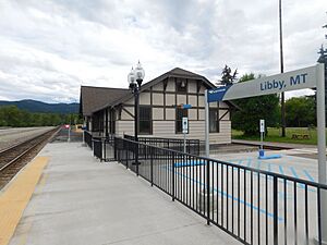
- Amtrak trains stop at the local station in Libby.
- U.S. Route 2 and Highway 37 meet in the center of town.
- Libby Airport is a public airport located 7 miles (11 km) south of the city.
Notable People from Libby
Many interesting people have come from Libby, including:
- Steve Gunderson, a politician in Montana.
- Ralph Heinert, an engineer and politician in Montana.
- Ryggs Johnston, a golfer.
- John Lovick, a magician.
- Scott MacDonald, an actor.
- Destiney Sue Moore, a television personality.
- Duane Nellis, who became president of Ohio University.
- Marc Racicot, a former Governor of Montana and chairman of the Republican National Committee.
- Keith Tower, a former NBA basketball player.
See also
 In Spanish: Libby (Montana) para niños
 | DeHart Hubbard |
 | Wilma Rudolph |
 | Jesse Owens |
 | Jackie Joyner-Kersee |
 | Major Taylor |


