North Fork Flathead River facts for kids
The North Fork Flathead River is a long river, about 153 miles (246 km) long, that starts in British Columbia, Canada. It then flows south into the state of Montana in the United States.
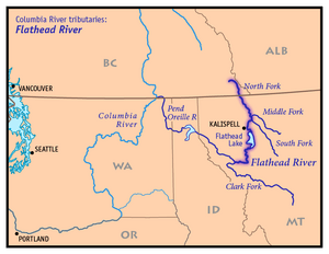
This river is one of the three main "forks" or branches that come together to form the larger Flathead River. The Flathead River then flows into Flathead Lake. Eventually, its waters join the Columbia River through other rivers like the Clark Fork River and the Pend Oreille River. People sometimes call the North Fork the "upper headwaters" of the Flathead River, meaning it's where the Flathead River really begins.
Quick facts for kids North Fork Flathead River |
|
|---|---|

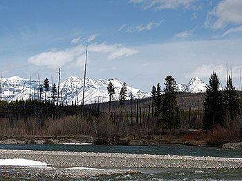
The river at the boundary of Glacier National Park
|
|

Map of the Flathead River drainage basin showing the North Fork
|
|
| Other name(s) | North Fork of Flathead River, North Fork of the Flathead River |
| Country | Canada, United States |
| Province | British Columbia |
| State | Montana |
| City | West Glacier, Montana |
| Physical characteristics | |
| Main source | Clark Range British Columbia, Canada 49°19′56″N 114°51′09″W / 49.33222°N 114.85250°W |
| River mouth | Flathead River 3,120 ft (950 m) 48°28′02″N 114°04′09″W / 48.46722°N 114.06917°W |
| Length | 153 mi (246 km) |
| Basin features | |
| Basin size | 1,560 sq mi (4,000 km2) |
| Tributaries |
|
Contents
Where Does the River Flow?
The North Fork Flathead River starts in a valley in the Clark Range mountains. This area is northeast of Lake Koocanusa in British Columbia, Canada.
First, the river flows west. Then, it reaches the Continental Divide, which is like a big mountain ridge that separates which ocean rivers flow to. At this point, the river turns and starts flowing south.
Journey Through Glacier National Park
As the river continues south, it winds through a wide valley shaped by glaciers long ago. It then crosses the border into Montana, USA. Here, it forms the western edge of Glacier National Park.
The river twists and turns past several beautiful lakes inside or near the park. These include Kintla Lake, Bowman Lake, Quartz Lake, Logging Lake, and Lake McDonald.
After passing these lakes, the river turns west and then south again. It enters a narrower valley before meeting another important river, the Middle Fork Flathead River. This meeting point is close to the southwest entrance of Glacier National Park.
Just a few miles downstream from this meeting, the combined river joins the South Fork Flathead River. When all three forks come together, they officially form the main Flathead River.
Why is This River Special?
The North Fork Flathead River is very important for its natural beauty and clean water.
Wild and Scenic River Status
In the United States, a part of the North Fork is protected as a National Wild and Scenic River. This means it's kept in its natural, free-flowing state. This special status was given in 1975.
However, a longer part of the river in British Columbia, Canada, does not have this same protection. Even so, the water in the Canadian section stays very clean. This is because there are no towns or farms with animals along that part of the river.
Protecting the River from Dams
Many years ago, in the 1940s, there was a plan to build a large dam called the Glacier View Dam on the river. This dam would have flooded a big part of the river's valley, including land inside Glacier National Park.
People who lived in the Flathead Valley supported the dam. But the National Park Service strongly opposed it. They were worried about losing thousands of acres of park land to the floodwaters. Luckily, the plan for the dam was stopped by 1950, keeping the river wild and free.
 | Claudette Colvin |
 | Myrlie Evers-Williams |
 | Alberta Odell Jones |

