Middle Fork Flathead River facts for kids
Quick facts for kids Middle Fork Flathead River |
|
|---|---|

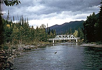
The river near Essex, Montana
|
|

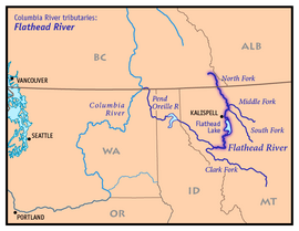
Map of the Flathead River watershed showing the Middle Fork
|
|
| Country | United States |
| State | Montana |
| Cities | West Glacier, Montana, Essex, Montana |
| Physical characteristics | |
| Main source | Bob Marshall Wilderness Montana, United States 47°59′47″N 113°03′30″W / 47.99639°N 113.05833°W |
| River mouth | Flathead River Montana, United States 3,120 ft (950 m) 48°28′01″N 114°04′09″W / 48.46694°N 114.06917°W |
| Length | 92 mi (148 km) |
| Basin features | |
| Basin size | 1,160 sq mi (3,000 km2) |
The Middle Fork Flathead River is a beautiful river in western Montana, United States. It stretches about 92 miles (148 km) long. This river forms the edge of the famous Glacier National Park on its southwest side. It's an important part of the Flathead River system.
The river's water comes from an area called a drainage basin. This basin is located to the east of the South Fork Flathead River. It is also near the Hungry Horse Reservoir. Several towns are located along the river. These include West Glacier, Nyack, Pinnacle, Essex, and Nimrod.
Contents
Where the River Starts and Flows
The Middle Fork Flathead River begins in a wild area called the Bob Marshall Wilderness. It starts where two smaller streams, Strawberry Creek and Bowl Creek, meet. From this point, the river flows north.
Journey Through Glacial Valleys
As it travels, the river collects water from many smaller streams. These streams flow from valleys that were carved by glaciers long ago. Most of these valleys are inside Glacier National Park. The river then starts to run alongside U.S. Highway 2. It winds its way north-northwest.
Changing Landscapes
After flowing through a long, narrow path, the river enters a wider valley. Here, it spreads out and forms many smaller channels, weaving between meadows and forests. Then, it enters another narrow gorge. The river generally turns westwards at this point. It passes the southwest entrance of Glacier National Park.
Joining Other Rivers
Near the park entrance, the Middle Fork receives water from a large glacial lake called Lake McDonald. This lake feeds into the river from the right side. The river then continues southwest. It eventually meets the North Fork Flathead River. This meeting point is southwest of West Glacier. It is also northeast of Columbia Falls.
When the Middle Fork and North Fork meet, they form the main part of the Flathead River. The Flathead River then flows into the Clark Fork River. The Clark Fork River eventually becomes the Pend Oreille River.
 | Jackie Robinson |
 | Jack Johnson |
 | Althea Gibson |
 | Arthur Ashe |
 | Muhammad Ali |

