Bad Rock Canyon facts for kids
Quick facts for kids Bad Rock Canyon |
|
|---|---|

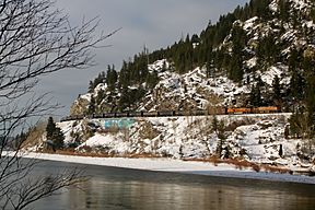
A view of the Flathead River flowing west through Bad Rock Canyon and a BNSF eastbound oil train.
|
|
| Floor elevation | approx. 2,910 feet (900 m) |
| Length | 2.75 miles (4.43 km) |
| Width | .25 to .50 miles (0.40 to 0.80 km) |
| Geography | |
| Rivers | Flathead River |
Bad Rock Canyon is a cool river canyon in Montana, USA. It's about 2.64 miles (4.25 km) east of Columbia Falls, Montana. The Flathead River flows through this canyon. Next to the river, you'll find U.S. Highway 2. This highway helps people travel through the canyon. The canyon leads into Montana's Flathead Valley. Sometimes, Rock slides happen on the northern side of the canyon. These slides are near the BNSF Railway tracks.
Contents
History of Bad Rock Canyon
For a very long time, Bad Rock Canyon was an important path. It was part of a trail that buffalo used. This trail went through the Rocky Mountains. It led to big hunting grounds on the Great Plains.
The towns closest to the canyon today are Hungry Horse and Martin City. They are just east of the canyon. The town of Coram is a bit further northeast. It's only about 5 miles from the western entrance of Glacier National Park.
Native American Buffalo Hunts
Many Native American tribes used Bad Rock Canyon. Tribes from the plateau, like the Kalispel and Pend d'Oreilles, traveled through it. The Spokane, Coeur d'Alene, and Kootenai tribes also used this path. The nearby Flathead tribe also passed through here. They all used the canyon for their buffalo hunts.
Plains tribes, mainly the Blackfeet, also came through the area. They wanted to get good horses from the western tribes. Stories passed down through generations suggest that some battles might have happened in the canyon.
Your Gateway to Wilderness Areas
Bad Rock Canyon is like a special entrance. It leads to amazing wilderness areas. These include the Bob Marshall Wilderness and the Hungry Horse Dam. There's also the Hungry Horse Recreation Area. And of course, it's a way to get to Glacier National Park.
Along U.S. Highway 2 in the canyon, there's a pull-off area. It has interesting water features. They look especially cool when they are frozen in winter. On the south side of the canyon, there is a spring. Many local people use this spring as a source for their water.
Understanding Rock Slides
Rock slides happen often on the northern side of the canyon. This is where the BNSF Railway tracks are. The railroad has put in special Railway slide fences. These fences help detect slides. They also help stop rocks from damaging the tracks or hitting trains.
Rock slides can also happen on the U.S. Highway 2 side. But they happen less often there. This is because people have worked to make the rock formations more stable.
 | Delilah Pierce |
 | Gordon Parks |
 | Augusta Savage |
 | Charles Ethan Porter |


