
Mission Mountains facts for kids
- This article is for the mountain range in Montana. For the small mountain range in British Columbia, Canada, also known as Mission Mountain, see Mission Ridge (British Columbia). For the summit in California see Mission Peak.
Quick facts for kids Mission Mountains |
|
|---|---|
| Mission Range "The Missions" |
|

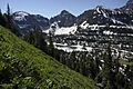
Looking towards McDonald Peak, high point of the Mission Mountains, rising above McDonald Lake
|
|
| Highest point | |
| Peak | McDonald Peak |
| Elevation | 9,820 ft (2,990 m) |
| Geography | |
| Country | United States |
| State | Montana |
The Mission Mountains or Mission Range are a group of mountains in the Rocky Mountains. You can find them in northwestern Montana, United States. These mountains are mostly in Lake County and Missoula County. They are located south and east of Flathead Lake and west of the Swan Range. To the east of the mountains is the Swan River Valley, and to the west is the Mission Valley.
The tallest point in the Mission Mountains is McDonald Peak, which stands at 9,820 feet (2,990 m) high. The mountains get their name from the nearby St. Ignatius Mission. This mission was started by Jesuit priests in the mid-1800s in what is now St. Ignatius, Montana.
Contents
Discover the Geology of the Mission Mountains
The Mission Mountains are mostly made of a type of rock called "Belt Rock." This rock comes from something huge called the Belt Supergroup. The sedimentary rocks you see here formed a very long time ago, between 1.47 and 1.4 billion years ago! They formed in a giant bowl-shaped area called the Belt Basin. This basin collected dirt and sand from nearby areas for millions of years.
Later, this basin was buried deep underground. Then, about 80 million years ago, huge pieces of the Earth's crust, called tectonic plates, crashed into each other. This collision pushed the buried rock back up to the surface, forming the mountains we see today.
Much of the Belt Rock in the Mission Mountains is a crumbly sedimentary rock called mudstone. This mudstone often has mudcracks. This tells us it formed when wet mud dried out and cracked, then got covered by new wet mud that also dried and cracked, over and over again.
Most of the rocks in the Mission Mountains are from the end of the Proterozoic Eon. This was near the end of what we call Precambrian time. Because these rocks are so incredibly old, the only signs of life found in them are old algae blooms and very simple plant fossils. But these tiny organisms were super important! They helped turn carbon dioxide in the water into oxygen, which slowly changed the Earth's early atmosphere.
The color of the mudstone in the Missions depends on a mineral called hematite. Hematite forms when iron bits react with oxygen in the air. Green and gray rocks likely formed in deep water. Red rocks probably formed in shallower water. You can also find ripple marks in many of the rocks. These marks formed in shallow water with gentle waves.
How the Mountains Rose: Uplift

The way the Mission Mountains look today was shaped a lot by the last few ice ages. The most recent one ended just over 10,000 years ago. But the mountains also have a much longer story! It started when the super-continent Pangaea began to break apart. As the continents moved, the North American Plate slowly slid westward. It scraped against the Pacific Plate. This process, called subduction, caused the Rocky Mountains to rise, including the Missions.
About 66 million years ago, this mountain-building process started to slow down. This time is called the Cenozoic Era. During this era, the area began to look much like it does today. The continents were in their current positions, and the plants and animals would be familiar to us. However, the deep valleys of western Montana had not yet formed.
These valleys likely appeared about 40 million years ago. The same forces that lifted the Rockies began to stretch and crack the Earth's crust. Almost straight up-and-down cracks, called faults, formed across the region. These faults mostly ran from northwest to southeast. Then, huge blocks of land broke apart. Some blocks dropped down, creating valleys like the Flathead and the Swan. This whole process took about 100 million years!
Ice Age Sculpting: Pleistocene Glaciation
Three million years ago, at the end of the Cenozoic Era, western Montana had tall mountains. But the next big geological event truly shaped them. Huge glaciers began to form in the area about 2 to 3 million years ago. This was the start of the Pleistocene Epoch. From then until about 10,000 years ago, the Mission Mountains were carved by ice and water.
The formation of the Flathead Lobe glacier started this process. This glacier was part of a larger ice sheet. At its thickest, the Flathead Lobe glacier might have been 4,000 feet taller than the valley floor! It stretched for hundreds of miles down the Rocky Mountain Trench, reaching as far south as St. Ignatius, Montana. At the northern end of the Mission Range, the glacier split. Part of it slowly flowed into the Swan Valley.
Imagine looking at the area back then! Huge glaciers flowed around both sides of the range and even partly over it. Smaller glaciers also flowed out of the mountains and joined the bigger ones in the valleys. This explains the hook-shaped ridges at the end of each canyon in the range, which point southward.
These ice age processes also gave the Mission Mountains their unique shapes. Many peaks have three sharp sides, called horns or pyramidal peaks. The knife-like ridges in the southern half of the range are also results of heavy mountain glaciation. The northern half of the range was largely smoothed over by the Flathead Lobe. This was like a giant, moving ice sheet. This led to the shorter, more rounded features you see in the northern part of the mountains.
The Pleistocene was a time of fast and dramatic shaping in the Mission Mountains. Even though that ice age has ended, the erosion continues. Rain, snow, ice, wind, and other forces are still working on the high mountain landscape of the Missions.

Human History in the Missions
People have been in contact with the Mission Mountains for thousands of years. The Salish and Kootenai people have traditionally used these mountains. They came here for fishing, hunting, picking berries, and for important sacred ceremonies.
The Mission Mountains first got a lot of outside attention in the 1920s. Theodore Shoemaker, who worked for the Forest Service, led groups of visitors through the mountains. This happened between 1922 and 1924. One group included people from the Great Pacific Railway Company, which owned a lot of land in the area. On a trip in 1923, Shoemaker used triangulation to figure out where several peaks were. This led to the very first map of the high country.
In the 1930s, people thought about making the Mission Mountains part of a new national park. This park would have been south of Glacier National Park. J. L. Jones, the president of the Ronan Commercial Club, wrote to the National Park Service director. He said, "We suggest, Mr. Albright, that you add to your already splendid services the inclusion of the Mission Range of mountains... Truly we possess here not the 'garden of Eden,' but that being lost only in myth and tradition we have a most fitting substitute 'The Garden of the Rockies.'"
The park service sent a team to study the area in the summer of 1937. But in the end, they decided not to include the Missions. They wrote that the Flathead area would be special for a national park, but it was already similar to Glacier Park.
The first big step to protect the Mission Range happened on October 21, 1931. On that day, 67,000 acres of land along the east side of the Mission Divide were set aside as the Mission Mountains Primitive Area. The Great Pacific Railway Company owned 30 percent of this land at the time. Over the years, they traded this land for other land in the Flathead National Forest.
You can learn more about the Mission Mountains and the area around them in local books. Two of these are In the Shadows of the Missions and Indian Trails and Grizzly Tales.
Hiking and Fun in the Missions
Most of the Mission Mountains are specially protected. This means that land use is mainly for fun activities like hiking and exploring.
The best time to hike in the Mission Mountains is from early July to October. Winter lasts late in the high mountains. Even in early July, you might find high passes and lakes covered in snow and wet. Snow can start falling as early as October, and the hiking season usually ends by the end of that month.
Winter fun is best in the spring months. June is often wet. But between February and May, you can enjoy great winter camping, snowshoeing, and skiing.
If you're new to hiking here, know that only a few trails are "easy." The land, especially in the south, is very steep. Trails are not always kept perfectly clear. If you leave the trail and try to climb the rocks, you'll quickly find that 1.5-billion-year-old mudstone is very crumbly. It's not a very safe rock to hold onto. Always climb with care.
During the day, it can get very hot, but nights are very cold. So, pack clothes for both warm and cold weather. Even though the Missions aren't huge, it's always a good idea to bring a map. You can find USGS maps of the area at local sporting goods stores. It's smart to have one in your backpack.
Because the Mission Range is a protected wilderness area, certain vehicles are not allowed. This includes motorized trail bikes, motorcycles, three- and four-wheelers, snowmobiles, hang-gliders, and mountain bikes. If you are caught with one, you will get a ticket.
The range has about 45 miles of official trails. Experienced hikers can also find many animal and old Native American trails. These often cut through the tougher parts of the mountains. Horses can be used on most official trails and some others. However, the Missions are rough for horses. Before riding here, you should talk to local experts. People who want to take horses into the range need to check the Flathead National Forest rules. These include rules about hay and other things.

If you are not a member of the Confederated Salish and Kootenai Tribes and you pass through their land, you need a valid tribal lands-usage permit. You can easily get this pass at local sporting goods stores. The pass is good for one year. It allows you to access the Mission Mountains, parts of the Flathead River, and other areas.
Protected Areas in the Mountains
The Mission Mountains have several different layers of protection. A large part of the Mission Mountain Range is managed by the Confederated Salish and Kootenai Tribes of the Flathead Nation.
Most of the range is also part of the Flathead National Forest. Within this forest, the Mission Mountains Wilderness is a special wilderness area. This wilderness area is in the Swan Lake Ranger District. It covers 73,877 acres. It was made a wilderness area on January 4, 1975, and is managed under the Wilderness Act of 1964.
The southern end of the Mission Mountains includes a large area protected for grizzly bears. This area is usually closed to hikers from July through September. This closure allows the bears to eat ladybugs and cutworms. It also helps keep bears and humans from meeting each other too often.
Amazing Animals and Plants: Ecology

The Mission Mountains are home to a wide variety of plants and animals. Many large animals have been seen here. These include mule deer, elk, white-tailed deer, mountain goats, moose, black bears, grizzly bears, coyotes, wolverines, lynxes, bobcats, and mountain lions.
Smaller animals found in the Missions include hoary marmots, yellow-bellied marmots, snowshoe rabbits, pikas, chipmunks, squirrels, porcupines, muskrats, badgers, skunks, beavers, martens, weasels, and mink.
Western Montana's famous huckleberry is also found all over the slopes of the Mission Mountains. You can find them in mid to late summer. They are a favorite snack for both hikers and grizzly bears!
The most common trees in the range are the ponderosa pine, western red cedar, douglas fir, western larch, western white pine, lodgepole pine, limber pine, whitebark pine, Engelmann spruce, alpine fir, grand fir, western larch, quaking aspen, alder, and Rocky Mountain maple. Cedars often grow near creek bottoms, while other trees are spread throughout the landscape.
Higher up in the Missions, you'll find the alpine larch. This tough little tree grows between about 6,500 feet and 7,000 feet high. You can see it all over the range, twisted and tangled along high ridges and around the peaks.
Cool Features of the Mission Mountains
Here are some of the major peaks you can find in the Mission Mountains: Daughter-of-the-Sun Mountain, Flat-Top, Glacier Peak, Gray Wolf Peak, Kakashe Mountain, McDonald Peak, Mount Calowahcan (which used to be called Mt. Harding), Mountaineer Peak, Sonyelm, and West and East St. Mary's Peaks.
Many beautiful lakes are also found in the range. These include: Ashley Lakes, Cold Lakes, Lake of the Stars, Lost Sheep Lake, Lucifer Lake, McDonald Lake (which is a reservoir), Mud Lakes, Mullman Lakes, Rainbow Lake, Schwarz Lake, Summit Lake, and Terrace Lake, among others.
Images for kids
-
A view of Mullman Lakes in the Mission Mountains in western Montana. Out of the frame, to the right is Mount Calowahcan.

