Mission Peak facts for kids
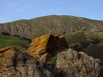
Quick facts for kids Mission Peak |
|
|---|---|
 |
|
| Highest point | |
| Elevation | 2,520 ft (768 m) NAVD 88 |
| Naming | |
| Native name | Riisima (Northern Ohlone) |
| Geography | |
| Location | Alameda County, California, U.S. |
| Parent range | Diablo Range |
| Topo map | USGS Niles |
| Climbing | |
| Easiest route | Peak Trail or Hidden Valley Trail |
Mission Peak Regional Preserve is a fun public park located east of Fremont, California. It's managed by the East Bay Regional Park District. This park is the northernmost peak on a ridge that also includes Mount Allison and Monument Peak. Mission Peak is very important to the city of Fremont. You can even see it on the city's logo!
| Top - 0-9 A B C D E F G H I J K L M N O P Q R S T U V W X Y Z |
Exploring Mission Peak: Hiking and Biking
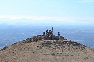
Mission Peak is a super popular spot for people who love the outdoors! It's right next to Silicon Valley and offers amazing views. Hikers, bicyclists, and sightseers from all over the Bay Area come here. Many tourists visit too, just to see the incredible sights and enjoy the challenging climb.
The "Mission Peeker" marker pole at the very top is the most famous spot in Fremont. Thousands of visitors take photos with it every week! The entrance at Stanford Avenue gets up to 2,000 visitors on weekends. Since 2010, even more people have started visiting, making it Fremont's top attraction.
Trails and Safety Tips
A full trip up and down the main trail is about six miles (10 km). It usually takes walkers two to five hours. Bicyclists and runners can do it faster, in about one to one-and-a-half hours.
It's important to be careful, especially when the sun is strong. People can get dehydrated if they don't drink enough water. Experts suggest carrying two liters of water per person. If you bring your dog, make sure to bring extra water for them too! Also, always use sun protection like hats and sunscreen.
You'll see signs that ask you not to take shortcuts off the trails. This is because shortcuts can cause the ground to wear away, which is called erosion. Some shortcut areas even have barbed wire fences to stop people from going off the path.
Starting Your Adventure
There are three main trails that go up the mountain. Two popular trails, the Hidden Valley Trail and the Peak Meadow Trail, start from Stanford Avenue. These trails climb about 2,100 feet (640 m) up the mountain. They offer amazing views of the Bay Area, but there's not much shade, so it can be very sunny. The Stanford Avenue entrance has water and restrooms, but you can't buy food or drinks there.
The park also suggests using the Mission Peak Trail, which starts at Ohlone College. This trail also climbs about 2,100 feet (640 m) and is a bit longer than the Hidden Valley Trail. The Ohlone College entrance has restrooms and a water fountain. Parking at Ohlone College is usually easy to find.
Most people get to the park using freeways 680 and 880. You can also use public transport! The Warm Springs BART station and AC Transit buses can take you to Ohlone College.
Other Routes to the Top
Two less common ways to reach Mission Peak start from Sunol Regional Wilderness and Ed R. Levin County Park in Milpitas.
The Sunol route is about five miles (8 km) long and climbs 2,200 feet (670 m). It's not as steep as the Hidden Valley Trail. The route from Levin County Park first climbs 2,200 feet (670 m) to Monument Peak. From there, Mission Peak is another three miles (5 km) away on a mostly flat trail. This path goes past Mount Allison, which is the tallest of the three peaks, but it's not open to the public.
What You Can See From the Top
On clear days, you can see other famous Bay Area peaks like Mount Diablo, Mount Hamilton, and Mount Tamalpais. You'll also get great views of cities like Oakland, San Jose, San Francisco, Fremont, and Newark. On very clear days, you might even see the Sierra Nevada mountains, which are 100 miles (160 km) to the east!
Mission Peak is also part of a bigger network of trails. It includes a section of the Bay Area Ridge Trail, which is still being built. There's even a campsite called Eagle Spring Backpack campsite just east of the summit.
The Famous "Mission Peeker" Pole
The well-known "Mission Peeker" pole was put up on December 27, 1990. A sculptor named Leonard Page and a team of six people created it. The pole is over six feet (1.8 m) tall, and its base is two feet (0.6 m) deep, held in place with 120 pounds (54 kg) of concrete.
The Peeker's Original Message
The artist wanted the pole to help people think about protecting our environment. The sticks on the pole represent different parts of environmental recycling. Inside the steel tube, there are some special items:
- A crystal used in traditional cultures.
- A copy of an Ohlone charmstone.
- A bottle of 1990 zinfandel wine, whose yeast growth shows how the world's population has grown.
- Five time capsules filled with articles and photos.
These time capsules were meant to be opened after the year 2090. They contain information about saving rainforests, AIDS, and homelessness. They also have pictures from popular culture, like Bart Simpson, Teenage Mutant Ninja Turtles, and Gary Larson's Far Side cartoons.
How the Peeker is Used Today
The meaning of monuments can change over time, and the "Mission Peeker" is a good example. It was designed in 1988 to be an "interpretive post" with tubes pointing to other landmarks. However, its original purpose isn't widely known anymore.
Today, the pole is seen as a special cultural symbol on its own. Thousands of sightseers and tourists visit it every week. It's the most photographed object in southern Alameda County and the top tourist spot in Fremont. If you use Snapchat, you might even see a special filter of the pole that represents Fremont!
Because it's so popular, the pole has also become a topic of discussion. In 2014, some local residents and park officials talked about removing the landmark. They thought it might help reduce the huge number of visitors.
Flying High: Hang Gliding and Paragliding
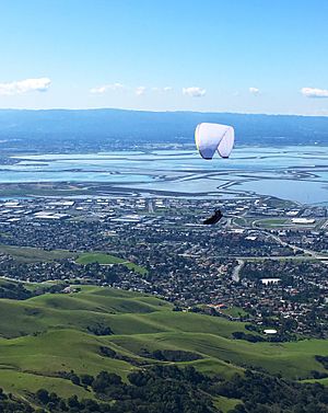
Mission Peak Regional Preserve is a fantastic place for hang gliding and paragliding!
The Wings of Rogallo Northern California Hang Gliding Association Inc. has been allowed by the East Bay Regional Park District to manage these activities since 1983.
Hikers can watch the gliders take off from a special spot that's 1,950 feet (594 m) above sea level. You'll see a large wind sock there. The gliders land near the main hiking trail, about a quarter-mile (400 m) from the Stanford Avenue entrance.
A very important event happened here on September 6, 1971. Dave Kilbourne, one of the founders of the Wings of Rogallo, hiked to the top of Mission Ridge. He then launched a flex-wing hang glider all by himself! His flight lasted over an hour, making him the first person in the world to do such a thing.
Mission Peak's Environment: Plants and Animals
Mission Peak is home to different types of plants, including California oak woodland and chaparral. The woodland areas have trees like coast live oak, California bay, California buckeye, blue oak, and western sycamore. Black oak trees are rare because most were cut down a long time ago.
You might also see Bigleaf maples and gray pines, though they are less common. In a special area called A.A. Moore Memorial Grove, you can find very old oak trees, some 100 to 600 years old!
The steepest parts of the mountain are covered in tough, evergreen chaparral plants. These include California sagebrush, chamise, and scrub oak.
Wildlife You Might See
The grasslands have both native wildflowers and plants brought by cows. You might see cattle grazing, and they can be quite feisty! Black-tailed deer are very common here.
Long ago, Pronghorn and tule elk used to live here but disappeared in the late 1800s. Now, tule elk sometimes visit Alameda County again.
Predators in the area include bobcats, coyotes, and gray foxes. It's very rare to see mountain lions. Smaller animals you might spot are black-tailed jackrabbits, western gray squirrels, and California ground squirrels.
Important Safety Tip: Be aware that northern Pacific rattlesnakes are very common in this area. Always watch where you step!
Southern Alameda County has many golden eagles nesting, so you'll often see them flying around. Other birds of prey include turkey vultures, red-tailed hawks, red-shouldered hawks, prairie falcons, and sharp-shinned hawks. They build their nests on the steep slopes where there are no trails.
Weather at Mission Peak
Light snow falls most winters but usually melts quickly. Heavy snow is rare, happening only once or twice every ten years. For example, there was a big snowfall in March 2006 (you can see a picture in the Hiking and Bicycling section). On December 7, 2009, snow fell as low as 1,000 feet (300 m) and stayed for three days!
How Mission Peak Was Formed
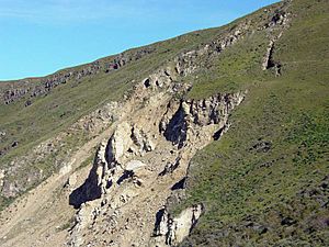
Mission Peak has a very large landslide area, about 300 meters wide and 1,200 meters long. This landslide started in 1998 because of heavy rains from El Niño. Landslides have happened in this spot many times in the past. This event even led to new rules for building homes nearby to make sure they are safe from such natural events.
Some people have mistakenly thought Mission Peak was an extinct volcano because of its pointy shape. However, the mountain was actually formed by natural uplift and erosion, not by volcanic activity. This mountain range is being pushed up and squeezed because it's located between two major fault lines: the Hayward Fault to the west and the Calaveras Fault to the east.
 | Anna J. Cooper |
 | Mary McLeod Bethune |
 | Lillie Mae Bradford |


