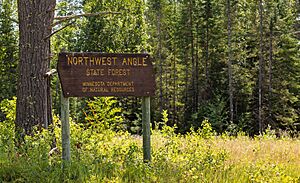
Northwest Angle facts for kids
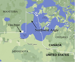
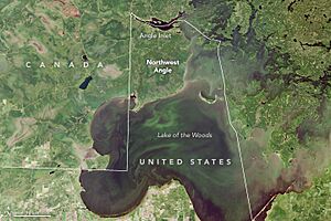
The Northwest Angle, often called the Angle by people who live there, is a unique part of northern Minnesota. It's a piece of land that is separated from the rest of Minnesota by Lake of the Woods. This means you have to travel through Canada or cross the lake to reach it from other parts of the United States.
The Northwest Angle is special because it's the only place in the main 48 states of the U.S. that is north of the 49th parallel. This line usually forms the border between the U.S. and Canada. It's like a small island of U.S. land that's almost completely surrounded by Canada and a big lake. The small town of Angle Inlet is located here.
Most of the land in the Angle (about 70%) is held by the Red Lake Indian Reservation (Ojibwa). Even though it's a distinct area, not many people live there. In 2010, only 119 people called it home. The area is mostly water and thick forests.
Contents
Why is the Northwest Angle There?
The Northwest Angle exists because of a mistake made a long time ago. When the first border between Canada and the United States was being decided, the people making the decisions didn't have accurate maps.
In 1783, after the American Revolutionary War, the Treaty of Paris was signed. Benjamin Franklin and British leaders used a map by John Mitchell. This map showed Lake of the Woods as a round lake. It also didn't correctly show where the Mississippi River started. The treaty said the border would go "through the Lake of the Woods to the northwesternmost point thereof, and from thence on a due west course to the river Mississippi..."
However, the Mississippi River actually starts far to the south, not to the north and west of the lake. Also, Lake of the Woods isn't round; it has a very irregular shape. This made finding its "northwesternmost point" tricky.
Over the years, several agreements and surveys tried to fix this. In 1818, the Anglo-American Convention of 1818 decided the border would go north or south from the lake's northwest point to the 49th parallel, and then west along that parallel.
Finally, in 1842, the Webster–Ashburton Treaty confirmed the border. It set the exact location of the lake's northwesternmost point. Because of where this point was, and the lake's shape, a small piece of U.S. land was cut off to the east. This isolated piece of land became known as the Northwest Angle.
What is the Geography Like?
The Northwest Angle is mostly water. Out of its total area of about 596 square miles (1,544 square kilometers), only about 123 square miles (319 square kilometers) is land. The rest is water from Lake of the Woods.
The land includes several islands, like Oak Island. There are also two small points of land, called capes, that are south of the 49th parallel. One of these is Elm Point. Most of the people who live in the Angle live on the mainland, but some live on the islands.
The Northwest Angle is also home to the very last one-room public school in Minnesota.
How to Get to the Angle
Getting to the Northwest Angle from the rest of Minnesota is an adventure! There are two main ways:
- By Water or Air: You can cross Lake of the Woods by boat when there's no ice. In winter, when the lake freezes, people can use an ice road. You can also fly there in a plane. There are no car ferries, so you can't drive across the lake unless it's winter and the ice road is open. When the ice is forming or melting, it's not safe to cross, so flying is the only way to get there from Minnesota without going through Canada. During the COVID-19 pandemic, a special toll ice road was opened to help people reach the Angle without crossing into Canada.
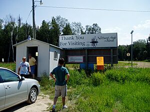
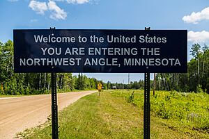
- By Land (through Canada): To drive to the Angle from the rest of Minnesota, you have to enter Canada first! You take Minnesota State Highway 313 into Manitoba, Canada. Then you drive on Canadian roads (Provincial Road 308 and Provincial Road 525). Finally, you cross back into the United States at the Northwest Angle. This drive is about 63 miles (101 kilometers) long, going through both Minnesota and Manitoba. The border crossing into the Angle is not staffed by agents. Instead, travelers use a special phone at places like Jim's Corner to contact Canadian or U.S. Customs and report their entry.
Who Lives in the Northwest Angle?
In 2010, only 119 people lived in the Northwest Angle. Most of them were White (99.2%), with one person identifying as Native American or Alaska Native.
The people living there are spread out in age. About 10% are under 18, and about 27.6% are 65 or older. The average age was 50 years old.
The average income for a family in the Angle was about $31,250. A small number of families (about 13.3%) lived below the poverty line.
What is the Climate Like?
The Northwest Angle has a climate with warm summers and cold, snowy winters. It gets very cold in winter, with temperatures often dropping far below zero. The average lowest temperature in winter is about -38°F (-39°C). The coldest temperature ever recorded there was -47.3°F (-44.1°C) in February 2002.
Summers are warm, but not usually extremely hot. The highest temperature ever recorded was 96.8°F (36°C) in July 1988. The area gets a good amount of rain in summer and about 48 to 54 inches (122 to 137 cm) of snow each year.
| Climate data for Northwest Angle, Elevation 1,096 ft (334 m), 1981-2010 normals, extremes 1981-2018 | |||||||||||||
|---|---|---|---|---|---|---|---|---|---|---|---|---|---|
| Month | Jan | Feb | Mar | Apr | May | Jun | Jul | Aug | Sep | Oct | Nov | Dec | Year |
| Record high °F (°C) | 46.7 (8.2) |
51.5 (10.8) |
74.0 (23.3) |
84.9 (29.4) |
90.4 (32.4) |
95.0 (35.0) |
96.8 (36.0) |
96.1 (35.6) |
93.4 (34.1) |
82.9 (28.3) |
69.3 (20.7) |
48.9 (9.4) |
96.8 (36.0) |
| Mean daily maximum °F (°C) | 13.4 (−10.3) |
20.4 (−6.4) |
32.5 (0.3) |
48.5 (9.2) |
62.5 (16.9) |
70.9 (21.6) |
76.3 (24.6) |
74.5 (23.6) |
64.4 (18.0) |
49.8 (9.9) |
32.6 (0.3) |
18.0 (−7.8) |
47.1 (8.4) |
| Daily mean °F (°C) | 3.4 (−15.9) |
9.5 (−12.5) |
22.0 (−5.6) |
38.2 (3.4) |
51.8 (11.0) |
61.3 (16.3) |
65.9 (18.8) |
64.4 (18.0) |
54.7 (12.6) |
41.5 (5.3) |
25.5 (−3.6) |
9.6 (−12.4) |
37.4 (3.0) |
| Mean daily minimum °F (°C) | −6.5 (−21.4) |
−1.4 (−18.6) |
11.4 (−11.4) |
27.8 (−2.3) |
41.1 (5.1) |
51.6 (10.9) |
55.4 (13.0) |
54.3 (12.4) |
44.9 (7.2) |
33.2 (0.7) |
18.4 (−7.6) |
1.1 (−17.2) |
27.7 (−2.4) |
| Record low °F (°C) | −45.2 (−42.9) |
−47.3 (−44.1) |
−29.4 (−34.1) |
−2.7 (−19.3) |
20.4 (−6.4) |
32.1 (0.1) |
36.7 (2.6) |
32.8 (0.4) |
24.5 (−4.2) |
4.8 (−15.1) |
−28.0 (−33.3) |
−35.9 (−37.7) |
−47.3 (−44.1) |
| Average precipitation inches (mm) | 0.91 (23) |
0.65 (17) |
0.91 (23) |
1.27 (32) |
2.97 (75) |
4.35 (110) |
3.68 (93) |
3.27 (83) |
2.76 (70) |
2.07 (53) |
1.32 (34) |
0.98 (25) |
25.14 (639) |
| Average relative humidity (%) | 83.0 | 80.5 | 73.1 | 61.4 | 62.0 | 70.4 | 74.6 | 75.3 | 77.2 | 76.9 | 85.3 | 87.7 | 75.6 |
| Average dew point °F (°C) | −0.6 (−18.1) |
4.7 (−15.2) |
14.7 (−9.6) |
26.1 (−3.3) |
39.2 (4.0) |
51.6 (10.9) |
57.6 (14.2) |
56.4 (13.6) |
47.7 (8.7) |
34.8 (1.6) |
21.7 (−5.7) |
6.7 (−14.1) |
30.2 (−1.0) |
| Source: PRISM | |||||||||||||
What is the Ecology Like?
The Northwest Angle is mostly covered by forests, especially Spruce and Fir trees. The area is very cold in winter, which means only certain plants can grow there. Spring flowers usually bloom in mid-May, and the leaves change color in late September.
The Angle in Books and Stories
The unique location of the Northwest Angle has inspired many writers:
- Ernie Pyle, a famous journalist, wrote about the Angle and its people in his book Home Country.
- The American writer Tim O'Brien set his popular novel In the Lake of the Woods (1994) in the Angle. His short story "On the Rainy River" also takes place there.
- William Kent Krueger's novel Northwest Angle (2011) is set in this area.
- The Danny Orlis series of Christian fiction books for young people were also largely set in the Northwest Angle.
See also
 In Spanish: Angle Inlet para niños
 | John T. Biggers |
 | Thomas Blackshear |
 | Mark Bradford |
 | Beverly Buchanan |


