Lake of the Woods facts for kids
Quick facts for kids Lake of the Woods |
|
|---|---|

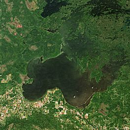
Lake of the Woods from space, September 2018
|
|
| Location | North America |
| Coordinates | 49°14′59″N 94°45′03″W / 49.24972°N 94.75083°W |
| Lake type | Glacial |
| Primary inflows | Rainy River Shoal Lake Kakagi Lake |
| Primary outflows | Winnipeg River |
| Basin countries | Canada and United States |
| Max. length | 68 mi (109 km) |
| Max. width | 59 mi (95 km) |
| Surface area | 1,679 sq mi (4,348.6 km2) |
| Max. depth | 210 ft (64 m) |
| Shore length1 | excluding islands: 25,000 mi (40,000 km) including islands: 65,000 mi (105,000 km) |
| Surface elevation | 1,056 ft (322 m) |
| Islands | 14,632 |
| Settlements | Angle Inlet, Minnesota Warroad, Minnesota Lake of the Woods, Ontario |
| 1 Shore length is not a well-defined measure. | |
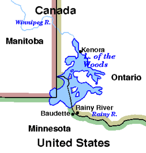
Lake of the Woods (which means lac des Bois in French) is a large lake in North America. It is located in parts of Ontario and Manitoba in Canada, and in the state of Minnesota in the United States.
This lake is special because it separates a small piece of Minnesota, called the Northwest Angle, from the rest of the United States. To get to the Northwest Angle from other parts of Minnesota, you have to cross the lake or travel through Canada. The Northwest Angle is the northernmost point of the contiguous United States (the main part of the U.S. without Alaska or Hawaii). Its "northwesternmost point" was an important landmark when the border between Canada and the U.S. was decided.
Lake of the Woods gets its water from rivers like the Rainy River, Shoal Lake, and Kakagi Lake. The water then flows out into the Winnipeg River, which eventually leads to Lake Winnipeg. From there, the water travels north through the Nelson River and finally reaches Hudson Bay.
The lake is huge, stretching over 70 miles (110 km) long and wide. It has more than 14,552 islands and an amazing 65,000 miles (105,000 km) of shoreline. Lake of the Woods is the sixth largest freshwater lake that is partly in the United States, after the five Great Lakes. It is also the 36th largest lake in the world by its size.
The many islands in the lake are important homes for different animals. Birds like the piping plover and many American white pelicans build their nests here. In the past, boreal woodland caribou also used the islands to have their babies. Today, hundreds of bald eagles also nest in this area.
The name "Lake of the Woods" comes from the French name lac des Bois, which means "lake of the woods" because of all the trees around it. However, it might have been a mistake when translating the original Ojibwe name. One Ojibwe name for the lake is Babiikwaawangaa-zaagaʼigan, which means "Lake with Uneven Sand," referring to the sand dunes found there.
Contents
Managing Lake Levels
In the early 1900s, people worried about the water levels in Lake of the Woods. Dams were built near Kenora, which affected how high or low the water got. To solve this, the governments of Canada and the United States asked the International Joint Commission (IJC) for help in 1912.
The IJC suggested creating special groups to manage the lake's water levels. The first group, called the Lake of the Woods Control Board (LWCB), was set up by Canada in 1919. This board now has members from Canada, Ontario, and Manitoba.
Later, in 1925, Canada and the United States signed a treaty. This treaty set rules for how high and low the lake's water levels should be. It also created an International Lake of the Woods Control Board (ILWCB). The Canadian LWCB manages the lake day-to-day, but its decisions need approval from the ILWCB if water levels go too high or too low. If the Canadian and American members of the ILWCB don't agree, the IJC makes the final decision.
Shoal Lake, which is next to Lake of the Woods, is where the city of Winnipeg gets its drinking water. Because of this, the governments of Winnipeg and Manitoba are very interested in how the lake is managed.
Communities Near Lake of the Woods
Many towns and First Nations communities are located around Lake of the Woods.
Ontario
- Northwest Angle 33 First Nation
- Big Grassy First Nation
- French Portage Narrows
- Kenora
- Minaki
- Lake of the Woods
- Anishnaabeg of Naongashiing First Nation
- Naotkamegwanning First Nation
- Sioux Narrows-Nestor Falls
- Obashkaandagaang Bay First Nation
- Niisaachewan Anishinaabe Nation
- Ojibways of Onigaming First Nation
- Rainy River
- Northwest Angle 37 First Nation
- Anishinabe of Wauzhushk Onigum First Nation
Manitoba
- Middlebro
- Buffalo Point First Nation
Minnesota
Islands and Peninsulas in Lake of the Woods
Lake of the Woods is famous for its thousands of islands.
Aulneau Peninsula
The largest land area in Lake of the Woods is the Aulneau Peninsula. It's almost an island, connected to the mainland by a very small strip of land. A canal was once dug through this strip, making the Aulneau a true island, but it has since been filled in. Now, there's a portage (a place to carry boats over land) for smaller boats. The Aulneau Peninsula is about 20 miles (32 km) long and 10 miles (16 km) wide. It even has over eighty lakes of its own, with the largest being Arrow Lake.
The Aulneau Peninsula is named after Father Jean-Pierre Aulneau, a French Catholic priest. He was killed on Lake of the Woods in 1736. A church in Warroad, Minnesota, is named Father Aulneau Memorial Church in his honor.
Other Interesting Islands
- Big Island
- Bigsby Island
- Brush Island, Minnesota
- Chapel Island is about 15 km from Kenora. A chapel used to stand there. It was a resting place for Indigenous people traveling by canoe and a place where settlers tried to convert them. It also offered shelter during bad weather. The chapel is gone now.
- Copeland Island is also known as Camp Stephens, a YM-YWCA summer camp from Winnipeg.
- Flag Island, Minnesota
- Garden Island, Minnesota
- Little Oak Island, Minnesota
- Magnuson's Island is where the historic Fort St. Charles has been rebuilt.
- Massacre Island, Ontario is a small island in the middle of the lake. It might be the place where twenty French men and some Cree traders were killed by Sioux warriors in the 1700s. A large wooden cross marks the spot. This event led to many years of war between the Sioux and the Ojibway.
- Oak Island, Minnesota
- Penasse Island is home to American Point, which used to be the northernmost post office in the main part of the United States.
- Sultana Mine was a mine on an island in the northern part of the lake in the late 1800s. It closed after an accident. There are stories that the mine is haunted by the miners who worked there.
Fun and Recreation on Lake of the Woods
Tourism is a big part of the economy around Lake of the Woods. There are many fun things to do on the lake and in the nearby areas. Some parts of the lake are quite remote, but resorts and equipment rental places help visitors who don't have their own boats.
Camping
Zippel Bay State Park in Minnesota offers campsites, restrooms, a marina, and a beach. Both Minnesota and Ontario have official parks and campsites that you can find through their governments. If you like backcountry camping, you can find many spots on the lake's islands by boat. There's lots of wildlife, even on the smaller islands.
Many marinas and resorts around the lake offer places to stay and eat. They also rent houseboats, provide maps, and give advice on camping and fishing to help you enjoy the lake.
Fishing
Lake of the Woods is a great place for fishing! You can find many types of fish here, including walleye, northern pike, perch, sauger, crappie, panfish, smallmouth bass, largemouth bass, lake trout, lake sturgeon, and muskellunge.
Royal Lake of the Woods Yacht Club
The Royal Lake of the Woods Yacht Club is also located on the lake.
See also
 In Spanish: Lago de los Bosques para niños
 | Laphonza Butler |
 | Daisy Bates |
 | Elizabeth Piper Ensley |


