
Winnipeg River facts for kids
Quick facts for kids Winnipeg River |
|
|---|---|

Location of the mouth of the river in Manitoba; Lake of the Woods is the large lake at the bottom right of the main map
|
|
| Country | Canada |
| Provinces | |
| Physical characteristics | |
| Main source | Lake of the Woods Kenora District, Ontario 322 m (1,056 ft) 49°46′18″N 94°31′27″W / 49.77167°N 94.52417°W |
| River mouth | Lake Winnipeg Manitoba 217 m (712 ft) 50°37′54″N 96°19′13″W / 50.63167°N 96.32028°W |
| Length | 235 km (146 mi) |
| Basin features | |
| Basin size | 106,500 km2 (41,100 sq mi) |
The Winnipeg River is a Canadian river that flows from Lake of the Woods in Ontario to Lake Winnipeg in Manitoba. It travels about 235 kilometers (146 miles). The river's name means "murky water" in the Cree language.
The area of land that drains into the Winnipeg River is called its watershed. This watershed covers about 106,500 square kilometers (41,100 square miles). Most of this land is in Canada, but a smaller part is in northern Minnesota, United States.
This river has been an important route for thousands of years.
Contents
History of the Winnipeg River
Ancient Travel and Trade Routes
For thousands of years, Native peoples used the Winnipeg River as a travel route. Later, French and English explorers and traders also used it. They traveled the river to trade with First Nations for furs.
The Winnipeg River was the only major water route between what is now Ontario and southern Manitoba that was easy to travel by canoe. Other routes, like the Red River, were much longer or harder to cross.
Early European Explorers
La Vérendrye was one of the first European explorers to build fur trade forts along the river. These forts were set up near First Nations camps.
The Winnipeg River system, especially in Whiteshell Provincial Park, has many petroforms. These are ancient stone shapes made by Indigenous peoples. They show how important this area was for travel, trade, ceremonies, and settlements long ago.
The Fur Trade Era
The Winnipeg River was the main way to get from the Great Lakes to Western Canada before railroads were built. Once travelers reached Lake Winnipeg, they could go by canoe to the Rocky Mountains, the Arctic Ocean, or Hudson Bay.
This route was very important for the fur trade. Traders would carry their goods and canoes over difficult spots called portages. The Winnipeg River was known for having many of these portages.
In the late 1600s, French explorers began to reach the area. By the 1700s, French traders were building forts along the river. This helped them trade with First Nations and drew trade away from the Hudson's Bay Company.
After the British took over Canada, British traders, called "pedlars," continued the fur trade. They formed the North West Company. The Hudson's Bay Company then built its own trading posts to compete. The two companies later joined together in 1821.
The last major use of the river for large expeditions was in 1870. After 1885, the Canadian Pacific Railway connected eastern and western Canada, making the river less important for long-distance travel.
Trading Posts Along the River
Many trading posts were built along the Winnipeg River route:
- At Lake Superior: Fort Kaministiquia (later Fort William, Ontario) and Grand Portage.
- On the Rainy River: Fort Saint Pierre, Fort Lac la Pluie, Asp House, and Hungry Hall.
- On Lake of the Woods: Fort Saint Charles.
- At the Winnipeg River Mouth: Fort Maurepas (Canada), Fort Bas de la Rivière, and Fort Alexander.
Communities and Dams
Towns Along the River
Many towns and communities are located along the Winnipeg River. In Ontario, these include Kenora, Minaki, and Whitedog. Whitedog is home to the Wabaseemoong First Nation.
In Manitoba, communities include Lac du Bonnet, Pinawa, Powerview, and Pine Falls. The Sagkeeng First Nation is located near the mouth of the Winnipeg River, close to Pine Falls.
Hydroelectric Dams
The Winnipeg River is used to generate electricity. Dams have been built along the river to create hydroelectric power.
In Ontario, there are dams at Kenora and Whitedog Falls. In Manitoba, there are six hydroelectric dams run by Manitoba Hydro:
- Pointe du Bois Generating Station
- Slave Falls Generating Station
- Seven Sisters Falls Generating Station
- MacArthur Falls Generating Station
- Great Falls Generating Station
- Pine Falls Generating Station
The flow of water in the Winnipeg River is managed by the Lake of the Woods Control Board. This board makes sure the water levels are controlled by the various dams.
Lakes and Tributaries
Lakes Along the River
The Winnipeg River widens in several places, forming lakes. In Ontario, these include Gun, Roughrock, and Sand lakes.
In Manitoba, the river forms Nutimik, Eleanor, Dorothy, Margaret, Natalie, and Lac du Bonnet lakes. Nutimik, Dorothy, and Margaret lakes are all found within the beautiful Whiteshell Provincial Park.
Rivers Flowing into the Winnipeg River
Many smaller rivers and creeks flow into the Winnipeg River. These are called its tributaries.
- In Manitoba:
- Spence Creek
- Princes Creek
- Pine Creek
- Maskwa River
- Little Bear River
- Maple Creek
- North Coca-Cola Creek
- Sweet Creek
- Coppermine Creek
- Bird River
- Rice Creek
- Lee River
- Whitemouth River
- Big Creek
- Caribou Creek
- Picket Creek
- Whiteshell River
- Tie Creek
- Lauries Creek
- Walters Creek
- Greer Lake Creek
- Ryerson Creek
- Bloms Creek
- Crowduck Creek
- In Ontario:
- Turtle Creek
- Jadel Creek
- Scot River
- Sword Creek
- English River
- Whitedog River
- Alice Creek
- Dean Creek
- Macfarlane River
- Black Sturgeon River
- Culloden Creek
- War Eagle Creek
Images for kids
-
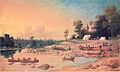
Encampment, Winnipeg River (1846), by Paul Kane

See also
 In Spanish: Río Winnipeg para niños
