
Grand Portage National Monument facts for kids
|
Grand Portage National Monument
|
|

The Great Hall at Grand Portage
|
|

Location in Minnesota

Location in the United States
|
|
| Location | Cook County, Minnesota |
|---|---|
| Nearest city | Grand Portage |
| Area | 710 acres (2.9 km2) |
| Visitation | 68,856 (2007) |
| Website | Grand Portage National Monument |
| NRHP reference No. | 66000111 |
Quick facts for kids Significant dates |
|
| Designated HD | October 15, 1966 |
| Designated NMON | January 27, 1960 |
Grand Portage National Monument is a special place in Minnesota. It's on the north shore of Lake Superior. This monument protects an important area where people used to trade furs a long time ago. It also celebrates the history of the Ojibwe people, who are also called Anishinaabeg. This spot was one of the four main fur trading centers for the British Empire in North America.
The "Grand Portage" is a long path, about 8.5 miles (13.7 km) long. It's a footpath that goes around big waterfalls and fast-moving water on the Pigeon River. This river flows into Lake Superior. This path was a key part of an old trade route. French-Canadian traders, called voyageurs and coureur des bois, used it to carry furs and supplies. They traveled between their winter homes and trading posts further east.
This route, with its rivers, lakes, and portages, was super important before modern transportation. It gave quick water access from Canada's settled areas to places rich in furs. About 50 miles (80 km) from Lake Superior, this trade route crosses the Height of Land Portage. This spot is on the Northern continental divide. It connects South Lake, which flows to the Great Lakes, with North Lake, which flows to the Rainy River. So, Grand Portage was a vital link between two huge river systems. One led to Hudson Bay and the other to the Atlantic Ocean.
Contents
History of Grand Portage

Native American groups likely used this area, called Gichi-onigaming (meaning "the Great Carrying Place"), as far back as 2,000 years ago. They traveled from their summer homes on Lake Superior to their winter hunting grounds. In 1729, a Cree guide named Auchagah drew a map for a French fur trader, Pierre Gaultier de Varennes, sieur de La Vérendrye. The map showed how to reach the "western sea" of Lake Winnipeg. Over time, Grand Portage became the main entry point to the northern lands rich in furs. It connected faraway trading posts to big markets around the world.
The Grand Portage trail is an 8.5-mile (13.7 km) path. It links Grand Portage with Fort Charlotte on the Pigeon River. Voyageurs from the Rupert's Land area would bring their furs by canoe to Fort Charlotte. Then, they would carry the bundles of fur along the portage trail to Grand Portage. There, they met traders from Montreal. They exchanged furs for goods and supplies. Each group of canoes then went back to where they started. The fur traders built Fort Charlotte as a trading fort at Grand Portage. They also built the Grand Hall in the French colonial style. This building was used for meetings, a general store, and other activities.

After the Jay Treaty was signed in 1795, British fur trading in Grand Portage faced challenges. The border between the U.S. and Canada was set in 1818. More U.S. settlers also started moving into the Minnesota Territory. In July 1802, leaders of the North West Company, a very successful fur trade company, met at their Grand Hall. They decided to move their summer base about 50 miles (80 km) north. They moved it to the mouth of the Kaministiquia River. This was to get away from U.S. territory.
The North West Company then took apart its 18 buildings. They moved the materials north by schooners to build a new Fort William. The buildings were made from squared spruce, pine, and birch wood. More than 2,000 cedar pickets surrounded them.
In 1854, the Ojibwe people signed a treaty with the U.S. government. This treaty made Grand Portage part of their reservation. A school was built for tribe members, and a post office opened in 1856. In 1887, the government decided to open the reservation to general settlement.
In 1951, the area became the Grand Portage National Historic Site. It opened for visitors. In 1958, it was named a National Monument. The portage trail is also a Minnesota State Historic Site. The monument's 710 acres (2.9 km2) are all within the Grand Portage Indian Reservation. The trading post was rebuilt to help people learn about the fur trade and Ojibwe ways of life. It was added to the National Register of Historic Places in 1966.
Things to See and Do
The portage trail looks much like it did long ago. Visitors can hike the 8.5 miles (13.7 km) from Lake Superior to the Pigeon River.
Volunteers and park staff dress in old-fashioned clothes. They work in the Kitchen, Great Hall, Canoe Warehouse, Ojibwe Village, and Voyageur Encampment. They explain what life was like at the trading post around the year 1800. Every second weekend in August, the monument hosts a rendezvous event. This is a re-enactment of old trading gatherings. At the same time, the Grand Portage Indian Reservation holds a pow wow. Many Native American visitors come for this event. The Rendezvous and Pow Wow happen during the Perseid meteor shower.
The four rooms off the Great Hall show different parts of the fur trade. One room is a shareholder's bedroom. Another is a trading post with examples of furs and goods. A third shows a London street with finished goods made from furs. The last room is a hatter's shop, showing how beaver pelts became fancy felt hats.
Grand Portage Heritage Center

The Grand Portage National Monument Heritage Center opened in 2007. It has exhibits about Ojibwe culture and the fur trade. There's also a bookstore, videos, park offices, and a classroom. This center is a team effort between the National Park Service and the Grand Portage Band of Lake Superior Chippewa. It looks out over the rebuilt fur trading post.
The Grand Portage Trail
The Grand Portage trail was created to avoid many small portages. It starts at the stockade on Grand Portage Bay of Lake Superior. The 8.5-mile (13.7 km) trail goes west into the wilderness. It reaches the Pigeon River, bypassing many rapids and waterfalls. Two famous waterfalls are Middle Falls and Pigeon Falls. You can see Middle Falls easily from Pigeon River Provincial Park in Canada.
The portage starts at Lake Superior, which is about 600 feet (183 m) above sea level. It climbs through two gaps in the Sawtooth Mountain range. It levels off around 1,000 feet (305 m) after about 2.6 miles (4.2 km). Another 1.5 miles (2.4 km) brings you to the inland county highway. From there, the trail is flatter, rising to 1,300 feet (396 m). This is the highest point on the trail. Then it drops back down to 1,260 feet (384 m) at Fort Charlotte on the Pigeon River. The highest point of the trail is now a large beaver pond. A boardwalk has been added over the beaver dam for visitors.
Images for kids
-
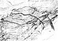
The Route of the Portage
-
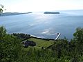
The Grand Portage depot and dock as seen from the top of Mount Rose
-
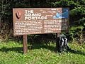
Informational sign located at the midway point of the Grand Portage Trail
-
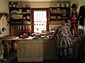
A visiting reenactor in the reconstructed trade shop located in the Great Hall
-
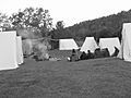
Rendezvous camp at Grand Portage August 2008
-
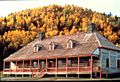
Great Hall in the fall of 1983. Mount Rose rises behind the hall.
-
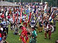
Lake Superior Band of Chippewa Pow Wow at the Grand Portage Indian Reservation in 2009


See also
- List of national monuments of the United States
- Coureur des bois
- Fur trade
- Fort William Historical Park
- Grand Portage, Minnesota – Unorganized Territory of Cook County
- Grand Portage Indian Reservation
- Grand Portage State Park, Minnesota
- Grand Portage (community), Minnesota – Unincorporated community located within both the reservation and unorganized territory
- Isle Royale National Park
- North West Company
- Pigeon River
- Voyageurs
