
Kaministiquia River facts for kids
Quick facts for kids Kaministiquia River |
|
|---|---|

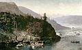
The Red River Expedition at Kakabeka Falls by Frances Anne Hopkins, 1877
|
|

Location of the mouth of the Kaministiquia River
|
|
| Native name | Gaa-Ministigweyaa |
| Country | Canada |
| Province | Ontario |
| Region | Northern Ontario |
| District | Thunder Bay |
| Physical characteristics | |
| Main source | Dog Lake Ontario 420 m (1,380 ft) 48°41′53″N 89°38′29″W / 48.69806°N 89.64139°W |
| River mouth | Lake Superior at the city of Thunder Bay, Ontario 183.5 m (602 ft) 48°23′34″N 89°12′58″W / 48.39278°N 89.21611°W |
| Length | 95 km (59 mi) |
| Basin features | |
| River system | Great Lakes Basin |
The Kaministiquia River is a river in Ontario, Canada. It flows into Lake Superior at the city of Thunder Bay. Its name, Kaministiquia, comes from the Ojibwe language. It means "where a stream flows in island." This is because there are two big islands, McKellar and Mission, at the river's mouth.
The river's mouth has three main branches. Early French maps called them "les trois rivières" (the three rivers). The southern branch is the Mission River, the middle one is the McKellar River, and the northern one is the Kaministiquia itself. Many local people simply call it the Kam River.
The amount of water flowing in the Kaministiquia River system is controlled by several dams. These include dams at Dog Lake, Greenwater, Kashabowie, and Shebandowan. Two power plants, one at Kakabeka Falls and another at Silver Falls, use the river's water to make electricity. These plants are run by Ontario Power Generation (OPG).
Contents
Geography
The Kaministiquia River is home to Kakabeka Falls, a very large waterfall. It is the biggest waterfall in the Lake Superior area, standing 47 metres (154 ft) tall. Below these falls, the river flows through a wide, flat area. This area was formed by an ancient river that flowed here after the last ice age.
Tributaries
A tributary is a smaller stream or river that flows into a larger one. Here are some rivers that flow into the Kaministiquia River:
- Whitefish River
- Matawin River
- Depot Creek
- Dog River
History of the Kaministiquia River
The Kaministiquia area was first mentioned in 1681. It was shown on a map in 1671 as a river leading to the Assinipoualacs. Like the Pigeon River, the Kaministiquia River was a very important water route into western Canada.
During the time when the French controlled the area, two fur trading posts were built at the river's delta. The first was built by Daniel Greysolon, sieur Dulhut, in the late 1600s. A second one was built in 1717 by Zacharie Robutel de la Noue. Both of these posts are now known as Fort Kaministiquia. Many different spellings were used for the name back then.
Later, in 1803, the British North West Company built a trading post called Fort William, Ontario at the river's mouth. The Hudson's Bay Company, a rival British company, also built a post upstream. In 1821, these two rival posts joined together. Over the years, the river's name has been spelled in many ways, but it is now officially Kaministiquia.
After a canal and locks opened at Sault Ste. Marie, Michigan in 1855, it became easier for boats to travel on the river. However, silt (fine sand and mud) built up at the river's main mouth. This created a sand bar, so the river had to be dredged (cleaned out) starting in 1873. This allowed bigger boats to go further upstream.
After 1883, the lower part of the Kaministiquia River became very industrial. The Canadian Pacific Railway (CPR) built many things there. These included railway yards, coal yards, docks, grain elevators, and sawmills. The double-deck Jackknife Bascule Bridge was built by the CPR in 1913. This bridge allowed trains and vehicles to cross from the mainland to Mission Island. The Thunder Bay Generating Station is also located on Mission Island in the river's delta. In the early 1900s, the three branches of the river at the delta were made much deeper and wider. This made it easier for ships to navigate.
Many famous Canadian artists have painted the Kaministiquia River. These include William Armstrong, Frances Anne Hopkins (who painted The Red River Expedition at Kakabeka Falls in 1877), and Lucius Richard O'Brien (who painted Kakabeka Falls in 1882).
The Voyageur Route

The Kaministiquia River was an important route for voyageurs and fur traders. These were people who traveled by canoe to trade furs in early Canada. For a while, the Grand Portage route was more popular. However, that route was on the US side of the border.
In 1784, the North West Company wanted to find a route on the British side. Roderick McKenzie found the Kaministiquia route in 1798. This new route was approved in 1799.
The Kaministiquia and Grand Portage were the two main routes used by Canadian fur traders to travel from the Great Lakes to western Canada. The Kaministiquia route was first used in 1688 by Jacques de Noyon. Around 1731, La Vérendrye used Grand Portage, which then became the preferred way to travel.
It was hard for western traders to go all the way to Montreal and back in one season. So, they would meet at Grand Portage to exchange goods with boats coming from Montreal. By 1803, it was clear that Grand Portage was on the US side of the border. Because of this, the main trading post was moved about 40 miles (64 km) northeast to Fort William.
The canoe route started west from Fort William. There was only one short break (called a decharge) before reaching Kakabeka Falls. Traders had to carry their canoes and goods around the falls using the Mountain Portage. The North West Company soon built a road to a supply depot above the falls.
From there, the route went north up a fast-flowing section with at least seven portages. Then, after more portages and climbing higher, they reached Dog Lake (Ontario). This was about 25 miles (40 km) northwest of Fort William. Next, it was an easier 50 miles (80 km) journey northwest up the winding Dog River (Ontario), Jordain Creek, and Cold Water Creek to Cold Water Lake.
After that, a difficult, wet section began. This included the 3-mile Prairie Portage, Height of Land Lake, the half-mile De Milieu Portage, Lac de Milieu, and the mile-and-a-half Savanne Portage. This led to the Savanne River, which flows into the Lake Winnipeg area. Finally, they went west down the Savanne to Lac des Mille Lacs.
Since the Seine River (Ontario) was too rough for large canoes, the route went over the quarter-mile Baril Portage. This led to the Pickerel River and Pickerel Lake. Then, the Pickerel and Deux Rivières Portages led to Sturgeon Lake. From there, they went down the Maligne River to Lac La Croix. This is where the route from Grand Portage joined in from the southeast.
Images for kids
-
The Red River Expedition at Kakabeka Falls by Frances Anne Hopkins, 1877
See also
 In Spanish: Río Kaministiquia para niños
