
Sault Ste. Marie, Michigan facts for kids
Quick facts for kids
Sault Ste. Marie, Michigan
|
|||
|---|---|---|---|
| City of Sault Ste. Marie | |||

View of Sault Ste. Marie from the Canadian side of the St. Marys River
|
|||
|
|||
| Nickname(s):
The Sault, The Soo
|
|||

Location within Chippewa County
|
|||

Sault Ste. Marie, Michigan
Location in Michigan

Sault Ste. Marie, Michigan
Location in the United States
|
|||
| Country | United States | ||
| State | Michigan | ||
| County | Chippewa | ||
| Established | 1668 | ||
| Incorporated | 1879 (village) 1887 (city) |
||
| Government | |||
| • Type | Council–manager | ||
| Area | |||
| • Total | 20.02 sq mi (51.86 km2) | ||
| • Land | 14.76 sq mi (38.22 km2) | ||
| • Water | 5.27 sq mi (13.64 km2) 26.74% | ||
| Elevation | 617 ft (188 m) | ||
| Population
(2020)
|
|||
| • Total | 13,337 | ||
| • Density | 903.77/sq mi (348.95/km2) | ||
| Time zone | UTC-5 (EST) | ||
| • Summer (DST) | UTC-4 (EDT) | ||
| ZIP code(s) |
49783
|
||
| Area code(s) | 906 | ||
| FIPS code | 26-71740 | ||
| GNIS feature ID | 637276 | ||

Sault Ste. Marie (pronounced SOO saynt mə REE) is a city in the Upper Peninsula of Michigan, USA. It is the main city of Chippewa County. In 2020, about 13,337 people lived here. It is the second-largest city in the Upper Peninsula.
Sault Ste. Marie was first settled by French colonists in 1668. This makes it the oldest city in Michigan.
The city is located on the St. Marys River. This river connects Lake Superior to Lake Huron. It also forms part of the border between the United States and Canada. Right across the river is another city called Sault Ste. Marie, Ontario in Canada. The two cities are linked by a bridge.
Between the two cities are the Soo Locks. These locks help ships travel between Lake Superior and the other Great Lakes. Sault Ste. Marie is also home to Lake Superior State University.
Contents
What's in a Name?
The city's name comes from a French phrase, Les Saults de Sainte Marie. Sainte Marie means "Saint Mary," which was the name of the river. Saults meant "rapids" in old French. So, the name means "the Rapids of Saint Mary."
The Saint Mary's River flows from Lake Superior to Lake Huron. It runs between the two cities named Sault Ste. Marie. Even though the spelling is the same in English and French, the pronunciation is different. In English, we say SOO saynt mə REE. People on both sides of the border often call the city "The Sault" or "The Soo."
A Look Back in Time

For many years, the Anishinaabe people lived in this area. They called it Baawitigong, meaning "at the cascading rapids."
In 1668, French missionaries Claude Dablon and Jacques Marquette started a mission here. This made Sault Ste. Marie one of the oldest European settlements in Michigan. In 1671, French officials claimed this land for King Louis XIV of France.
In the 1700s, the city became a key place for the fur trade. A Scots-Irish trader named John Johnston settled here in 1790. He married Ozhaguscodaywayquay, an important Ojibwe woman. Their family was well-known among Native Americans and Europeans.
After the War of 1812, the border between the U.S. and Canada was set along the river. This divided the community. The U.S. built Fort Brady nearby, bringing new settlers.
The rapids in the river made it hard for ships to pass. At first, ships had to be moved around the rapids. Later, only the cargo was moved. In 1855, the first American lock, called the State Lock, was built. This made shipping much easier. The locks have been made bigger and better over time.
In 1938, a building called the Pullar Community Building was built. It opened in 1939 and had an indoor ice rink with artificial ice. This was a new idea back then! The city still owns this ice rink today.
City Layout
The city covers about 20.16 square miles (51.86 square kilometers). About 14.77 square miles (38.22 square kilometers) is land, and 5.39 square miles (13.64 square kilometers) is water. The downtown area is on an island. This island is formed by the Sault Ste. Marie Power Canal and the St. Mary's River.
Weather and Climate
Sault Ste. Marie has cold, snowy winters and warm summers. It gets a lot of snow, averaging about 120 inches (3 meters) each winter. In December 1995, a huge snowstorm dropped 62 inches (1.5 meters) of snow in just five days!
The temperature can be very cold in winter, sometimes dropping to -36°F (-38°C). In summer, it can get warm, up to 98°F (37°C). The average temperature in January is about 13°F (-11°C), and in July, it's around 64°F (18°C).
The city gets the most rain in September and October. This is because the Great Lakes affect the weather. In autumn, the lakes are warmer than the land. This causes more clouds and rain.
-
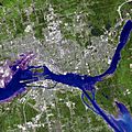
Satellite image from June 2007
-
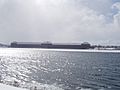
Sault Ste. Marie, Michigan Saint Marys Falls Hydropower Plant generation station
-
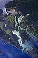
Astronaut photograph of Sault Ste. Marie


| Climate data for Sault Ste. Marie, Michigan (Sault Ste. Marie Municipal Airport) 1991–2020 normals, extremes 1888–present | |||||||||||||
|---|---|---|---|---|---|---|---|---|---|---|---|---|---|
| Month | Jan | Feb | Mar | Apr | May | Jun | Jul | Aug | Sep | Oct | Nov | Dec | Year |
| Record high °F (°C) | 48 (9) |
50 (10) |
83 (28) |
85 (29) |
91 (33) |
93 (34) |
98 (37) |
98 (37) |
95 (35) |
83 (28) |
74 (23) |
62 (17) |
98 (37) |
| Mean maximum °F (°C) | 39.3 (4.1) |
41.9 (5.5) |
52.5 (11.4) |
67.5 (19.7) |
81.8 (27.7) |
85.6 (29.8) |
87.7 (30.9) |
86.6 (30.3) |
81.6 (27.6) |
71.8 (22.1) |
56.4 (13.6) |
44.5 (6.9) |
89.4 (31.9) |
| Mean daily maximum °F (°C) | 24.0 (−4.4) |
26.4 (−3.1) |
35.5 (1.9) |
48.5 (9.2) |
63.2 (17.3) |
72.5 (22.5) |
76.8 (24.9) |
75.8 (24.3) |
68.0 (20.0) |
54.1 (12.3) |
41.2 (5.1) |
30.5 (−0.8) |
51.4 (10.8) |
| Daily mean °F (°C) | 16.2 (−8.8) |
17.8 (−7.9) |
26.7 (−2.9) |
39.4 (4.1) |
52.1 (11.2) |
61.1 (16.2) |
66.0 (18.9) |
65.6 (18.7) |
58.4 (14.7) |
46.3 (7.9) |
34.8 (1.6) |
23.8 (−4.6) |
42.4 (5.8) |
| Mean daily minimum °F (°C) | 8.4 (−13.1) |
9.3 (−12.6) |
17.9 (−7.8) |
30.2 (−1.0) |
41.0 (5.0) |
49.7 (9.8) |
55.2 (12.9) |
55.4 (13.0) |
48.7 (9.3) |
38.5 (3.6) |
28.3 (−2.1) |
17.1 (−8.3) |
33.3 (0.7) |
| Mean minimum °F (°C) | −14.0 (−25.6) |
−11.1 (−23.9) |
−4.4 (−20.2) |
15.9 (−8.9) |
29.8 (−1.2) |
37.4 (3.0) |
45.0 (7.2) |
45.0 (7.2) |
35.5 (1.9) |
26.7 (−2.9) |
10.4 (−12.0) |
−5.1 (−20.6) |
−17.6 (−27.6) |
| Record low °F (°C) | −36 (−38) |
−37 (−38) |
−28 (−33) |
−13 (−25) |
18 (−8) |
26 (−3) |
36 (2) |
29 (−2) |
25 (−4) |
15 (−9) |
−12 (−24) |
−31 (−35) |
−37 (−38) |
| Average precipitation inches (mm) | 2.21 (56) |
1.51 (38) |
1.81 (46) |
2.63 (67) |
2.64 (67) |
2.85 (72) |
3.07 (78) |
3.19 (81) |
3.93 (100) |
4.38 (111) |
3.44 (87) |
2.80 (71) |
34.46 (875) |
| Average snowfall inches (cm) | 30.3 (77) |
20.7 (53) |
13.0 (33) |
7.6 (19) |
0.4 (1.0) |
0.0 (0.0) |
0.0 (0.0) |
0.0 (0.0) |
0.0 (0.0) |
1.7 (4.3) |
16.0 (41) |
30.4 (77) |
120.1 (305) |
| Average precipitation days (≥ 0.01 in) | 18.5 | 13.5 | 12.3 | 11.7 | 11.2 | 11.1 | 11.3 | 10.6 | 13.1 | 16.5 | 16.5 | 18.6 | 164.9 |
| Average snowy days (≥ 0.1 in) | 19.6 | 15.5 | 10.4 | 5.5 | 0.5 | 0.0 | 0.0 | 0.0 | 0.1 | 2.0 | 10.3 | 17.4 | 81.3 |
| Average relative humidity (%) | 77.2 | 75.2 | 74.7 | 69.9 | 67.9 | 74.7 | 76.3 | 79.6 | 81.6 | 80.4 | 81.7 | 81.0 | 76.7 |
| Average dew point °F (°C) | 7.5 (−13.6) |
8.2 (−13.2) |
17.2 (−8.2) |
28.2 (−2.1) |
38.7 (3.7) |
49.3 (9.6) |
55.6 (13.1) |
55.6 (13.1) |
48.6 (9.2) |
38.3 (3.5) |
27.3 (−2.6) |
14.7 (−9.6) |
32.4 (0.2) |
| Mean monthly sunshine hours | 104.9 | 142.5 | 206.4 | 227.5 | 280.3 | 281.2 | 303.6 | 248.9 | 172.9 | 122.6 | 70.4 | 77.4 | 2,238.6 |
| Percent possible sunshine | 37 | 49 | 56 | 56 | 60 | 59 | 64 | 57 | 46 | 36 | 25 | 29 | 50 |
| Source: NOAA (relative humidity, dew point, and sun 1961–1990) | |||||||||||||
Who Lives Here?
| Historical population | |||
|---|---|---|---|
| Census | Pop. | %± | |
| 1860 | 596 | — | |
| 1880 | 1,947 | — | |
| 1890 | 5,760 | 195.8% | |
| 1900 | 10,538 | 83.0% | |
| 1910 | 12,615 | 19.7% | |
| 1920 | 12,096 | −4.1% | |
| 1930 | 13,755 | 13.7% | |
| 1940 | 15,847 | 15.2% | |
| 1950 | 17,912 | 13.0% | |
| 1960 | 18,722 | 4.5% | |
| 1970 | 15,136 | −19.2% | |
| 1980 | 14,448 | −4.5% | |
| 1990 | 14,689 | 1.7% | |
| 2000 | 14,324 | −2.5% | |
| 2010 | 14,144 | −1.3% | |
| 2020 | 13,337 | −5.7% | |
| source: | |||
In 2020, Sault Ste. Marie had a population of 13,337 people. The city is home to people from many different backgrounds.
What Drives the Economy?
Tourism is a very important business in Sault Ste. Marie. Many visitors come to see the Soo Locks. The nearby Kewadin Casino, Hotel and Convention Center, owned by the Sault Tribe of Chippewa Indians, also attracts many people.
The beautiful forests, lakes, and the Lake Superior shoreline are also big draws. Sault Ste. Marie is a great starting point to explore Lake Superior's northern shore. The Sault Ste. Marie International Bridge connects the city to its Canadian twin city.
Learning and Schools

Lake Superior State University
Sault Ste. Marie is home to Lake Superior State University (LSSU). It started in 1946. The campus used to be Fort Brady, an old army fort. LSSU is Michigan's smallest public university, with about 1,500 students.
Schools for Kids
The main public high school is Sault Area High School (SAHS). It has a career center attached, which is special. Their mascot is the Blue Devil. The school offers 24 different sports teams for boys and girls. Malcolm High School is another option for students.
Sault Ste. Marie has two middle schools: Sault Area Middle School and Joseph K. Lumsden Bahweting School. The Bahweting School is connected to Native American culture.
There are also two elementary schools: Lincoln Elementary and Washington Elementary. St. Mary's Catholic School serves students from kindergarten to 8th grade.
Sports and Fun
Sault Ste. Marie has exciting sports to watch! The Lake Superior State University Lakers play hockey and other sports. Their hockey team is very famous. They have won three national championships! The Lakers play their home games at Taffy Abel Arena.
The city also hosts the International 500 Snowmobile Race every year. This race is like the Indianapolis 500, but for snowmobiles! It brings in people from all over the U.S. and Canada.
Getting Around

Sault Ste. Marie is the northern end of Interstate 75. This highway goes all the way south to Florida. The International Bridge connects the city to Canada.
For air travel, people use the Chippewa County International Airport. Smaller planes use the Sault Ste. Marie Municipal Airport.
The city was once the namesake of the Soo Line Railroad. Today, Canadian National Railway operates the train lines here.
The Sugar Island Ferry takes cars and people between Sault Ste. Marie and Sugar Island. The United States Postal Service even has a "Marine Post Office" right in the locks! It delivers mail to ships as they pass through.
The Soo Locks are a very important part of transportation. They let large ships travel between Lake Superior and the lower Great Lakes. The water drops 21 feet (7 meters) at the rapids, so the locks help ships go up and down. About 10,000 ships use the locks each year! They are closed in winter when the lakes freeze.
Famous People from Sault Ste. Marie
- Taffy Abel: A former Olympic and NHL hockey player.
- Jeff Blashill: A coach for the NHL's Tampa Bay Lightning.
- John Johnston: An important fur trader in the early days.
- Jane Johnston Schoolcraft: The first Native American literary writer and poet.
- Terry O'Quinn: An actor known for the TV show Lost.
- Chase S. Osborn: Michigan's only Governor from the Upper Peninsula.
Cool Places to Visit
- Pullar Stadium: This ice arena opened in 1939. It is where the Soo Eagles hockey team plays.
- The Ramada Plaza Hotel Ojiway: This elegant hotel opened in 1927. Many famous guests have stayed here, including presidents.
- The Soo Theatre: This theater has been around for over 80 years. It hosts plays, movies, and musicals.
- Holy Name of Mary Pro-Cathedral (Sault Ste. Marie, Michigan): This church was started by Jesuits in 1668. It is one of the oldest parishes in the United States.
- Soo Locks: These famous locks help ships travel between Lake Superior and the lower Great Lakes. They are a must-see!
- Taffy Abel Arena: This is the home of Lake Superior State University's Division 1 hockey team. It is named after hockey player Taffy Abel.
- Lake Superior State University: The university campus used to be Fort Brady. Many of its historic buildings are still used today.
Sister City
Sault Ste. Marie has one sister city:
 Sault Ste. Marie, Ontario, Canada (This is also its twin city across the river!)
See also
 In Spanish: Sault Ste. Marie (Míchigan) para niños
