
Chippewa County, Michigan facts for kids
Quick facts for kids
Chippewa County
|
||
|---|---|---|

Chippewa County Courthouse, Sault Ste. Marie
|
||
|
||

Location within the U.S. state of Michigan
|
||
 Michigan's location within the U.S. |
||
| Country | ||
| State | ||
| Founded | December 22, 1826 | |
| Named for | Ojibwe people | |
| Seat | Sault Ste. Marie | |
| Largest city | Sault Ste. Marie | |
| Area | ||
| • Total | 2,698 sq mi (6,990 km2) | |
| • Land | 1,558 sq mi (4,040 km2) | |
| • Water | 1,140 sq mi (3,000 km2) 42%% | |
| Population
(2020)
|
||
| • Total | 36,785 | |
| • Density | 25/sq mi (10/km2) | |
| Time zone | UTC−5 (Eastern) | |
| • Summer (DST) | UTC−4 (EDT) | |
| Congressional district | 1st | |

Chippewa County (say it: CHIH-puh-wah) is a county located in the eastern part of the Upper Peninsula in Michigan, a state in the United States. In 2020, about 36,785 people lived here. The main town and government center is Sault Ste. Marie.
The county got its name from the Ojibwe people, also known as the Chippewa. It was officially created and started its government in 1826. Chippewa County is part of the Sault Ste. Marie area, which is a "micropolitan" area. This means it's a smaller city area with close ties to nearby towns.
Chippewa County has coastlines on both Lake Huron and Lake Superior. This makes it one of only two counties in the U.S. that touch two of the Great Lakes. The other is its neighbor, Mackinac County. The county's shape follows the border with Canada, which runs along the St. Marys River. Drummond Island is also a part of Chippewa County.
Contents
Exploring Chippewa County's Geography
According to the U.S. Census Bureau, Chippewa County covers a total area of 2,698 square miles. About 1,558 square miles of this is land, and 1,140 square miles (42%) is water. This makes it the second-largest county in Michigan by land area. It is also the fifth-largest by total area.
A special line called the Michigan Meridian runs through the eastern part of the county. This line helps surveyors measure land. For example, part of M-129 (Meridian Road) follows this line. In Sault Ste. Marie, Meridian Street also follows it.
Neighboring Areas: Land and Water
Chippewa County shares borders with other counties and districts.
Counties by Land
- Mackinac County (to the south)
- Luce County (to the west)
Areas by Water
- Presque Isle County (to the south)
- Algoma District, Ontario, Canada (to the north)
- Manitoulin District, Ontario, Canada (to the east)
Protected Natural Areas
Chippewa County is home to several important natural areas. These places help protect wildlife and nature.
- Harbor Island National Wildlife Refuge
- Part of the Hiawatha National Forest
- The Whitefish Point Unit of the Seney National Wildlife Refuge
Fun in Game Areas
The Munuscong Bay is a great spot for outdoor activities. You can go hunting, boating, and watch birds there. It's especially known for duck hunting, with many types of ducks like mallards and green-winged teal. The Bay is also very popular for ice fishing in winter. During the start of duck season in late September, many hunters visit the Bay. This area is a key stop for many waterfowl during their yearly migrations.
Communities in Chippewa County

Chippewa County has different types of communities.
The Main City
- Sault Ste. Marie is the largest city and the county seat.
Small Villages
Special Townships
- Kinross Charter Township is a "charter township," which means it has more local powers than a regular township.
Local Townships
- Bay Mills Township
- Bruce Township
- Chippewa Township
- Dafter Township
- Detour Township
- Drummond Township
- Hulbert Township
- Pickford Township
- Raber Township
- Rudyard Township
- Soo Township
- Sugar Island Township
- Superior Township
- Trout Lake Township
- Whitefish Township
Special Census Places
These are areas that are not officially cities or villages but are recognized for census purposes.
Other Small Communities
- Barbeau
- Bay Mills
- Cartonville (a ghost town)
- Dafter
- Drummond
- Eckerman
- Emerson
- Goetzville
- Homestead
- Johnswood
- Hulbert
- Kelden
- Kinross
- Mission
- Neebish Island
- Paradise
- Pickford
- Raber
- Raco
- Rudyard
- Shelldrake (a ghost town)
- Stalwart
- Stirlingville
- Strongs
- Trout Lake
- Whitefish Point
- Vermilion
Native American Reservations
- The Bay Mills Indian Community has land in Bay Mills Township and Superior Township. They also have a smaller area in Sugar Island Township.
- The Sault Tribe of Chippewa Indians has land in different spots. These include Kinross Charter Township, Sugar Island Township, and parts of Sault Ste. Marie city.
Population and People
| Historical population | |||
|---|---|---|---|
| Census | Pop. | %± | |
| 1830 | 626 | — | |
| 1840 | 534 | −14.7% | |
| 1850 | 898 | 68.2% | |
| 1860 | 1,603 | 78.5% | |
| 1870 | 1,689 | 5.4% | |
| 1880 | 5,248 | 210.7% | |
| 1890 | 12,019 | 129.0% | |
| 1900 | 21,338 | 77.5% | |
| 1910 | 24,472 | 14.7% | |
| 1920 | 24,818 | 1.4% | |
| 1930 | 25,047 | 0.9% | |
| 1940 | 27,807 | 11.0% | |
| 1950 | 29,206 | 5.0% | |
| 1960 | 32,655 | 11.8% | |
| 1970 | 32,412 | −0.7% | |
| 1980 | 29,029 | −10.4% | |
| 1990 | 34,604 | 19.2% | |
| 2000 | 38,543 | 11.4% | |
| 2010 | 38,520 | −0.1% | |
| 2020 | 36,785 | −4.5% | |
| 2023 (est.) | 36,264 | −5.9% | |
| US Decennial Census 1790–1960 1900–1990 1990–2000 2010–2018 |
|||
In 2020, Chippewa County had a population of 36,785 people.
Getting Around: Transportation
Chippewa County has several important roads and airports.
Main Highways
All major highways in Michigan are maintained by the state.
 I-75 is Michigan's longest state highway. It ends at the Sault Ste. Marie International Bridge at the Canadian border.
 BS I-75 goes from I-75 into downtown Sault Ste. Marie. It ends at the ferry to Sugar Island.
 M-28 is Michigan's longest state highway. It ends near Sault Ste. Marie.
 M-48 travels through Pickford and Rudyard. It ends at I-75.
 M-80 starts at I-75 and goes through Kincheloe.
 M-123 connects Tahquamenon Falls to M-28.
- M-129 (also called Meridian Road) runs through the eastern part of the county.
- M-134 goes to Drummond Island.
 M-221 is the shortest highway in the county. It goes through Brimley.
County Roads
The Chippewa County Road Commission maintains other highways. These are given numbers by the state.
 H-40
H-40 H-63 follows the old route of US 2.
 FFH 42 (Whitefish Bay National Forest Scenic Byway) is a special scenic road. It is maintained by the US Forest Service and the County Road Commission.
Airports
- Chippewa County International Airport (CIU) serves the county. It offers flights connecting to larger airports.
- Drummond Island Airport (DRM) is a smaller airport with two runways.
The Michigan Aerospace Manufacturers Association has announced exciting plans for Chippewa County. It will be the home of a new command and control center for aerospace activities. This is part of Michigan's growing role in the aerospace and defense industry.
Images for kids
-
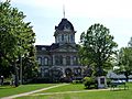
The Chippewa County Courthouse in Sault Ste. Marie.
See also
 In Spanish: Condado de Chippewa (Míchigan) para niños
