Drummond Township, Michigan facts for kids
Quick facts for kids
Drummond Township, Michigan
Drummond Island
|
|
|---|---|
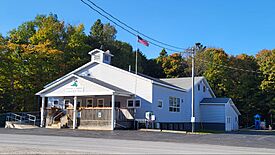
Frank J. Sasso Township Hall
|
|
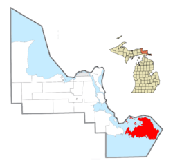
Location within Chippewa County
|
|
| Country | United States |
| State | Michigan |
| County | Chippewa |
| Established | 1888 |
| Area | |
| • Total | 248.99 sq mi (644.88 km2) |
| • Land | 128.91 sq mi (333.88 km2) |
| • Water | 120.09 sq mi (52.03 km2) |
| Elevation | 741 ft (247 m) |
| Population
(2020)
|
|
| • Total | 973 |
| • Density | 7.55/sq mi (2.92/km2) |
| Time zone | UTC-5 (Eastern (EST)) |
| • Summer (DST) | UTC-4 (EDT) |
| ZIP code(s) |
49726 (Drummond Island)
|
| Area code(s) | 906 |
| FIPS code | 26-23080 |
| GNIS feature ID | 1626193 |
Drummond Township is a special area in Chippewa County, Michigan. It's mostly made up of a very large island called Drummond Island. In 2020, about 973 people lived here.
Drummond Island is the seventh-largest island in the world that's located in a lake! It covers about 134 square miles (347 square kilometers). It's also the third-largest island in Lake Huron. Only Manitoulin Island and St. Joseph Island are bigger.
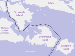
The island is connected to the mainland by the Drummond Island Ferry. This ferry travels between the island and DeTour Village. On the east side of Drummond Island, the border between Canada and the United States passes through a channel.
Contents
Exploring Drummond Island
Drummond Island is a unique place with a rich history and beautiful nature. It's a great spot for exploring and learning about how land borders were decided.
Island Communities
Drummond Island has several small communities. Each has its own story:
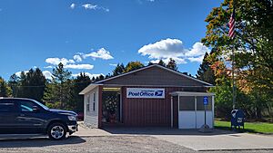
- Drummond (also called Drummond Island) is a community on the northwest side of the island. It's located on Potagannissing Bay. This area was named after a British commander, Gordon Drummond. He built a fort here after the War of 1812. The fort was left in 1822 when the island became part of the United States. A post office opened here in 1881. Today, the Drummond Island ZIP Code (49726) covers the whole township.
- Johnswood is a community on the southern coast of the island. It started around 1905 when a company took over the sawmills there. It was first called Scammon's Cove. A post office opened in 1905 and was later renamed Johns Wood in 1914. It closed in 1927.
- Lincoln is a small community located near the center of Drummond Island.
- Maxton is another community on the island. It was started in 1904 by a company that built a sawmill. Other sawmills also operated here for about 30 years. Maxton had a post office from 1904 until 1950.
A Look Back in Time
The township and island are named after Gordon Drummond. He was a Canadian-born officer who led the military and government of British Canada. He was important during the War of 1812. The local Ojibwe name for the island is Bootaagan-minising, which means "at the Mill Island."
The history of Drummond Island goes back many centuries. More recently, the island was occupied by the British during and after the War of 1812. It was the last British outpost on American land after the Treaty of Ghent in 1814. On November 14, 1828, the United States officially took control of the island.
How the Border Was Decided
After the War of 1812, the United States and Britain needed to figure out their exact border. They agreed to use the boundaries set by an earlier treaty from 1783. To do this, they sent teams of surveyors to map the area.
In 1820, surveyors like British explorer David Thompson began mapping islands in Lake Huron. This included St. Joseph Island, Drummond Island, and others. Mapping this area was hard because not much was known about the channels and shores.
After their surveys in 1820 and 1821, the officials decided how to divide the islands. They wanted to make sure no island was split in half and that each country got a fair share. In late 1821, they agreed that St. Joseph Island and Cockburn Island would go to Canada. Drummond Island, which is between them, would go to the United States.
Where is Drummond Island?
Drummond Township covers about 249 square miles (645 square kilometers). Almost half of this area is water! The island itself is mostly covered by forests. On the eastern side, you can see cliffs that are part of the Niagara Escarpment.
Most of Drummond Island, about two-thirds, is state land owned by Michigan. The island is home to a special environment called an alvar. This is a grassy limestone plain that is very rare and found in only a few places around the world. Drummond Island is the largest island in the Manitoulin Island chain that belongs to the United States.
Drummond Township is one of only seven places in Michigan that are made up entirely of islands. Other examples include Mackinac Island and Sugar Island Township.
Weather on Drummond Island
|
||||||||||||||||||||||||||||||||||||||||||||||||||||||||||||||||||||||||||||||||||||||||||||||||
Main Roads
- M-134 is the only main highway on Drummond Island. The Drummond Island Ferry connects M-134 on the island to the mainland at DeTour Village. This highway runs along the shore of Lake Huron and eventually connects to I-75 near St. Ignace. M-134 is one of only three state highways in Michigan that are located on islands.
Population Over Time
| Historical population | |||
|---|---|---|---|
| Census | Pop. | %± | |
| 1890 | 496 | — | |
| 1900 | 499 | 0.6% | |
| 1910 | 624 | 25.1% | |
| 1920 | 711 | 13.9% | |
| 1930 | 294 | −58.6% | |
| 1940 | 317 | 7.8% | |
| 1950 | 448 | 41.3% | |
| 1960 | 501 | 11.8% | |
| 1970 | 479 | −4.4% | |
| 1980 | 746 | 55.7% | |
| 1990 | 835 | 11.9% | |
| 2000 | 992 | 18.8% | |
| 2010 | 1,058 | 6.7% | |
| 2020 | 973 | −8.0% | |
In 2020, the population of Drummond Township was 973 people.
See also
 In Spanish: Municipio de Drummond para niños
 | Laphonza Butler |
 | Daisy Bates |
 | Elizabeth Piper Ensley |


