
St. Ignace, Michigan facts for kids
Quick facts for kids
St. Ignace, Michigan
|
|
|---|---|
| City of Saint Ignace | |

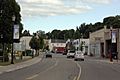
Downtown St. Ignace along BL I-75 in 2011
|
|
| Motto(s):
Gateway to Michigan's Upper Peninsula
|
|

Location within Mackinac County
|
|

St. Ignace, Michigan
Location in Michigan

St. Ignace, Michigan
Location in the United States
|
|
| Country | United States |
| State | Michigan |
| County | Mackinac |
| Settled | 1671 (St. Ignace Mission) |
| Incorporated | 1882 (village) 1883 (city) |
| Government | |
| • Type | Mayor–council |
| Area | |
| • Total | 2.65 sq mi (6.86 km2) |
| • Land | 2.64 sq mi (6.83 km2) |
| • Water | 0.01 sq mi (0.03 km2) |
| Elevation | 587 ft (179 m) |
| Population
(2020)
|
|
| • Total | 2,306 |
| • Density | 874.15/sq mi (337.56/km2) |
| Time zone | UTC-5 (Eastern (EST)) |
| • Summer (DST) | UTC-4 (EDT) |
| ZIP code(s) |
49781
|
| Area code(s) | 906 |
| FIPS code | 26-70840 |
| GNIS feature ID | 1627027 |
St. Ignace (say "IG-nəss") is a city in the state of Michigan, USA. It is the main city of Mackinac County. In 2020, about 2,306 people lived there. A separate area called St. Ignace Township is just north of the city.
St. Ignace is located on Lake Huron in Michigan's Upper Peninsula. It sits on the northern side of the Straits of Mackinac. The city is like a "gateway" to the Upper Peninsula for people coming from the Lower Peninsula. This is because it's at the north end of the Mackinac Bridge, which connects the two parts of Michigan. St. Ignace also has one of the two ports where you can catch a ferry to the nearby Mackinac Island.
The history of St. Ignace goes back to 1671. That's when French priests, called Jesuits, started the St. Ignace Mission. This makes St. Ignace one of the oldest European settlements in Michigan, after Sault Ste. Marie. Before the Europeans arrived, Native American tribes like the Wyandot people, Ojibwe, and Ottawa lived in the area. St. Ignace quickly became a main spot for fur trading with the French. It officially became a village in 1882 and a city in 1883. The Mackinac Bands of Chippewa and Ottawa Indians have their main office in St. Ignace. The city still has a large number of Native American residents today.
Contents
History of St. Ignace

St. Ignace is the second-oldest city in Michigan that was founded by Europeans. For thousands of years before the French arrived, different groups of Native Americans lived here. In the 1600s, the main people in this area were the Wyandot (also called Huron). They spoke the Wendat language.
By the early 1700s, the Anishinaabe Ojibwe people became more common in the area. They spoke an Algonquian language. Another related Anishinaabe group was the Ottawa (or Odawa). These tribes, along with the Potawatomi people, formed a group called the Council of Three Fires. Today, many descendants of these tribes live in northern Michigan.
French Exploration and Settlement
French explorer and priest Jacques Marquette started the St. Ignace Mission here in 1671. He was later buried here after he died. He named the mission after St. Ignatius of Loyola, who founded the Jesuit religious group. Jesuit priests worked as missionaries to teach Native Americans about Catholicism and French culture.
In 1673, Marquette left St. Ignace with explorer Louis Jolliet. They set out on May 17 with two canoes and five French-Indian helpers (Métis). Their goal was to find the Mississippi River, and they succeeded! They traveled down the river as far as Arkansas.

Another explorer, Sieur de La Salle, arrived in St. Ignace on August 27, 1679. He was exploring the Great Lakes on a ship called Le Griffon. In 1681, Louis de La Porte started Fort de Buade here. It was a place for fur trading. Later, Antoine Cadillac was in charge of the fort. The French closed the fort in 1697, and the Jesuits left their mission in 1705.
Changes in Control
The Ojibwe people became very important in Michigan in the 1700s. They were friends with the French during the Seven Years' War against the British. After the British won this war in 1763, they took over the land from France. This included the area of St. Ignace.
Later, after the American colonists won the American Revolutionary War in 1783, St. Ignace became part of the new United States. It was part of what was called the Northwest Territory.
St. Ignace was an important place for fur trading for both the French and the British. But by the early 1800s, its importance for fur trading went down. This happened because the United States stopped British Canadian traders from working across the border after the War of 1812. Also, people in Europe wanted fewer North American furs as their tastes changed.
Growth and Tourism
In 1882, a new railroad called the Detroit, Mackinac and Marquette Railroad was built. This connected St. Ignace to the big city of Detroit. This helped the village's economy a lot. Farmers and the lumber industry could now easily send their products to a large market. St. Ignace became an official village on February 23, 1882, and then a city in 1883.
In the late 1800s, a new part of its economy grew: tourism. St. Ignace started to attract visitors as a popular summer resort. It was also important because it connected people to Mackinac Island.
Since the late 1900s, St. Ignace has been a popular place for heritage tourism in the summer. People come to enjoy water sports and other activities.
The Mackinac Bands of Chippewa and Ottawa Indians is a tribe recognized by the state of Michigan. They are based in St. Ignace and also have groups in other nearby counties. This tribe has about 4,000 members and has been trying to get federal recognition since 1998. The larger, federally recognized Sault Ste. Marie Tribe of Chippewa Indians has a gaming casino in St. Ignace. They also have casinos in four other cities in Michigan.
Geography of St. Ignace
The city of St. Ignace covers about 2.65 square miles (6.86 square kilometers). Most of this is land, with only a small amount of water. Point St. Ignace is a piece of land that separates the Straits of Mackinac from Lake Huron. This point makes up the southern part of the city. The city is built along the western shore of Lake Huron, and its southern edge faces the Straits. Straits State Park is located in the southern part of the city.
Population and People

In 2010, there were 2,452 people living in St. Ignace. There were 1,064 households, and 633 families. The city had about 915 people per square mile (353 people per square kilometer).
Most of the people in St. Ignace were White (63.4%). A large number were Native American (27.8%). A small number were African American (1.0%) or Asian (0.3%). About 7.3% of people were from two or more races. About 1.1% of the population were Hispanic or Latino.
About 27% of households had children under 18 living with them. About 43% were married couples. The average age of people in the city was 44.5 years old. About 21.3% of residents were under 18.
Education
The local school district in St. Ignace is called St. Ignace Area Schools.
Things to See and Do
- The Kewadin Casino of St. Ignace is a popular place for tourists and provides many jobs.
- Straits State Park is at the south end of the city.
- The Wawatam Lighthouse is in the city's harbor.
- The harbor is also home to Coast Guard ice breaker ships, like the tug Katmai Bay and the large breaker Mackinaw.
Natural Landmarks
- St. Anthony's Rock is a natural limestone rock formation, or stack, that you can visit for free in the middle of town.
- Castle Rock is a similar, taller rock stack about 3 miles (5 km) north. You have to pay to visit it. It overlooks Lake Huron.
- Rabbit's Back is another large hill that overlooks Lake Huron, about 4 miles (6 km) north.
- Chain Lake, about 1 mile (2 km) inland, is a good spot for fishing.
Transportation

Main Roads
 I-75 goes over the Mackinac Bridge and through St. Ignace. If you go south on I-75, you'll go to the Lower Peninsula. If you go north, the freeway heads towards Sault Ste. Marie and Canada.
 BL I-75 follows the path of the old US 2 highway.
 US 2 ends in St. Ignace at I-75. If you go west on US 2, you'll travel along a beautiful part of Lake Michigan towards Manistique and Escanaba.
 H-63 (Mackinac Trail) is a road that goes north and south. It follows the old path of US 2 from just north of St. Ignace to Sault Ste. Marie.
Ferry Services
Two ferry companies, Shepler's Ferry and Mackinac Island Ferry Company, operate from St. Ignace. They take tourists and people who work there to Mackinac Island.
Airports
The closest airports with regular passenger flights are:
- Chippewa County International Airport in Kinross (northeast of St. Ignace, near I-75).
- Pellston Regional Airport in the Lower Peninsula.
Bus Service
Indian Trails offers daily bus service. You can take a bus from St. Ignace to East Lansing, Michigan, to Bay City, Michigan, and to Ironwood, Michigan.
Famous People from St. Ignace
- Prentiss M. Brown, a U.S. senator from Michigan.
- Tony Earl, a former governor of Wisconsin.
- Aubrey Fitch, a vice admiral in the United States Navy.
- Nicholas Orontony, an 18th-century Wyandot leader.
- Joe Ostman, a professional football player.
- Les Sweetland, a professional baseball pitcher.
Images for kids
-
Looking south in downtown St. Ignace
-

Post office
-
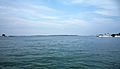
The ferry harbor with Mackinac Island in the distance


See also
 In Spanish: Saint Ignace (Míchigan) para niños
