
Manistique, Michigan facts for kids
Quick facts for kids
Manistique, Michigan
|
|
|---|---|
| City of Manistique | |
_2017.jpg)
Looking south along Cedar Street
|
|

Location within Schoolcraft County
|
|

Manistique, Michigan
Location in Michigan

Manistique, Michigan
Location in the United States
|
|
| Country | United States |
| State | Michigan |
| County | Schoolcraft |
| Incorporated | 1883 (village) 1901 (city) |
| Government | |
| • Type | Council–manager |
| Area | |
| • Total | 3.52 sq mi (9.11 km2) |
| • Land | 3.21 sq mi (8.31 km2) |
| • Water | 0.31 sq mi (0.80 km2) |
| Elevation | 600 ft (183 m) |
| Population
(2020)
|
|
| • Total | 2,828 |
| • Density | 881.27/sq mi (340.24/km2) |
| Time zone | UTC-5 (Eastern (EST)) |
| • Summer (DST) | UTC-4 (EDT) |
| ZIP code(s) |
49854
|
| Area code(s) | 906 |
| FIPS code | 26-50760 |
| GNIS feature ID | 1620685 |
Manistique (pronounced man-iss-TEEK) is a city in the U.S. state of Michigan. It is the only city in Schoolcraft County and also its county seat. A county seat is like the main town where the county government offices are located.
Manistique is located on the northern shore of Lake Michigan. It sits right where the Manistique River flows into the lake. This spot creates a natural harbor, which has been made even better with special walls called breakwaters and a lighthouse. The city gets its name from the river. Many people visit Manistique because of Lake Michigan and nearby places like Indian Lake State Park and Palms Book State Park.
Contents
Discover Manistique's Nickname
Manistique is often called "The Emerald City." This nickname comes from the beautiful, emerald-green waters of Kitch-iti-kipi. This is the largest natural spring in Michigan. The sports teams at Manistique Area Schools are even called the "Emeralds." You'll also find many local businesses using "Emerald City" in their names.
A Look at Manistique's History
.jpg)
.jpg)
Manistique was first known as Eastport. It took over from another town called Onota as the county seat. The name "Eastport" was used for the post office, but the community itself was always called Manistique.
The area officially became a village in 1883. Later, in 1901, it became a city. The river's name was originally spelled "Monistique." However, a mistake in the city's official document led to the spelling we use today: Manistique.
Manistique's Geography and Climate
Where is Manistique Located?
Manistique covers a total area of about 3.51 square miles (9.11 square kilometers). Most of this area, about 3.19 square miles (8.31 square kilometers), is land. The rest, about 0.32 square miles (0.80 square kilometers), is water.
What is Manistique's Climate Like?
Manistique has a climate with big changes in temperature throughout the year. Summers are usually warm or hot, and sometimes humid. Winters are cold, and can even be very cold. This type of weather is known as a humid continental climate.
| Climate data for Manistique WWTP, Michigan (1991–2020 normals, extremes 1896–present) | |||||||||||||
|---|---|---|---|---|---|---|---|---|---|---|---|---|---|
| Month | Jan | Feb | Mar | Apr | May | Jun | Jul | Aug | Sep | Oct | Nov | Dec | Year |
| Record high °F (°C) | 47 (8) |
61 (16) |
72 (22) |
80 (27) |
87 (31) |
96 (36) |
97 (36) |
101 (38) |
92 (33) |
84 (29) |
68 (20) |
58 (14) |
101 (38) |
| Mean daily maximum °F (°C) | 25.1 (−3.8) |
27.3 (−2.6) |
35.0 (1.7) |
45.4 (7.4) |
57.1 (13.9) |
67.2 (19.6) |
73.0 (22.8) |
73.5 (23.1) |
66.0 (18.9) |
53.3 (11.8) |
40.9 (4.9) |
31.0 (−0.6) |
49.6 (9.8) |
| Daily mean °F (°C) | 17.8 (−7.9) |
19.0 (−7.2) |
26.9 (−2.8) |
37.7 (3.2) |
49.0 (9.4) |
59.1 (15.1) |
64.8 (18.2) |
64.8 (18.2) |
57.8 (14.3) |
45.9 (7.7) |
34.5 (1.4) |
24.6 (−4.1) |
41.8 (5.4) |
| Mean daily minimum °F (°C) | 10.4 (−12.0) |
10.7 (−11.8) |
18.7 (−7.4) |
29.9 (−1.2) |
40.9 (4.9) |
51.0 (10.6) |
56.6 (13.7) |
56.2 (13.4) |
49.5 (9.7) |
38.6 (3.7) |
28.2 (−2.1) |
18.1 (−7.7) |
34.1 (1.2) |
| Record low °F (°C) | −25 (−32) |
−33 (−36) |
−31 (−35) |
−7 (−22) |
19 (−7) |
27 (−3) |
32 (0) |
31 (−1) |
19 (−7) |
17 (−8) |
−6 (−21) |
−25 (−32) |
−33 (−36) |
| Average precipitation inches (mm) | 1.70 (43) |
1.37 (35) |
1.85 (47) |
2.84 (72) |
2.98 (76) |
3.22 (82) |
3.43 (87) |
3.10 (79) |
3.75 (95) |
3.98 (101) |
2.62 (67) |
2.42 (61) |
33.26 (845) |
| Source: NOAA | |||||||||||||
Manistique's Population Over Time
| Historical population | |||
|---|---|---|---|
| Census | Pop. | %± | |
| 1880 | 693 | — | |
| 1890 | 2,940 | 324.2% | |
| 1900 | 4,126 | 40.3% | |
| 1910 | 4,722 | 14.4% | |
| 1920 | 6,380 | 35.1% | |
| 1930 | 5,198 | −18.5% | |
| 1940 | 5,399 | 3.9% | |
| 1950 | 5,086 | −5.8% | |
| 1960 | 4,875 | −4.1% | |
| 1970 | 4,324 | −11.3% | |
| 1980 | 3,962 | −8.4% | |
| 1990 | 3,456 | −12.8% | |
| 2000 | 3,583 | 3.7% | |
| 2010 | 3,097 | −13.6% | |
| 2020 | 2,828 | −8.7% | |
| Source: Census Bureau. Census 1880, 1970, 1980, 1990, 2000, 2010. |
|||
In 2020, about 2,828 people lived in Manistique. There were 1,193 households, which are groups of people living together. The city had about 340 people per square kilometer.
Most of the people in Manistique (81.9%) were White. About 9.7% were Native American, and 1.5% were Asian. Some people were from two or more racial backgrounds (3.9%). About 1.0% of the population was Hispanic or Latino.
About 27.9% of households had children under 18 living there. Many households (40.3%) were made up of just one person. About 20.3% of households had someone aged 65 or older living alone. The average age in Manistique was 43 years old.
Getting Around Manistique
Transportation Options
- You can reach Manistique using major roads like
 US 2 and
  M-94.
M-94. - Indian Trails offers daily bus service. You can travel between St. Ignace and Ironwood, Michigan.
- Manistique also has its own airport, the Schoolcraft County Airport (KISQ).
Gallery
-
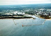
An aerial view of Manistique showing the Manistique River -
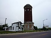
The Historic Manistique Water Tower and Schoolcraft County Museum -
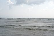
Lake Michigan looking south from the Manistique Boardwalk


See also
 In Spanish: Manistique (Míchigan) para niños
