
Schoolcraft County, Michigan facts for kids
Quick facts for kids
Schoolcraft County
|
|
|---|---|
.jpg)
Schoolcraft County Courthouse
|
|

Location within the U.S. state of Michigan
|
|
 Michigan's location within the U.S. |
|
| Country | |
| State | |
| Founded | March 9, 1843 (created) 1876 (organized) |
| Named for | Henry Schoolcraft |
| Seat | Manistique |
| Largest city | Manistique |
| Area | |
| • Total | 1,884 sq mi (4,880 km2) |
| • Land | 1,171 sq mi (3,030 km2) |
| • Water | 713 sq mi (1,850 km2) 38%% |
| Population
(2020)
|
|
| • Total | 8,047 |
| • Density | 7.2/sq mi (2.8/km2) |
| Time zone | UTC−5 (Eastern) |
| • Summer (DST) | UTC−4 (EDT) |
| Congressional district | 1st |
Schoolcraft County is a county in the Upper Peninsula of Michigan, a state in the United States. It's known for its beautiful forests and natural areas. In 2020, about 8,047 people lived there. This makes it one of Michigan's less populated counties.
The main town and county seat is Manistique. It sits right on the northern shore of Lake Michigan. The county got its name from Henry Schoolcraft. He was an explorer who traveled through this area with an expedition led by Lewis Cass. Schoolcraft County was first created in 1843 and officially organized in 1876. A big part of the county, especially its western side, is covered by Hiawatha National Forest. This forest is a great place for outdoor activities.
Contents
Exploring Schoolcraft County's Land and Water
Schoolcraft County covers a total area of about 1,884 square miles. A large part of this, about 1,171 square miles, is land. The rest, about 713 square miles (or 38%), is water. This includes parts of Lake Michigan and many smaller lakes and rivers.
Main Roads for Travel
Several important roads help people get around Schoolcraft County:
 US 2 – This highway runs along the southern edge of the county. It passes through towns like Cooks, Manistique, and Blaney Park.
 M-28 – This road goes east to west across the middle part of the county. It passes near Seney.
 M-77 – This road enters the county from the northeast. It goes south past Seney.
 M-94 – This road comes into the county from the northwest. It travels south and southeast towards Manistique.
- M-149 – This road enters near the southwest corner. It goes east to Manistique.

 H-13 / FFH 13 – This road goes north from Cooks through the Hiawatha National Forest.
Schoolcraft County Airport
The Schoolcraft County Airport is located about 3 miles northeast of Manistique. It's a public airport owned by the county. It has two paved runways and is used for general aviation, meaning smaller planes.
Neighboring Areas by Land
Schoolcraft County shares its borders with these counties by land:
- Delta County (to the west)
- Alger County (to the northwest)
- Luce County (to the northeast)
- Mackinac County (to the southeast)
Neighboring Areas by Water
These counties are across the water from Schoolcraft County:
- Charlevoix County (to the southeast)
- Leelanau County (to the south)
Protected Natural Areas
Schoolcraft County is home to important natural areas:
- Hiawatha National Forest (a large part of it is in the county)
- Seney National Wildlife Refuge (a special place for wildlife)
Communities in Schoolcraft County
Schoolcraft County has one main city and several smaller communities.
The County's City
- Manistique is the largest city and the county seat. This means it's where the county government offices are located.
Local Townships
Townships are smaller local government areas within the county. Schoolcraft County has these townships:
- Doyle Township
- Germfask Township
- Hiawatha Township
- Inwood Township
- Manistique Township
- Mueller Township
- Seney Township
- Thompson Township
Smaller Unincorporated Communities
These are smaller places that are not officially cities or townships:
Native American Reservation
The Sault Tribe of Chippewa Indians has a very small piece of land in southern Manistique Township.
People of Schoolcraft County
| Historical population | |||
|---|---|---|---|
| Census | Pop. | %± | |
| 1880 | 1,575 | — | |
| 1890 | 5,818 | 269.4% | |
| 1900 | 7,889 | 35.6% | |
| 1910 | 8,681 | 10.0% | |
| 1920 | 9,977 | 14.9% | |
| 1930 | 8,451 | −15.3% | |
| 1940 | 9,524 | 12.7% | |
| 1950 | 9,148 | −3.9% | |
| 1960 | 8,953 | −2.1% | |
| 1970 | 8,226 | −8.1% | |
| 1980 | 8,575 | 4.2% | |
| 1990 | 8,302 | −3.2% | |
| 2000 | 8,903 | 7.2% | |
| 2010 | 8,485 | −4.7% | |
| 2020 | 8,047 | −5.2% | |
| 2023 (est.) | 8,149 | −4.0% | |
| US Decennial Census 1790-1960 1900-1990 1990-2000 2010-2018 |
|||
In 2010, Schoolcraft County had a population of 8,485 people. Most of the people were White (87.6%), and a significant number were Native American (8.8%). There were also smaller groups of Asian, Black, and people of two or more races. About 0.8% of the population was Hispanic or Latino.
Many families in the county have roots from different countries. In 2010, common ancestries included German, French or French Canadian, Swedish, Irish, Polish, and English. By 2020, the population had slightly decreased to 8,047 people. The average age in the county in 2010 was about 48.3 years old.
Historic Places to Visit
Schoolcraft County has several places listed on the National Register of Historic Places. These are important sites that are protected because of their history:
- Ten Curves Road – Manistique River Bridge – This bridge crosses the Manistique River in Germfask Township.
- Manistique East Breakwater Light – This is a lighthouse located at the end of the east breakwater in Manistique.
- Manistique Pumping Station – An old pumping station on Deer Street in Manistique.
- Seul Choix Pointe Light Station – This lighthouse is located on County Road 431 in Gulliver.
- Ekdahl-Goudreau Site – An important historical site located west of Seul Choix Point.
Images for kids
-
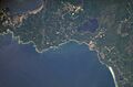
This image from the International Space Station shows the border between Schoolcraft and Delta counties.
-
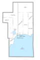
This map shows the different towns and areas within Schoolcraft County.


See also
 In Spanish: Condado de Schoolcraft para niños
