
Charlevoix County, Michigan facts for kids
Quick facts for kids
Charlevoix County
|
||
|---|---|---|

Charlevoix County Building
|
||
|
||

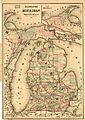
Location within the U.S. state of Michigan
|
||
 Michigan's location within the U.S. |
||
| Country | ||
| State | ||
| Founded | 1840 (created) 1869 (organized) |
|
| Named for | Pierre François Xavier de Charlevoix | |
| Seat | Charlevoix | |
| Largest city | Boyne City | |
| Area | ||
| • Total | 1,390 sq mi (3,600 km2) | |
| • Land | 416 sq mi (1,080 km2) | |
| • Water | 974 sq mi (2,520 km2) 70%% | |
| Population
(2020)
|
||
| • Total | 26,054 | |
| • Density | 62/sq mi (24/km2) | |
| Time zone | UTC−5 (Eastern) | |
| • Summer (DST) | UTC−4 (EDT) | |
| Congressional district | 1st | |
Charlevoix County (pronounced SHAR-lə-voy) is a county in the state of Michigan. It's located in the northern part of Michigan's Lower Peninsula. The main town, called the county seat, is Charlevoix. The biggest city in the county is Boyne City.
A really important feature of Charlevoix County is Lake Charlevoix. It's Michigan's third largest lake that's completely inside the state. Also, Beaver Island, the biggest island in Lake Michigan, is part of Charlevoix County. In 2020, about 26,054 people lived here.
Contents
History of Charlevoix County
How Charlevoix County Was Formed
In the early 1840s, explorers like William Austin Burt and John Mullett mapped out much of Northern Michigan. The area that is now Charlevoix County was first called Kesk-kauko in 1840. This name honored a chief from the Saginaw tribe.
A few years later, in 1843, the name was changed to Charlevoix County. It was named after Pierre François Xavier de Charlevoix. He was a Jesuit missionary from the time when France controlled this area.
The "Strangite" Mormons and County Changes
Around 1847, a group of Mormons, led by a man named James Jesse Strang, settled on Beaver Island. They created their own community there. Strang became very powerful and was even elected to the Michigan State House of Representatives.
In 1853, Strang helped pass a law that changed the size of Emmet County. This law added nearby islands and parts of other areas, including Charlevoix, to Emmet County. So, Charlevoix became a township within Emmet County.
Changes in Power and New Counties
Many non-Mormon settlers were unhappy with Strang's influence. In 1855, the Michigan Legislature changed Emmet County again. The islands, like Beaver Island, were moved into a separate county called Manitou County. This change reduced the Mormons' power in Emmet County. James Strang was attacked in 1856 and died a few weeks later.
Charlevoix County Becomes Its Own County
After these changes, there were still disagreements in Emmet County. People argued about where the county seat (the main administrative town) should be. In 1867, people voted to move the county seat to Charlevoix.
Then, in 1869, Charlevoix County officially separated from Emmet County. This meant Charlevoix became the county seat for both the new Charlevoix County and Emmet County for a short time.
Battles Over the County Seat Location
As more people moved to the eastern side of Charlevoix County, new towns grew. The Grand Rapids and Indiana Railroad was built through the area in 1873. This brought more people and changed the political power.
The towns of Boyne City and East Jordan worked together. In 1884, they managed to get enough votes to move the county seat to East Jordan. Two years later, in 1886, Boyne City convinced enough people to move the county seat to Boyne City.
Finally, in 1897, Charlevoix County made a deal. It took over three townships on Beaver Island. In return, it gave some other townships to Emmet County. This deal gave the City of Charlevoix enough votes to become the official county seat again, after 13 years.
Other Historical Facts
The Ironton Ferry started operating in 1876. This ferry crosses a part of Lake Charlevoix. The area was also once home to the Odawa people, who were skilled fishers, hunters, and fur trappers.
There are ten special historical markers in Charlevoix County. These markers tell about important places and events, such as:
- Big Rock Point Nuclear Power Plant
- Boyne City United Methodist Church
- Charlevoix Depot
- Greensky Hill Mission
- Horton Bay
- Mormon Kingdom
- Mormon Print Shop
- Norwood Township Hall
Geography of Charlevoix County
Charlevoix County covers about 1,390 square miles. Most of this area, about 974 square miles (70%), is water. The land area is about 416 square miles. It is one of the smaller counties in Michigan based on its land size.
The county has a shoreline along Lake Michigan, including parts of Grand Traverse Bay and Little Traverse Bay.
Lake Charlevoix is a very important part of the county. It has a surface area of 17,200 acres and 56 miles of shoreline. Some islands in Lake Michigan, like Gull, Hat, Pismire, and Shoe Islands, are part of the Michigan Islands National Wildlife Refuge. Two of these islands are also part of the Michigan Islands Wilderness Area.
Charlevoix County is considered to be part of the Northern Michigan region.
Neighboring Counties
Charlevoix County shares borders with other counties:
- By land:
- Emmet County (north)
- Cheboygan County (northeast)
- Otsego County (southeast)
- Antrim County (south)
- By water:
- Mackinac County (north)
- Leelanau County (southwest)
- Schoolcraft County (northwest)
Protected Areas
A part of the Michigan Islands National Wildlife Refuge is located in Charlevoix County.
Communities in Charlevoix County

Cities
- Boyne City
- Charlevoix (the county seat)
- East Jordan
Village
Civil Townships
- Bay Township
- Boyne Valley Township
- Chandler Township
- Charlevoix Township
- Evangeline Township
- Eveline Township
- Hayes Township
- Hudson Township
- Marion Township
- Melrose Township
- Norwood Township
- Peaine Township
- South Arm Township
- St. James Township
- Wilson Township
Census-Designated Places (CDPs)
These are areas that are like towns but are not officially incorporated as cities or villages.
Other Unincorporated Communities
These are smaller communities that are not officially recognized as cities, villages, or CDPs.
- Barnard
- Beaver Island
- Bonner Landing
- Boulder Park
- Burgess
- Clarion
- Martins Bluff
- Nomad
- Phelps
- Wildwood
- Zenith Heights
Indian Reservations
Charlevoix County has parts of two Odawa Indian reservations. These are lands set aside for Native American tribes.
- The Grand Traverse Band of Ottawa and Chippewa Indians has a small reservation in southwest Eveline Township.
- The Little Traverse Bay Bands of Odawa Indians has four separate reservations in the county. Three are in Hayes Township, and one is on Beaver Island in St. James Township.
Population and People
| Historical population | |||
|---|---|---|---|
| Census | Pop. | %± | |
| 1870 | 1,724 | — | |
| 1880 | 5,115 | 196.7% | |
| 1890 | 9,686 | 89.4% | |
| 1900 | 13,956 | 44.1% | |
| 1910 | 19,157 | 37.3% | |
| 1920 | 15,788 | −17.6% | |
| 1930 | 11,981 | −24.1% | |
| 1940 | 13,031 | 8.8% | |
| 1950 | 13,475 | 3.4% | |
| 1960 | 13,421 | −0.4% | |
| 1970 | 16,541 | 23.2% | |
| 1980 | 19,907 | 20.3% | |
| 1990 | 21,468 | 7.8% | |
| 2000 | 26,090 | 21.5% | |
| 2010 | 25,949 | −0.5% | |
| 2020 | 26,054 | 0.4% | |
| 2023 (est.) | 26,159 | 0.8% | |
| U.S. Decennial Census 1790–1960 1900–1990 1990–2000 2010–2018 |
|||
In 2020, the population of Charlevoix County was 26,054 people. The county has about 62 people per square mile of land.
In 2000, about 25.9% of the people in the county were under 18 years old. About 14.9% were 65 years old or older. The average age of people in the county was 39 years.
Getting Around Charlevoix County
Main Roads (State Highways)
 US 31 runs along the Lake Michigan shoreline. You can take it south to Traverse City or north to Petoskey and the Mackinac Bridge.
 US 131 goes north and south through the eastern part of the county, passing through Boyne Falls.
 M-32 starts in East Jordan and goes southeast. You can use it to reach cities like Gaylord and Alpena.
 M-66 ends at US 31 in Charlevoix. It's the longest state highway in Michigan's Lower Peninsula.
 M-75 is a highway that stays completely within Charlevoix County. It connects Boyne Falls, Boyne City, and Walloon Lake.
County Roads
Charlevoix County also has several county-designated highways:
 C-48
C-48 C-56
C-56 C-65
C-65 C-71
C-71 C-73
C-73 C-81
C-81
Airports
If you want to fly to Beaver Island, there are two airports:
- Welke Airport
- Beaver Island Airport
Ferry Services
- The Beaver Island Boat Company offers regular ferry service for cars and people from Charlevoix to Beaver Island.
- The Ironton Ferry at Ironton, Michigan crosses the south arm of Lake Charlevoix. It's a historic site and has been running since 1876.
Bus Services
- Indian Trails provides bus service between cities, with stops in Charlevoix and Boyne Falls.
- The Charlevoix County Transit System offers a "dial-a-ride" bus service across the county. You can call them to arrange a ride.
Images for kids
-
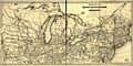
Most of present day Charlevoix County was originally part of Emmet County.
-
By 1876, the Grand Rapids and Indiana Railroad had built a line north to Petoskey with stops in Boyne Falls and Melrose. This link to cities in lower Michigan brought increased population to Charlevoix County, and new political power to the eastern part of the county.


See also
 In Spanish: Condado de Charlevoix para niños
