
Gaylord, Michigan facts for kids
Quick facts for kids
Gaylord, Michigan
|
||
|---|---|---|
.jpg)
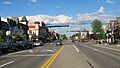
Looking east along Main Street (M-32)
|
||
|
||
| Nickname(s):
The Alpine Village
|
||

Location within Otsego County
|
||

Gaylord, Michigan
Location in Michigan

Gaylord, Michigan
Location in the United States
|
||
| Country | ||
| State | ||
| County | Otsego | |
| Platted | 1874 | |
| Incorporated | 1881 (village) 1922 (city) |
|
| Government | ||
| • Type | Council–manager | |
| Area | ||
| • Total | 5.15 sq mi (13.33 km2) | |
| • Land | 5.12 sq mi (13.27 km2) | |
| • Water | 0.03 sq mi (0.06 km2) | |
| Elevation | 1,348 ft (411 m) | |
| Population
(2020)
|
||
| • Total | 4,286 | |
| • Density | 836.46/sq mi (322.98/km2) | |
| Time zone | UTC-5 (Eastern (EST)) | |
| • Summer (DST) | UTC-4 (EDT) | |
| ZIP code(s) |
49734, 49735
|
|
| Area code(s) | 989 | |
| FIPS code | 26-31720 | |
| GNIS feature ID | 0626696 | |


Gaylord is a city in the state of Michigan, USA. It is the main city and county seat of Otsego County. In 2020, about 4,286 people lived there.
Gaylord is known as an "alpine village." Many buildings in its downtown area look like they belong in the Tyrolean Alps. The area gets a lot of snow and has mild summers. This makes it a popular spot for skiing and golf resorts. It has one of the biggest collections of these resorts in the Midwestern United States.
Contents
History
Gaylord was named after an attorney who worked for the Michigan Central Railroad. The city was first mapped out in 1874. It became a village in 1881 and a city in 1922.
Geography
Gaylord is located in Northern Michigan.
- The city covers about 4.83 square miles (12.5 square kilometers). Most of this is land.
- In winter, Gaylord gets a lot of lake effect snow. This happens because of its location near Lake Michigan. It is right in the middle of the Northern Michigan snowbelt.
- You can see signs in Gaylord that say it is on the 45th parallel north. This means it is halfway between the equator and the North Pole!
- Hartwick Pines State Park is about 28 miles (45 km) south. It has some of the last old-growth Eastern white pine forests.
- The Huron–Manistee National Forests are also nearby.
Climate in Gaylord
Gaylord has a climate with big changes between seasons. Summers are warm to hot and often humid. Winters are cold, sometimes very cold. This type of weather is called a humid continental climate.
| Climate data for Gaylord | |||||||||||||
|---|---|---|---|---|---|---|---|---|---|---|---|---|---|
| Month | Jan | Feb | Mar | Apr | May | Jun | Jul | Aug | Sep | Oct | Nov | Dec | Year |
| Mean daily maximum °F (°C) | 25.5 (−3.6) |
29.1 (−1.6) |
39.2 (4.0) |
54.3 (12.4) |
66.6 (19.2) |
75.7 (24.3) |
79.4 (26.3) |
77.0 (25.0) |
68.8 (20.4) |
55.7 (13.2) |
41.6 (5.3) |
29.5 (−1.4) |
53.5 (11.9) |
| Daily mean °F (°C) | 18.2 (−7.7) |
20.3 (−6.5) |
28.9 (−1.7) |
42.4 (5.8) |
53.9 (12.2) |
63.5 (17.5) |
67.7 (19.8) |
65.8 (18.8) |
58.1 (14.5) |
46.3 (7.9) |
34.5 (1.4) |
23.4 (−4.8) |
43.6 (6.4) |
| Mean daily minimum °F (°C) | 10.9 (−11.7) |
11.6 (−11.3) |
18.5 (−7.5) |
30.5 (−0.8) |
41.3 (5.2) |
51.3 (10.7) |
55.9 (13.3) |
54.5 (12.5) |
47.4 (8.6) |
36.9 (2.7) |
27.4 (−2.6) |
17.2 (−8.2) |
33.6 (0.9) |
| Average precipitation inches (mm) | 2.68 (68) |
1.95 (50) |
2.10 (53) |
2.36 (60) |
3.02 (77) |
2.91 (74) |
2.99 (76) |
3.64 (92) |
3.67 (93) |
3.70 (94) |
3.23 (82) |
3.05 (77) |
35.31 (897) |
| Average snowfall inches (cm) | 37.3 (95) |
24.8 (63) |
15.8 (40) |
7.4 (19) |
0.5 (1.3) |
0 (0) |
0 (0) |
0 (0) |
0 (0) |
3.2 (8.1) |
19.4 (49) |
35.1 (89) |
143.5 (364) |
| Average precipitation days (≥ 0.01 in) | 16.1 | 11.6 | 10.3 | 9.2 | 9.5 | 8.8 | 8.5 | 9.4 | 10.7 | 12.5 | 13.3 | 16.2 | 136.1 |
| Average snowy days (≥ 0.1 in) | 15.8 | 11.5 | 7.2 | 3.1 | 0.2 | 0 | 0 | 0 | 0 | 1.6 | 7.2 | 14.4 | 61 |
| Source: NOAA | |||||||||||||
Population of Gaylord

| Historical population | |||
|---|---|---|---|
| Census | Pop. | %± | |
| 1880 | 292 | — | |
| 1890 | 661 | 126.4% | |
| 1900 | 1,561 | 136.2% | |
| 1910 | 1,538 | −1.5% | |
| 1920 | 1,701 | 10.6% | |
| 1930 | 1,627 | −4.4% | |
| 1940 | 2,055 | 26.3% | |
| 1950 | 2,271 | 10.5% | |
| 1960 | 2,568 | 13.1% | |
| 1970 | 3,012 | 17.3% | |
| 1980 | 3,011 | 0.0% | |
| 1990 | 3,256 | 8.1% | |
| 2000 | 3,681 | 13.1% | |
| 2010 | 3,645 | −1.0% | |
| 2020 | 4,286 | 17.6% | |
| U.S. Decennial Census | |||
In 2010, there were 3,645 people living in Gaylord. About 27.8% of households had children under 18. The average age in the city was 39.3 years.
Getting Around Gaylord
- I-75 passes west of the city. It connects to the Mackinac Bridge in the north. To the south, it leads to Saginaw and Detroit.
- M-32 goes through the city from east to west.
- The Gaylord Regional Airport is owned by Otsego County. It helps people travel by air.
- Indian Trails offers daily bus service. You can take a bus from Gaylord to places like St. Ignace and East Lansing.
Fun Things to Do in Gaylord
.jpg)
Gaylord gets a lot of snow in winter. This is great for winter sports!
- Many old train tracks are now trails. You can use them for biking or snowmobiling. The North Central State Trail goes north to Mackinaw City.
- In the fall, you can enjoy the beautiful colors of the leaves. You can also go snowshoeing in local parks.
- Cross country skiing is very popular. There are trails at Hartwick Pines State Park and the Mason Tract Pathway.
- You can also go downhill skiing and snowboarding. Several resorts are in the area.
- In warmer weather, you can enjoy water skiing, wakeboarding, and jetskiing on Otsego Lake.
- Otsego Lake State Park is a great place for swimming, boating, and camping.
Annual Events
- Alpenfest: Every July, Gaylord hosts Alpenfest. People dress in traditional Swiss clothes. This event brings many visitors. It has carnival rides, games, music, shops, and a "Queen's Pageant." A parade happens on the last day.
- Otsego County Fair: The county fair takes place in August. It is a very exciting event. The fair has twilight shows, a "Bump n Run" event, and a "Night Of Destruction." You can enjoy delicious homemade meals and lots of free entertainment. There is also an antique fair with handmade crafts. The fair is fun for all ages and families.
Twin Town
Gaylord is connected to a town in Switzerland called Pontresina. They are "twin towns."
Media
- The local newspaper is the Gaylord Herald Times.
- You can listen to local radio stations like WMJZ 101.5 FM, which plays classic hits.
- Other stations include WBLW 88.1 FM and WPHN 90.5 FM, which play Christian music.
- WSRT 106.7 FM is a talk radio station.
- WQON 100.3 FM plays rock and roll. It also broadcasts Detroit Lions football games.
- WGRY AM/FM 101.1/1230 AM is a sports talk station. It broadcasts Detroit Tiger baseball and Detroit Red Wing hockey games.
Notable People
- Ken Borton, a politician
- Patrick R. Cooney (1934–2012), a bishop
- Bob Davis (politician) (1932–2009), a politician
- Bernard Hebda (born 1959), an archbishop
- Harry Melling (NASCAR owner) (1945–1999), a NASCAR team owner
- Steven J. Raica (born 1953), a bishop
- Robert John Rose (1930–2022), a bishop
- Claude Shannon (1916–2001), known as the "father of information theory"
- Edmund Szoka (1927–2014), a cardinal
Images for kids
-
Looking east along Main Street (M-32)
-
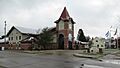
Gaylord City Hall and Police Department
-
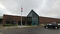
U.S. Post Office in Gaylord
-
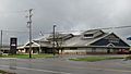
Otsego County Library in Gaylord
See also
 In Spanish: Gaylord (Míchigan) para niños
