Mackinaw City, Michigan facts for kids
Quick facts for kids
Mackinaw City, Michigan
|
||
|---|---|---|
|
Village
|
||
| Village of Mackinaw City | ||
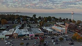
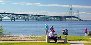
Downtown Mackinaw City looking north toward the Mackinac Bridge
|
||
|
||
| Nickname(s):
"The Tip of the Mitt"
|
||
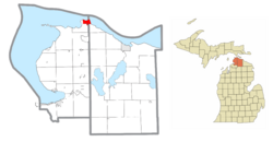
Location within Emmet County (left) and Cheboygan County (right)
|
||
| Country | United States | |
| State | Michigan | |
| Counties | Cheboygan and Emmet | |
| Townships | Mackinaw and Wawatam | |
| Settled | 1673 1715 (Fort Michilimackinac) |
|
| Platted | 1857 | |
| Incorporated | 1882 | |
| Government | ||
| • Type | Village council | |
| Area | ||
| • Total | 7.65 sq mi (19.83 km2) | |
| • Land | 3.44 sq mi (8.92 km2) | |
| • Water | 4.21 sq mi (10.91 km2) | |
| Elevation | 597 ft (182 m) | |
| Population
(2020)
|
||
| • Total | 846 | |
| • Density | 245.72/sq mi (94.88/km2) | |
| Time zone | UTC-5 (EST) | |
| • Summer (DST) | UTC-4 (EDT) | |
| ZIP code(s) |
49701
|
|
| Area code(s) | 231 | |
| FIPS code | 26-50320 | |
| GNIS feature ID | 1620662 | |
Mackinaw City (/ˈmækənɔː/ mak-Ə-naw) is a small village located at the very northern tip of Michigan's Lower Peninsula. It sits right where the Mackinac Bridge begins on the southern side. This famous bridge carries Interstate 75 across the Straits of Mackinac to St. Ignace in the Upper Peninsula.
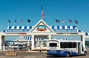
Mackinaw City and St. Ignace are also the main places where you can catch ferries to and from Mackinac Island. Because of its location and connections, Mackinaw City is one of Michigan's most popular places for tourists to visit.
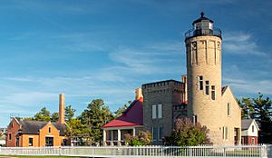
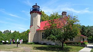
The area around Mackinaw City has many interesting historic spots. These include Fort Michilimackinac, Historic Mill Creek State Park, Old Mackinac Point Light, McGulpin Point Light, and the retired US Coast Guard Icebreaker Mackinaw.
Contents
History of Mackinaw City
The Name and Early Native American Life
The name "Mackinaw" comes from "Mackinac." This name refers to the strait between Lake Huron and Lake Michigan, and an important island there. The original name comes from the Ojibwe words mishinii-makinaang. This means "at the place of many snapping turtles."
Long ago, three main Native American tribes lived in this area. They were the Ojibwe, Ottawa (Odawa), and Potawatomi peoples. They were known as the Council of Three Fires. These tribes often visited the region, which they called Michilimackinac. They came here to fish, hunt, trade, and worship. Mackinac Island was special to them because it looked like a turtle. Native Americans had a creation story about a sacred turtle. The Straits of Mackinac were also important for the fur trade. Two main routes met here, one leading to Montreal and another to Detroit.
European Explorers and Fort Michilimackinac
The first European to see the Mackinaw City area was Jean Nicolet in 1633. He was sent by Samuel Champlain from Quebec City to explore the western Great Lakes. He also wanted to make new trading friends with the Native American tribes. Because of his reports, the French government sent settlers, missionaries, traders, and soldiers to the Great Lakes.
A priest named Jacques Marquette started a mission on Mackinac Island in 1671. This mission later moved to St. Ignace on the Michigan peninsula. In 1681, the French built Fort de Buade in St. Ignace. This was an effort to have a military presence in the Straits area. However, this fort closed in 1697.
The first European settlement in Mackinaw City itself was in 1715. The French built Fort Michilimackinac there. During the Seven Years' War, the British took control of the fort. After the American Revolutionary War, the British left the fort in 1783. Today, the site of the fort is a National Historic Landmark. It is now an open-air historical museum. Like other forts of that time, Michilimackinac was a small trading post. French civilians lived inside the fort. They gardened, hunted, and fished outside its walls.
At the end of the French and Indian War (1754–1763), the British took over the fort. They allowed the French civilians to stay inside. The French had good relationships with the Odawa and Ojibwe tribes for fur trading. On June 2, 1763, Chippewa and Fox warriors captured the fort. This was a surprise attack during a game of baggatiway (a game like lacrosse). Most of the British soldiers at the fort were captured and killed.
Europeans, including French and Scots-Irish traders, returned the next spring. They promised to trade more fairly with the Native Americans. During the American Revolutionary War, the British left the fort on the mainland. From 1779 to 1781, they moved the fort's buildings to Mackinac Island. There, they built Fort Mackinac. The British burned anything they didn't take. This was to stop American rebels from using Michilimackinac as a base.
Mackinaw City from the 1800s to Today
In 1857, two men named Conkling and Searles planned what would become Mackinaw City. They set aside the northern part of the land as a park. This was to protect the area where Fort Michilimackinac once stood. They also hoped a lighthouse would be built there.
In the second half of the 1800s, more people started visiting the Mackinaw area for summer vacations. In 1875, Mackinac National Park became the second National Park in the United States. Only Yellowstone National Park was older.
The Old Mackinac Point Lighthouse started working in 1889. A Fog Signal Building was added in 1906. This lighthouse operated until 1957. It replaced the McGulpin Point Light, which had operated from 1869 to 1906.
Mackinaw City became an important port for train ferries starting in the 1890s. Later, it became a port for ferries carrying automobiles. In the 1890s, the village had one newspaper called the Mackinaw Witness.
Auto ferries began running in the early 1900s. Camping started in Michilimackinac State Park in 1907.
When the Mackinac Bridge was finished in 1957, the Old Mackinac Point Lighthouse was turned off. At the same time, money was given to the Mackinac Island State Park Commission. They owned the land at the bridge's southern end. This money helped them start digging up the ruins of Michilimackinac. Eventually, the fort was rebuilt to look like it did in the 1770s.
Auto ferries stopped running in 1957 after the Mackinac Bridge was completed. Train ferries crossed the Straits until 1984. Today, Mackinaw City is still an important port. Tourists take passenger ferries from here to Mackinac Island. Shepler's Ferry and Star Line services operate these trips.
Over time, Mackinaw City's main business became tourism. Other jobs include services like mail, police, firefighting, and schooling. Camping in Michilimackinac State Park stopped in 1971. A Maritime Park opened in 1972 around the lighthouse. This park closed in 1990, but the Old Mackinac Point Lighthouse opened to the public in 2004. Mill Creek State Park is about five miles (8 km) southeast of the village. It is believed to be where a sawmill once operated when Mackinac Island was being settled.
Geography and Climate
Mackinaw City is located at the northernmost point of Michigan's Lower Peninsula. It lies along the Straits of Mackinac. This means it has shorelines on both Lake Huron and Lake Michigan.
The southern part of the Mackinac Bridge is located within Mackinaw City. It actually cuts through the village.
Mackinaw City's Climate
Mackinaw City has a humid continental climate. This means it has big temperature changes throughout the year. Summers are warm to hot and often humid. Winters are cold, sometimes very cold.
| Climate data for Mackinaw City, Michigan | |||||||||||||
|---|---|---|---|---|---|---|---|---|---|---|---|---|---|
| Month | Jan | Feb | Mar | Apr | May | Jun | Jul | Aug | Sep | Oct | Nov | Dec | Year |
| Mean daily maximum °C (°F) | −3 (27) |
−1 (31) |
5 (41) |
13 (55) |
20 (68) |
25 (77) |
27 (81) |
26 (79) |
21 (70) |
14 (58) |
7 (44) |
0 (32) |
13 (55) |
| Mean daily minimum °C (°F) | −15 (5) |
−15 (5) |
−9 (15) |
−3 (27) |
3 (38) |
8 (47) |
11 (52) |
10 (50) |
6 (42) |
0 (32) |
−4 (24) |
−11 (13) |
−2 (29) |
| Average precipitation mm (inches) | 46 (1.8) |
33 (1.3) |
53 (2.1) |
58 (2.3) |
64 (2.5) |
84 (3.3) |
86 (3.4) |
97 (3.8) |
89 (3.5) |
61 (2.4) |
56 (2.2) |
48 (1.9) |
770 (30.4) |
| Source: Weatherbase | |||||||||||||
Population of Mackinaw City
| Historical population | |||
|---|---|---|---|
| Census | Pop. | %± | |
| 1890 | 333 | — | |
| 1900 | 564 | 69.4% | |
| 1910 | 697 | 23.6% | |
| 1920 | 679 | −2.6% | |
| 1930 | 875 | 28.9% | |
| 1940 | 922 | 5.4% | |
| 1950 | 970 | 5.2% | |
| 1960 | 934 | −3.7% | |
| 1970 | 810 | −13.3% | |
| 1980 | 820 | 1.2% | |
| 1990 | 875 | 6.7% | |
| 2000 | 859 | −1.8% | |
| 2010 | 806 | −6.2% | |
| 2020 | 846 | 5.0% | |
| U.S. Decennial Census | |||
As of the 2020 census, there were 846 people living in Mackinaw City.
Transportation in Mackinaw City
Main Highways
 I-75 is a major highway that runs north and south through Michigan. It goes through cities like Detroit and Flint. It then crosses the Mackinac Bridge right after Mackinaw City. It continues into the Upper Peninsula to Sault Ste. Marie.
 US 23 starts in Mackinaw City. It is called the "Sunrise Side Coastal Highway." It follows the Lake Huron shoreline south towards Cheboygan.
 US 31 ends near Mackinaw City. It goes south along the Lake Michigan coast. It passes through cities like Petoskey and Traverse City.
Ferry Services
Two ferry companies operate from Mackinaw City. They take tourists and others to Mackinac Island. These companies are Shepler's Ferry and Star Line Ferry.
Bus Services
Indian Trails offers daily bus service. You can travel between St. Ignace and East Lansing, Michigan. You can also go between St. Ignace and Bay City, Michigan. You can switch between these bus lines in Mackinaw City.
Past Railways and Trails
In the past, train lines like the Michigan Central and Pennsylvania Railroad served Mackinaw City. Passenger trains like the Northern Arrow came here. Over time, train service decreased. The state tried to help by creating the Michigan Northern Railway in the 1980s. However, passenger and freight services were not making money. So, the state stopped its support in 1984. The tracks were later removed.
The old Michigan Central line in Mackinaw City was turned into a trail. This was part of the Rails to Trails program. In 2008, it became the North Central State Trail. This trail now goes from Mackinaw City to Gaylord.
Airports Nearby
The closest airports with regular passenger flights are:
- Pellston Regional Airport
- Cherry Capital Airport in Traverse City
- Alpena County Regional Airport (all in the Lower Peninsula)
- Chippewa County International Airport near Sault Ste. Marie (in the Upper Peninsula)
Education
Mackinaw City Public Schools provides education for students in Mackinaw City. The town has two schools in one building. There is an elementary school for grades K-5. There is also a junior-senior high school for grades 6–12.
Religious Groups
Mackinaw City is part of the Roman Catholic Diocese of Gaylord. It is also part of the Episcopal Diocese of Eastern Michigan.
See also
 In Spanish: Mackinaw City para niños
 | Isaac Myers |
 | D. Hamilton Jackson |
 | A. Philip Randolph |


