Mackinaw Township, Michigan facts for kids
Quick facts for kids
Mackinaw Township, Michigan
|
|
|---|---|

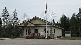
Mackinaw Township Hall
|
|

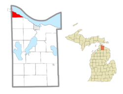
Location within Cheboygan County (red) and a portion of the administered village of Mackinaw City (pink)
|
|
| Country | United States |
| State | Michigan |
| County | Cheboygan |
| Area | |
| • Total | 12.4 sq mi (32.2 km2) |
| • Land | 11.4 sq mi (29.6 km2) |
| • Water | 1.0 sq mi (2.7 km2) |
| Elevation | 692 ft (211 m) |
| Population
(2020)
|
|
| • Total | 491 |
| • Density | 39.49/sq mi (15.25/km2) |
| Time zone | UTC-5 (Eastern (EST)) |
| • Summer (DST) | UTC-4 (EDT) |
| ZIP code(s) |
49701, 49718, 49721
|
| Area code(s) | 231 |
| FIPS code | 26-50300 |
| GNIS feature ID | 1626655 |
Mackinaw Township is a small community in Cheboygan County, Michigan. It is a type of local government area called a civil township. In 2020, about 491 people lived here. It is known for its beautiful location near the Straits of Mackinac.
Contents
Places in Mackinaw Township
Freedom
Freedom is a small, unincorporated community. It sits right on the shore of the Straits of Mackinac. This area is in the northeast part of the township. You can find it along U.S. Highway 23. Freedom is about 3.5 miles (5.6 km) southeast of Mackinaw City.
Mackinaw City
Mackinaw City is a village that is partly located in Mackinaw Township. It is in the northwest part of the township. This village is also partly in Wawatam Township.
Geography of Mackinaw Township
Mackinaw Township is located in the very northwest corner of Cheboygan County. The Straits of Mackinac are to its northeast. Emmet County borders it to the west.
The township covers a total area of about 12.4 square miles (32.2 km²). Most of this area is land, about 11.4 square miles (29.6 km²). The rest is water, which is about 1.0 square mile (2.7 km²). This means about 8.33% of the township's total area is water.
People of Mackinaw Township
In the year 2000, there were 576 people living in Mackinaw Township. These people lived in 260 households. About 165 of these households were families.
The population density was about 130 people per square mile (50.3 people per km²). There were 415 housing units in the township.
Most of the people living in the township were White (93.40%). About 2.95% were Native American. Another 3.65% were from two or more racial backgrounds. A very small number, 0.17%, were Hispanic or Latino.
About 21.9% of households had children under 18 living with them. About 51.9% were married couples. Around 31.2% of all households were individuals living alone. About 15.0% had someone 65 years or older living by themselves.
The average household had 2.22 people. The average family had 2.71 people.
The population was spread out by age. About 20.8% were under 18 years old. About 18.9% were 65 years or older. The average age in the township was 45 years. For every 100 females, there were about 88.9 males.
See also
 In Spanish: Municipio de Mackinaw (Míchigan) para niños
 | George Robert Carruthers |
 | Patricia Bath |
 | Jan Ernst Matzeliger |
 | Alexander Miles |


