Eveline Township, Michigan facts for kids
Quick facts for kids
Eveline Township, Michigan
|
|
|---|---|

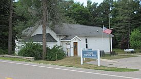
Eveline Township Hall
|
|

|
|
| Country | United States |
| State | Michigan |
| County | Charlevoix |
| Area | |
| • Total | 36.75 sq mi (95.18 km2) |
| • Land | 25.81 sq mi (66.85 km2) |
| • Water | 10.94 sq mi (28.33 km2) |
| Elevation | 735 ft (224 m) |
| Population
(2020)
|
|
| • Total | 1,515 |
| • Density | 41.224/sq mi (15.917/km2) |
| Time zone | UTC-5 (Eastern (EST)) |
| • Summer (DST) | UTC-4 (EDT) |
| ZIP code(s) | |
| Area code(s) | 231 |
| FIPS code | 26-26680 |
| GNIS feature ID | 1626255 |
Eveline Township is a small community in Charlevoix County, Michigan. It's like a local government area that helps manage things for the people living there. In 2020, about 1,515 people called Eveline Township home.
Contents
Exploring Eveline Township
Eveline Township is home to several interesting places, some of which are still active and others are historic.
Towns and Historic Places
- Advance is a community in the eastern part of the township. It's a "census-designated place," which means it's a specific area that the government counts for population, even though it's not an official town. You can find it at 45°13′17″N 85°04′39″W / 45.22139°N 85.07750°W.
- Bedwin was a historic settlement. It was named after a store owner, Robert Bedwin. This place even had its own post office for a short time in the 1880s.
- Eveline was another historic settlement right in the middle of the township. It was named after the township itself. A post office called Eveline opened here in 1877, but it's not there anymore.
- Ironton is another community and census-designated place within the township. It's located at 45°15′28″N 85°11′26″W / 45.25778°N 85.19056°W.
- Holy Island was a historic settlement. It was started by a person named James Strang on Holy Island way back in 1855.
- Raymond was a community that existed for a very short time. It had a post office that operated for just about a year in the early 1890s.
- Rock Elm was a former settlement along the south arm of Lake Charlevoix. It started with a rural post office in 1876, but that post office closed in 1886.
Geography and Nature
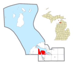
Eveline Township covers an area of about 36.75 square miles (95.18 square kilometers). A big part of this area, about 10.94 square miles (28.33 square kilometers), is water!
Water and Land
Eveline Township is located along the southern coast of Lake Charlevoix. This lake is quite large and divides the township into two parts. There isn't a direct road connecting these two sides. Instead, people use the Ironton Ferry to cross a narrow part of the lake. The township also includes Holy Island, which is in Lake Charlevoix.
Main Roads
- Michigan Highway 66 (M-66) runs through the western part of the township. It follows along the beautiful Lake Charlevoix.
Who Lives Here?
In 2000, there were about 1,560 people living in Eveline Township. Most families living here were married couples. The average age of people in the township was 44 years old.
Education for Kids
Eveline Township is served by three different school districts. This means that depending on where you live in the township, you might go to a different school!
- Most of the township is served by East Jordan Public Schools.
- The eastern part, including the community of Advance, is served by Boyne City Public Schools.
- The northwest corner, including the community of Ironton, is served by Charlevoix Public Schools.
See also
 In Spanish: Municipio de Eveline para niños


