Norwood, Michigan facts for kids
Quick facts for kids
Norwood, Michigan
|
|
|---|---|

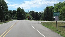
Road signage along Norwood Road
|
|

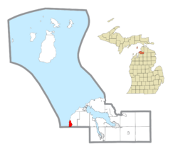
Location within Charlevoix County
|
|
| Country | United States |
| State | Michigan |
| County | Charlevoix |
| Township | Norwood |
| Settled | 1867 |
| Area | |
| • Total | 2.03 sq mi (5.26 km2) |
| • Land | 2.03 sq mi (5.26 km2) |
| • Water | 0.00 sq mi (0.00 km2) |
| Elevation | 656 ft (200 m) |
| Population
(2020)
|
|
| • Total | 144 |
| • Density | 70.90/sq mi (27.37/km2) |
| Time zone | UTC-5 (Eastern (EST)) |
| • Summer (DST) | UTC-4 (EDT) |
| ZIP code(s) |
49720 (Charlevoix)
|
| Area code(s) | 231 |
| FIPS code | 26-59320 |
| GNIS feature ID | 0633765 |
Norwood is a small community in Charlevoix County, Michigan. It is called an "unincorporated community" and a "census-designated place" (CDP). This means it's a recognized area that isn't officially a city or town, but the government counts its population.
In 2020, about 144 people lived in Norwood. It is located right on the shores of Lake Michigan, within Norwood Township.
Contents
History of Norwood
Norwood began to be settled around 1867. Two men, Orvis Wood and Lucius Pearl, along with Orin Adams, built a dock and a sawmill here. At that time, this area was part of Emmet County. Charlevoix County, where Norwood is now, was not yet officially set up until 1869.
The next year, in 1868, William Harris built a hotel. Norwood quickly became an important place for shipping goods. Harris also became the first postmaster when a post office opened on February 1, 1868. The name "Norwood" was chosen because the community was located in the "northern woods." The post office served the community until April 30, 1913.
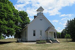
Norwood Schoolhouse
The Norwood School District No. 1 was created in 1867. A wooden schoolhouse was built in 1869. The building you see today was built in 1890.
Because fewer and fewer students attended, the school district joined with the Charlevoix School District in 1957. After that, the building was used as a church. In 2004, the Norwood Area Historic Society bought the old schoolhouse and restored it. In 2017, this historic schoolhouse was recognized as a Michigan State Historic Site.
Official Recognition
For the 2010 census, Norwood was officially listed as a new census-designated place (CDP). This means it now has clear boundaries and its population is counted separately. Norwood uses the same ZIP Code, 49720, as the nearby city of Charlevoix.
Geography
Norwood is a small area. According to the U.S. Census Bureau, the Norwood CDP covers about 2.03 square miles (5.26 km2) of land. There is no water area within its official boundaries.
Main Roads
Population Information
| Historical population | |||
|---|---|---|---|
| Census | Pop. | %± | |
| 2010 | 142 | — | |
| 2020 | 144 | 1.4% | |
| U.S. Decennial Census | |||
The population of Norwood has stayed quite small. In 2010, there were 142 people. By 2020, the population had grown slightly to 144 people.
Education
Students living in Norwood attend schools in the Charlevoix Public Schools district. These schools are located to the northeast in Charlevoix.
Famous People from Norwood
- Ding Darling was a well-known cartoonist. He was born in Norwood.
See also
 In Spanish: Norwood (Míchigan) para niños
 | Isaac Myers |
 | D. Hamilton Jackson |
 | A. Philip Randolph |


