Beaver Island (Lake Michigan) facts for kids
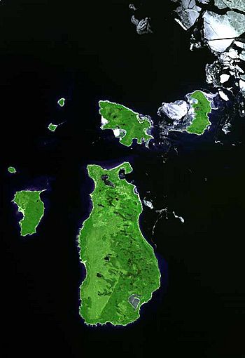
Beaver Island, as seen from space
|
|
|
Location of Beaver Island in Michigan
|
|
| Geography | |
|---|---|
| Location | Lake Michigan |
| Coordinates | 45°40′N 85°32′W / 45.667°N 85.533°W |
| Area | 55.8 sq mi (145 km2) |
| Highest elevation | 696 ft (212.1 m) |
| Administration | |
| State | Michigan |
| County | Charlevoix County |
| Townships | Peaine Township St. James Township |
| Demographics | |
| Population | 657 (2010) |
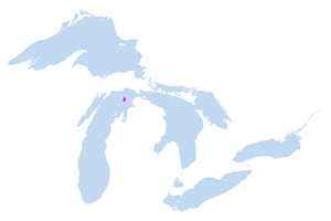
Beaver Island is a beautiful island located in Lake Michigan. It's part of the U.S. state of Michigan. This island is quite large, covering about 55.8 square miles. It's the biggest island in Lake Michigan. It's also the third largest island in Michigan, after Isle Royale and Drummond Island.
Beaver Island is about 32 miles away from the city of Charlevoix. In 2010, about 657 people lived there. In the past, Beaver Island was home to a very special religious group. They were led by a man named "King Strang". Later, many Irish American families moved to the island. Today, Beaver Island is a popular spot for vacations and tourists. Parts of the island are protected as a Beaver Islands State Wildlife Research Area. This helps keep its nature safe.
Contents
Island History: A Unique Past
King Strang's Island Kingdom
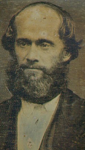
Today, Beaver Island is known for its pretty beaches and quiet forests. But a long time ago, it was the site of a very unusual "kingdom." This kingdom was led by a man named James J. Strang. He was a leader in the Latter Day Saint movement.
After the death of the movement's founder, Joseph Smith, most followers chose Brigham Young as their new leader. But some followed James J. Strang. Strang started his own church, the Church of Jesus Christ of Latter Day Saints (Strangite). He believed his church was the true continuation of Smith's original church. His group first settled in Wisconsin in 1844.
In 1848, Strang and his followers moved to Beaver Island. They were looking for a safe place. At that time, mostly Irish immigrants lived on the island. Strang's followers, called Strangites, grew strong. They became an important group in the area. They built the town of St. James, named after Strang. They also built a main road called "King's Highway." This road is still used today. The Strangites worked hard to build homes and farms. They wanted to live on the island permanently.
Strang was even elected to the Michigan State House of Representatives twice. He started the first newspaper in Northern Michigan, called the Northern Islander. During his time in government, he made the island the center of a new county. This county was called Manitou County. It included Beaver Island and other nearby islands.
Strang declared himself a polygamist, meaning he had multiple wives. He had five wives and fourteen children. In 1850, Strang announced he was a king, but of his church, not the island itself. He had a special crowning ceremony on July 8, 1850. He wore a crown, a red robe, and carried a scepter. The building where he was crowned is gone now. But a printing shop built by his followers still stands. It is now a museum about the island's history.
Strang and his followers often had disagreements with other people on the island. Strang was seen as very powerful. There were often fights between the two groups. Many Irish immigrants left for nearby Mackinaw Island. Strangites became very involved in local government.
Many people didn't like Strang's strong rule. On June 16, 1856, a US Navy ship came to St. James harbor. Strang was invited onto the ship. As he walked on the dock, two men shot him. They then ran to the ship, which took them away. Strang died from his injuries on July 9, 1856.
After Strang's death, groups from other islands came to Beaver Island. They made the Strangites leave. About 2,600 Strangites left Beaver Island. The local government became very weak. In 1895, Beaver Island became part of Charlevoix County.
Beaver Island: America's Emerald Isle
After the Strangites left, Irish fishermen quickly moved to Beaver Island. They came from other islands and from Ireland itself. Their community grew and became very unique. The island was isolated, which helped them keep their traditions. For many years, people spoke Gaelic (the Irish language) in church and in daily life.
By the 1880s, Beaver Island was a huge supplier of freshwater fish in the USA. But too much fishing and new technology ended this by 1900.
Two other famous people lived on the island. Father Peter Gallagher was a priest from 1865 to 1898. He was a very strong leader in the community. Another person was Feodor Protar. He arrived in 1893. He was a follower of the Russian writer Leo Tolstoy. Protar was a local doctor and a friend to everyone. He lived alone in a cabin. Protar died in 1925 and was much admired.
Logging, or cutting down trees, was always important to the island's economy. It grew a lot in 1901 with a new logging company. Fishing was still the main activity. But in the 1940s, there were fewer fish. Many people left the island. Then, in the 1970s, tourism brought new life to the island. Today, Beaver Island is a popular place for people to visit and relax.
In 1938, a man named John W. Green lived on Beaver Island. He was recorded singing old traditional songs. You can find these songs on the Library of Congress website.
Island Geography and Nature
Beaver Island is about 13 miles long and 3 to 6 miles wide. It is part of Charlevoix County, Michigan. The island is mostly flat and sandy. It has large areas of forest. In 2010, 657 people lived there permanently.
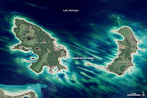
The northern part of the island is more populated. This area is called Saint James Township. It also includes other small islands like Garden Island and High Island. These smaller islands are not permanently inhabited. The rest of Beaver Island is Peaine Township. This part has large areas of state land. These lands are managed as part of the Beaver Islands State Wildlife Research Area. This area is mostly undeveloped.
The island has several small to medium-sized lakes. These include Lake Geneserath, Greenes Lake, Fox Lake, and Font Lake. There are also two named streams. The Jordan River flows into Sand Bay. Iron Ore Creek flows into Iron Ore Bay.
Beaver Island Climate
Beaver Island has a climate with big changes in temperature. Summers are warm to hot and often humid. Winters are cold, sometimes very cold. This type of climate is called a humid continental climate.
| Climate data for Beaver Island | |||||||||||||
|---|---|---|---|---|---|---|---|---|---|---|---|---|---|
| Month | Jan | Feb | Mar | Apr | May | Jun | Jul | Aug | Sep | Oct | Nov | Dec | Year |
| Record high °F (°C) | 54 (12) |
59 (15) |
79 (26) |
82 (28) |
88 (31) |
91 (33) |
94 (34) |
93 (34) |
90 (32) |
81 (27) |
69 (21) |
60 (16) |
94 (34) |
| Mean daily maximum °F (°C) | 26.5 (−3.1) |
28.2 (−2.1) |
36.8 (2.7) |
50.2 (10.1) |
62.1 (16.7) |
71.1 (21.7) |
75.9 (24.4) |
75.2 (24.0) |
67.0 (19.4) |
54.7 (12.6) |
42.6 (5.9) |
32.0 (0.0) |
52.0 (11.1) |
| Mean daily minimum °F (°C) | 14.7 (−9.6) |
14.4 (−9.8) |
21.1 (−6.1) |
32.0 (0.0) |
41.6 (5.3) |
51.2 (10.7) |
57.6 (14.2) |
58.2 (14.6) |
51.9 (11.1) |
41.4 (5.2) |
31.6 (−0.2) |
22.0 (−5.6) |
36.6 (2.6) |
| Record low °F (°C) | −23 (−31) |
−25 (−32) |
−21 (−29) |
2 (−17) |
21 (−6) |
31 (−1) |
35 (2) |
36 (2) |
27 (−3) |
21 (−6) |
7 (−14) |
−10 (−23) |
−25 (−32) |
| Average precipitation inches (mm) | 2.04 (52) |
1.21 (31) |
1.81 (46) |
2.59 (66) |
2.95 (75) |
2.76 (70) |
2.59 (66) |
2.96 (75) |
3.71 (94) |
3.04 (77) |
2.68 (68) |
2.15 (55) |
30.48 (774) |
| Average snowfall inches (cm) | 23.1 (59) |
14.6 (37) |
10.7 (27) |
3.6 (9.1) |
0.2 (0.51) |
0 (0) |
0 (0) |
0 (0) |
0 (0) |
0.1 (0.25) |
4.6 (12) |
18.3 (46) |
75.0 (191) |
| Average precipitation days (≥ 0.01 in) | 10 | 7 | 7 | 8 | 9 | 9 | 8 | 8 | 9 | 9 | 9 | 10 | 101 |
| Source 1: NOAA (normals, 1981–2010) | |||||||||||||
| Source 2: Western Regional Climate Center (extremes and precipitation 1952–present) | |||||||||||||
Island Economy and Fun Activities

In the past, Beaver Island's main jobs were fishing, logging, and farming. Today, the economy focuses on government services, tourism, and building homes. There are many fun things to do on the island. You can enjoy the harbor, beaches, and inland lakes. The state forest covers much of the island. There's a golf course, nature trails, restaurants, hotels, and a marina.
The island calls itself "America's Emerald Isle." This is because many residents have Irish ancestry.
Central Michigan University has a research center on the island. It's called the "CMU Biological Station." Students and researchers come here for classes and workshops. CMU also owns an old Coast Guard Boathouse and part of Miller's Marsh.
Getting to Beaver Island
Two small airlines fly to Beaver Island: Island Airways and Fresh Air Aviation. Their planes are small, carrying 6–10 passengers. The flight takes about 20 minutes. Flights are available many times a day all year. You can often book a flight with short notice. Your luggage is usually included in the ticket price. There's a weight limit per person. Extra luggage costs more based on its weight. You can also bring pets, with prices based on their size.
Island Airways flies from Charlevoix to Welke Airport. This airport is about one mile south of St. James. Fresh Air Aviation flies from Charlevoix to Peaine Township Airport (KSJX). This airport is on the western side, about 4 miles from St. James.
The Beaver Island Boat Company offers ferry service for cars and people. They sail from Charlevoix most of the year. Daily service is available from May through September. Limited service runs from October to mid-December. The ferry is closed from January to March. It's a good idea to check the weather before you go. Rough waves can make people seasick. If you want to bring your car, you need to book ahead. Space on the ferry is limited.
There are two ferry boats: The Emerald Isle and the Beaver Islander. The Beaver Islander is smaller. The trip takes about two to two and a half hours. The time depends on the weather and which ferry you take. You can bring dogs, bikes, canoes, kayaks, and motorcycles on the ferry for an extra fee.
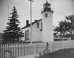
There are two lighthouses on the island:
- Beaver Island Harbor Light (St. James Light) was built in 1870. It's on the northern part of the island. It still helps boats navigate today.
- Beaver Island Head Lighthouse was built in 1858. It's on the southern part of the island. It stopped being used in 1961.
Beaver Island Archipelago
Beaver Island is part of a group of islands called the Beaver Islands archipelago. Here are some of the islands, from largest to smallest:
- Beaver Island
- Garden Island
- High Island
- South Fox Island
- Hog Island
- North Fox Island
- Gull Island
- Whiskey Island
- Squaw Island
- Trout Island
- Grape Island
- Hat Island
- Shoe Island
- Pismire Island
Some of these islands, like Gull, Hat, Pismire, and Shoe Islands, are part of a special wildlife refuge. It's called the Lake Michigan division of the Michigan Islands National Wildlife Refuge. They are managed to protect nature. Pismire and Shoe Islands are also part of the Michigan Islands Wilderness Area.
Images for kids
 | Victor J. Glover |
 | Yvonne Cagle |
 | Jeanette Epps |
 | Bernard A. Harris Jr. |


