Hog Island (Michigan) facts for kids
| Geography | |
|---|---|
| Location | Lake Michigan |
| Coordinates | 45°47′30″N 85°21′58″W / 45.79167°N 85.36611°W |
| Area | 3.24 sq mi (8.4 km2) |
| Highest elevation | 587 ft (178.9 m) |
| Administration | |
| State | Michigan |
| County | Charlevoix County |
| Township | St. James Township |
| Demographics | |
| Population | Uninhabited |
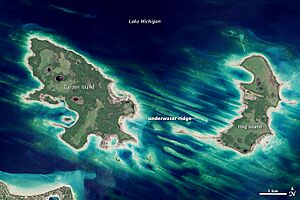
Hog Island is a large, empty island in Lake Michigan. It covers about 2,075 acres (8 square kilometers). This makes it the fourth biggest island in the Beaver Island group of islands.
The U.S. state of Michigan owns Hog Island. It is part of the Beaver Islands State Wildlife Research Area. The Michigan Department of Natural Resources looks after it.
Contents
Island Geography
Hog Island is part of the Beaver Island archipelago. An archipelago is a group of islands. These islands are in the northern part of Lake Michigan. The islands are made of strong rock. This rock stayed above the water when glaciers carved out the lake basin.
Hog Island is about 4 miles (6.5 kilometers) long. It stretches from north to south. The island is located near the coast of Emmet County, Michigan.
Island Terrain and Access
The land on Hog Island is low and swampy. This makes it very interesting to naturalists. Naturalists are people who study nature. It is one of the most untouched islands in Lake Michigan.
Hog Island is quite hard to reach, even by boat. You can get close from Hog Island Point State Forest. This forest is just off US Highway 2. It is seven miles from Naubinway, Michigan.
Plants and Animals
The island has many wetlands. Wetlands are areas where the land is wet, like swamps. These wetlands are important places for fish to lay eggs. Yellow perch and smallmouth bass use them as spawning grounds.
Birds that eat fish also live here. The common tern is one such bird. It is listed as a threatened species in Michigan. This means its numbers are low and it needs protection.
Special Plants on the Island
Three special plant types grow on Hog Island. They are called riparian species. This means they grow near water. These plants are:
- Houghton's goldenrod
- The Lake Huron tansy
- Pitcher's thistle
All three of these plants are also listed as threatened in Michigan. This means they are rare and need to be protected. The island also has old hardwood and softwood groves. These are groups of old trees.
View

 | Percy Lavon Julian |
 | Katherine Johnson |
 | George Washington Carver |
 | Annie Easley |


