Garfield Township, Mackinac County, Michigan facts for kids
Quick facts for kids
Garfield Township, Michigan
|
|
|---|---|

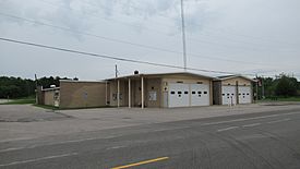
Garfield Township Municipal Building
|
|

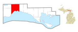
Location within Mackinac County
|
|
| Country | United States |
| State | Michigan |
| County | Mackinac |
| Area | |
| • Total | 137.56 sq mi (356.28 km2) |
| • Land | 134.52 sq mi (348.41 km2) |
| • Water | 3.04 sq mi (7.87 km2) |
| Elevation | 663 ft (202 m) |
| Population
(2020)
|
|
| • Total | 1,166 |
| • Density | 8.52/sq mi (3.29/km2) |
| Time zone | UTC-5 (Eastern (EST)) |
| • Summer (DST) | UTC-4 (EDT) |
| ZIP Codes | |
| Area code(s) | 906 |
| FIPS code | 26-097-31620 |
| GNIS feature ID | 1626339 |
Garfield Township is a community located in Mackinac County, Michigan, in the United States. It's a type of local government area called a civil township. In 2020, about 1,166 people lived here.
Contents
Exploring Garfield Township's Location
Garfield Township is in the western part of Mackinac County. It shares borders with other townships in Mackinac County, like Portage Township and Newton Township to the west, and Hudson Township to the east. To the north, it borders Pentland Township in Luce County. The southern edge of the township is right along the shore of Lake Michigan.
The Northernmost Point of Lake Michigan
Garfield Township is home to a special spot: the northernmost point of Lake Michigan. This important location is near Naubinway. It was recognized as a Michigan State Historic Site in 1964. This point was very important in history. It helped define the western border of the Michigan Territory when it was first created in 1805. Everything west of this point was part of the Indiana Territory until Michigan's territory grew in 1818.
Land and Water Areas
The United States Census Bureau tells us that Garfield Township covers a total area of about 137.56 square miles (356.28 square kilometers). Most of this area, about 134.52 square miles (348.41 square kilometers), is land. The rest, about 3.04 square miles (7.87 square kilometers), is water, making up about 2.26% of the total area.
Communities in Garfield Township
Garfield Township has several smaller communities within its borders. These are often called unincorporated communities because they don't have their own separate local government.
- Engadine is a community located along M-117 and H-40. It's about 1 mile (1.6 km) north of U.S. Route 2. Engadine started as a logging settlement called "Kennedy Siding." It got its first post office in 1889, and its name changed to Engadine in 1893. The 49827 ZIP Code for Engadine covers most of Garfield Township. It also includes parts of Portage Township and Newton Township.
- Gilchrist is another community on H-40 (Hiawatha Trail). It's about 6 miles (9.7 km) east of Millecoquins and 3.5 miles (5.6 km) west of Garnet. Gilchrist was also a logging town and had a train station on the Minneapolis, St. Paul and Sault Ste. Marie Railroad. It had a post office for a few years, named after John Gilchrist, who owned land there.
- Millecoquins is a community located on H-40 (Hiawatha Trail). It's about 3 miles (4.8 km) east of Engadine and 9.5 miles (15.3 km) west of Garnet. This community is at the southern end of Millecoquins Lake. The name Millecoquins comes from a French phrase meaning "a thousand thieves." However, it was originally based on Native American terms like Manana koking or Minakoking, which meant a place with lots of hardwood trees.
- Naubinway is a community right on U.S. Route 2 along the Lake Michigan shoreline. It's also a census-designated place, which means it's a specific area identified for census purposes. Naubinway got its post office in 1879. The 49762 ZIP Code for Naubinway serves the southern part of Garfield Township. It also covers a larger area to the east, including most of Hudson Township, all of Hendricks Township, and a small part of Moran Township. The Garlyn Zoo, which is in Hudson Township, also uses the Naubinway ZIP Code. Just half a mile south of the community is Naubinway Island.
Getting Around Garfield Township
There are a few important ways to travel through Garfield Township.
Main Roads
 US 2 is a major highway that runs east to west along the southern edge of the township, right next to the Lake Michigan coastline.
 H-40, also known as Hiawatha Trail, is another important road that goes east to west through the middle of the township.
Bus Services
- Indian Trails provides daily bus service that stops in Engadine. This bus service connects places like St. Ignace and Ironwood, Michigan.
See also
 In Spanish: Municipio de Garfield (condado de Mackinac) para niños
 | Misty Copeland |
 | Raven Wilkinson |
 | Debra Austin |
 | Aesha Ash |


