
Engadine, Michigan facts for kids
Quick facts for kids
Engadine, Michigan
|
|
|---|---|
.jpg)
Melville Street (H-40) looking west toward M-117
|
|

Engadine, Michigan
Location in Michigan

Engadine, Michigan
Location in the United States
|
|
| Country | United States |
| State | Michigan |
| County | Mackinac |
| Township | Garfield |
| Settled | 1889 |
| Established | 1894 |
| Elevation | 673 ft (205 m) |
| Time zone | UTC-5 (Eastern (EST)) |
| • Summer (DST) | UTC-4 (EDT) |
| ZIP code(s) |
49827
|
| Area code(s) | 906 |
| GNIS feature ID | 625593 |
Engadine (/ˈɛnɡədaɪn/ en-GƏ-dyne) is a small community in Mackinac County, Michigan, in the United States. It's called an "unincorporated community," which means it doesn't have its own official city government or strict borders. Even so, Engadine has its own post office with a special ZIP code, 49827. It's a quiet place located within Garfield Township.
Contents
Engadine's Early History
Engadine's story is much like that of nearby Naubinway. The first European family to settle here was William Boucha's, who arrived in the Naubinway area in 1843. Both Engadine and Naubinway started as busy logging towns around 1880. This was when the "lumber boom" began in Michigan's Upper Peninsula. These communities grew quickly and became important centers for large logging companies.
The new community was first named Kennedy. Its post office opened on August 23, 1889. It was also known as Kennedy Siding because it was next to a railway line. The Canadian Pacific Railway built tracks through the area as early as 1888. The community grew up around this railway. Engadine even had its own train station, connecting it to many other logging towns in the Upper Peninsula.
An early settler and lumberman named Sam Peterson moved to the area. He suggested changing the name from Kennedy to Engadine. He had lived in the beautiful Engadine valley in Switzerland. So, the community and post office officially changed their names to Engadine on December 2, 1893. The post office has been open ever since and is now at 104 Melville Street.
Besides the railway, logs were also taken to Naubinway. From there, they were shipped across the Great Lakes. The railway line is still active today, run by Canadian National Railway. However, trains no longer stop in Engadine. In the 1940s, U.S. Route 2 was built and rerouted to pass just south of Engadine. Around the same time, M-117 was created. This short road connects U.S. Route 2 north to M-28 near Newberry. Engadine is the only community located along M-117. The Engadine Cemetery, also called the Garfield Cemetery, is just north of the town center. It's still in use today, with graves dating back to 1911.
Hiawatha Sporting Club
The Hiawatha Sporting Club was started in Engadine in 1927. A famous doctor named William McNamara founded it. He bought about 54.5 square miles (141 square kilometers) of land. His goal was to create a place for fishing and hunting. He also wanted to protect the environment after the logging industry ended. It became one of Michigan's largest and most exclusive private clubs. The club owned many miles of Lake Michigan shoreline. It also had several lakes stretching from Engadine through Naubinway.
In 1931, the club bought an empty store in Engadine. They moved it onto the club's property to use as a commissary, which is like a store for supplies. This building is now known as the Hiawatha Sportsman's Club 1931 Maintenance Building and Commissary. It was listed on the National Register of Historic Places in 2011. Today, it's used as a recreational building. The Hiawatha Sporting Club is still an active private club, with its main office in Engadine.
Engadine's Location and Surroundings
Engadine is located in Garfield Township. This is in Michigan's Upper Peninsula. It's about 40 miles (64 km) east of the city of Manistique. The community is mainly found along the southern part of M-117 and Melville Street. Melville Street is also known as County Highway 40 (H-40) east of M-117. H-40 goes east for about 52.6 miles (84.7 km) to M-48 in Chippewa County.
Soon after leaving the community to the east and west, Melville Street changes its name to Hiawatha Trail. Parts of the area around Engadine are within the Lake Superior State Forest. The community is about 5 miles (8 km) north of Lake Michigan. It sits at an elevation of 673 feet (205 meters) above sea level.
The village of Newberry is the closest larger community, about 20 miles (32 km) north. Other smaller towns nearby include Curtis and Millecoquins to the northwest. Gould City is to the southwest, and Naubinway is to the southeast.
Engadine has its own post office that uses the 49827 ZIP Code. This post office serves a much larger area than just the community itself. It covers most of Garfield Township. It also includes small parts of northeastern Newton Township and eastern Portage Township. The Garfield Township Municipal Building, which is the local government office, is in the center of Engadine at 6760 M-117.
Education in Engadine
Engadine gives its name to its own school district, called Engadine Consolidated Schools. The district has one main campus located at 13920 Melville Street. This campus is just east of M-117 within the community. The school offers education from pre-kindergarten all the way through 12th grade. In the 2019–2020 school year, 344 students were enrolled here.
Engadine Consolidated Schools covers a very large area of about 445.9 square miles (1,155 square kilometers). This makes it one of the top 10 largest school districts in Michigan by area. It is the biggest school district in Mackinac County. It serves most of the western half of the county. This includes all of Garfield Township, Hendricks Township, Newton Township, and a small eastern part of Portage Township.
Images for kids
-
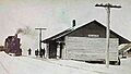
Historic image of the former Engadine train station
-
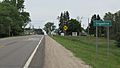
Road signage looking north along M-117 -
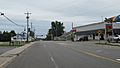
Looking south along M-117 -
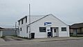
U.S. Post Office in Engadine -
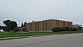
Engadine Consolidated Schools


.jpg)
