
Mackinac County, Michigan facts for kids
Quick facts for kids
Mackinac County
|
|
|---|---|

The Grand Hotel on Mackinac Island
|
|

Location within the U.S. state of Michigan
|
|
 Michigan's location within the U.S. |
|
| Country | |
| State | |
| Founded | October 26, 1818 organized 1849 |
| Named for | Straits of Mackinac |
| Seat | St. Ignace |
| Largest city | St. Ignace |
| Area | |
| • Total | 2,101 sq mi (5,440 km2) |
| • Land | 1,022 sq mi (2,650 km2) |
| • Water | 1,079 sq mi (2,790 km2) 51%% |
| Population
(2020)
|
|
| • Total | 10,834 |
| • Density | 11/sq mi (4/km2) |
| Time zone | UTC−5 (Eastern) |
| • Summer (DST) | UTC−4 (EDT) |
| Congressional district | 1st |
Mackinac County is a county located in the Upper Peninsula of Michigan, a state in the United States. In 2020, about 10,834 people lived there. The main town and county seat is St. Ignace.
This county was one of the very first counties created in the Michigan Territory back in 1818. It was an important place for fur trading for a long time. Its name comes from "Michilimackinac," which refers to the Straits of Mackinac area. Mackinac County is special because it has shorelines on two of the Great Lakes: Lake Huron and Lake Michigan.
Contents
History of Mackinac County
Mackinac County was first created on October 26, 1818. It was much bigger back then. It covered a large part of what is now Michigan. Over time, as more people moved in, new counties were formed from its original area.
By 1843, Mackinac County looked more like it does today. It included the part of the Upper Peninsula closest to the Straits of Mackinac, plus some nearby islands.
The county seat was first on Mackinac Island. This island was a major center for trading animal furs. In 1882, the county seat moved to St. Ignace, Michigan. St. Ignace was originally a French mission village.
Mackinac County is also home to the Mackinac Bands of Chippewa and Ottawa Indians. This is a Native American tribe recognized by the state.
Geography of Mackinac County
Mackinac County covers a total area of about 2,101 square miles. More than half of this area (51%) is water, mostly from Lake Huron and Lake Michigan.
St. Ignace is where the Mackinac Bridge ends on the northern side. Mackinac Island is also part of Mackinac County.
Neighboring Counties
Mackinac County shares borders with several other counties:
- By land:
* Chippewa County (to the northeast) * Luce County (to the northwest) * Schoolcraft County (to the west)
- By water:
* Presque Isle County (to the southeast) * Cheboygan County (to the south) * Emmet County (to the south) * Charlevoix County (to the southwest)
Protected Natural Areas
Part of the Hiawatha National Forest is located within Mackinac County. This is a large area of protected forest land.
Communities in Mackinac County
Mackinac County has several towns and smaller communities.
Cities
- Mackinac Island
- St. Ignace (This is the county seat, where the main government offices are.)
Townships
Many areas in the county are organized into townships:
Other Communities
- Naubinway (a census-designated place)
- Many smaller, unincorporated communities like Cedarville, Curtis, Engadine, and Hessel.
Native American Reservations
- The Mackinac Bands of Chippewa and Ottawa Indians have land here.
- The Sault Tribe of Chippewa Indians also has two small areas of land in Mackinac County.
Population and People
In 2020, the population of Mackinac County was 10,834 people. Most people in the county are White (76.5%), and a significant number are Native American (17.3%). People in Mackinac County have many different backgrounds, including German, English, French, and Irish roots.
The average age of people in the county is about 49 years old. Christianity is the main religion in the area.
Education in Mackinac County
Several school districts serve the students in Mackinac County:
- Engadine Consolidated Schools
- Les Cheneaux Community Schools
- Mackinac Island Public Schools
- Pickford Public Schools
- Rudyard Area Schools
- St. Ignace Area Schools
- Tahquamenon Area Schools
There are also some elementary-only school districts:
- Bois Blanc Pines School District
- Moran Township School District
Media in Mackinac County
People in Mackinac County can stay informed through local newspapers and listen to radio and watch television.
Newspapers
- The Mackinac Island Town Crier is a weekly newspaper for Mackinac Island.
- The St. Ignace News is a weekly newspaper for the Straits of Mackinac area.
Television and Radio
Several television and radio stations can be received in St. Ignace, offering news, entertainment, and music.
Historical Markers
Mackinac County has 34 official state historical markers. These markers are special signs that tell about important places and events in the county's history. Some of them include:
- American Fur Company Store
- Battlefield of 1814
- Fort Mackinac
- Grand Hotel
- Mackinac Island
- St. Ignace Mission
Transportation
Getting around Mackinac County involves roads, airports, and ferries.
Airports
- The Mackinac County Airport (83D) is in St. Ignace.
- The Mackinac Island Airport (MCD) is on Mackinac Island.
For bigger flights, people use airports in nearby Sault Ste. Marie or Pellston.
Major Roads
Several important highways run through or near Mackinac County:
It's interesting to note that M-185 does not allow regular cars or trucks. Only emergency and service vehicles can use it.
Ferry Services
Ferries are boats that carry people and sometimes cars. Many companies offer ferry rides to Bois Blanc Island and Mackinac Island. You can catch ferries to Mackinac Island from St. Ignace and Mackinaw City. The ferry to Bois Blanc Island leaves from Cheboygan.
Attractions
Mackinac County has many fun and interesting places to visit:
- British Landing
- Fort Mackinac
- Garlyn Zoo
- Straits State Park
- Deer Ranch
- Castle Rock (Michigan)
Images for kids
-
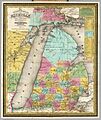
An 1835 map showing Michilimackinac County covering the Upper Peninsula and Northern Michigan.
-
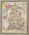
A map from 1853 showing how Michilimackinac County was divided into smaller counties as more settlers arrived.
-
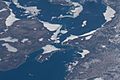
This picture, taken from the International Space Station in 2022, shows the Straits of Mackinac.
-
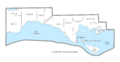
A map showing the different towns and areas within Mackinac County.
.jpg)


See also
 In Spanish: Condado de Mackinac para niños
