Naubinway, Michigan facts for kids
Quick facts for kids
Naubinway, Michigan
|
|
|---|---|

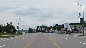
Looking east along U.S. Route 2
|
|

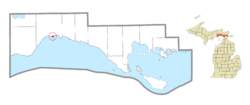
Location within Mackinac County
|
|
| Country | United States |
| State | Michigan |
| County | Mackinac |
| Township | Garfield |
| Settled | 1843 |
| Established | 1873 |
| Area | |
| • Total | 0.47 sq mi (1.22 km2) |
| • Land | 0.41 sq mi (1.07 km2) |
| • Water | 0.06 sq mi (0.15 km2) |
| Elevation | 932 ft (284 m) |
| Population
(2020)
|
|
| • Total | 147 |
| • Density | 358.54/sq mi (138.43/km2) |
| Time zone | UTC-5 (Eastern (EST)) |
| • Summer (DST) | UTC-4 (EDT) |
| ZIP code(s) |
49762
|
| Area code(s) | 906 |
| GNIS feature ID | 633624 |
| FIPS code | 26-56760 |
Naubinway (/nɒˈbɪnˈweɪ/ nah-BIN-way) is a small community in Mackinac County, Michigan. It's known as an unincorporated community and a census-designated place (CDP). This means it's a recognized place for statistics, but it doesn't have its own local government. In 2020, 147 people lived there.
Naubinway is special because it's the northernmost community right on the shores of Lake Michigan. It also has the biggest commercial fishing port in Michigan's Upper Peninsula. The community has its own post office with the ZIP Code 49762. You can find Naubinway along U.S. Route 2.
Discovering Naubinway's Past
Early Settlers and Naming the Town
The first European to settle in the Naubinway area was William Boucha in 1843. He was involved in the fur trade. He and his family built their home near Millecoquins Point. The community was first called "Bouchaville."
Later, it was renamed Naubinway. This name comes from the Ojibwe language. It means "sits and keeps watch for something" or "to look in wonderment." Some local tourist sites say it means "place of echoes."
Growth from Lumber and Fishing
Naubinway started as a lumbering community around 1880. This was when the lumber business was booming in the Upper Peninsula. Naubinway and nearby Engadine grew quickly. They became important centers for large lumber companies. At one point, about 10,000 people lived in Naubinway and the surrounding area.
In 1889, the Canadian Pacific Railway built a train line nearby. This helped a lot with sending lumber out of the area. Naubinway also benefited from being a port on Lake Michigan. Besides lumber, the community had a large commercial fishing industry. When the lumber business slowed down, fishing continued to be important.
Transportation and Historic Sites
A train depot, called Naubinway Junction, was once located north of the community. Today, the railway line is still active. It is operated by the Canadian National Railway, but trains no longer stop in Naubinway.
In the 1940s, U.S. Route 2 was built and rerouted to go right through Naubinway. This highway became a major way to travel through the area.
Because Naubinway is at the very northern tip of Lake Michigan, this spot was named a Michigan State Historic Site in 1964. It's called "the Northernmost Point of Lake Michigan." This point was important for drawing the western border of the Michigan Territory way back in 1805.
Naubinway Today
In recent years, the number of people living in Naubinway has slowly gone down. This is partly because it's a bit remote and doesn't have many big city services. Today, the community mainly relies on commercial fishing and tourism.
In 2020, Naubinway was officially listed as a census-designated place for the first time. This helps gather statistics about the area. However, Naubinway is still an unincorporated community. This means it doesn't have its own local government.
Exploring Naubinway's Geography
Location and Surroundings
Naubinway is located on the northern shores of Lake Michigan. It's part of Garfield Township in Michigan's Upper Peninsula. The community is mainly found along U.S. Route 2. This road is also known as the Lake Michigan Scenic Highway.
Naubinway is about 41 miles (66 km) west of St. Ignace. It's also about 45 miles (72 km) east of Manistique. You can find Hiawatha Trail (County Highway 40) just north of Naubinway. M-117 is to the west. Some of the land around Naubinway is part of the Lake Superior State Forest. The community sits about 932 feet (284 meters) above sea level.
Land, Water, and Nearby Places
The Naubinway area covers about 0.47 square miles (1.22 km²). Most of this is land, but about 0.06 square miles (0.15 km²) is water. U.S. Route 2 runs along the northern edge of the community.
Smaller communities nearby include Engadine and Millecoquins to the northwest. Gould City is to the west, and Garnet is to the northeast. Epoufette is to the east.
Several waterways are close to Naubinway. The Lower Millecoquins River is about a mile (1.6 km) to the west. The east and west branches of Mile Creek are about the same distance to the east. All these rivers flow into Lake Michigan.
Naubinway Harbor and Island
The southernmost tip of land in Naubinway is called Millecoquins Point. This point creates a small, natural harbor known as Naubinway Harbor. Here, you'll find a park and marina called the Naubinway–Garfield Township Marina. The Michigan Department of Natural Resources also has a public boating access site on Lake Michigan in Naubinway.
Naubinway Island is a small island about 0.63 miles (1.01 km) south of the community in Lake Michigan. The Naubinway Island Light was built on the island in 1931. This lighthouse helps guide boats and warns them about the shallow Naubinway Reef. This rocky reef is about 1.4 miles (2.3 km) south of the island. It can be very shallow, only about 4 feet (1.2 meters) deep, which can be dangerous for boats.
Local Services
Students in Naubinway and the surrounding area attend Engadine Consolidated Schools. The Naubinway post office serves the southern part of Garfield Township. It also covers a larger area to the east, including most of Hudson Township, all of Hendricks Township, and a small part of Moran Township. The Garlyn Zoo, which is located east in Hudson Township, also uses the Naubinway ZIP Code.
Naubinway's Population
Community Demographics
According to the 2020 census, the population of Naubinway was 147 people. This was the first time Naubinway was officially counted as a census-designated place.
| Historical population | |||
|---|---|---|---|
| Census | Pop. | %± | |
| 2020 | 147 | — | |
| U.S. Decennial Census | |||
 | John T. Biggers |
 | Thomas Blackshear |
 | Mark Bradford |
 | Beverly Buchanan |


