Epoufette, Michigan facts for kids
Quick facts for kids
Epoufette, Michigan
|
|
|---|---|

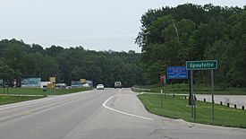
Signage looking east along U.S. Route 2
|
|
| Country | United States |
| State | Michigan |
| County | Mackinac |
| Township | Hendricks |
| Settled | 1848 |
| Established | 1881 |
| Elevation | 591 ft (180 m) |
| Time zone | UTC-5 (Eastern (EST)) |
| • Summer (DST) | UTC-4 (EDT) |
| ZIP code(s) |
49762 (Naubinway)
|
| Area code(s) | 906 |
| GNIS feature ID | 625620 |
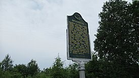
| Epoufette Informational Designation | |
|---|---|
 |
|
| Location | Roadside Park, U.S. Route 2 Naubinway, Michigan |
| Designated | July 23, 1985 |
Epoufette (/iːpoʊˈfɛt/ ee-POH-feht) is a small place in Mackinac County, Michigan. It is not a city or town with its own government. Instead, it is an unincorporated community.
Epoufette is located along the northern shore of Lake Michigan. It sits right next to U.S. Route 2. This area is part of Hendricks Township. Since it's not an official town, Epoufette does not have its own specific borders or population numbers.
Contents
History of Epoufette
The area of Epoufette was first settled around 1848. A government surveyor named John R. McLeod started an Indian village here. Early French settlers gave the place its name, Epoufette. This name means "a place of rest."
People believe the name comes from Jacques Marquette. He might have rested here when he traveled down Lake Michigan. This was almost 200 years before the village was settled.
In 1859, a fishing village was started in Epoufette. Amable Goudreau, who was from Quebec, set up a business to catch and sell fish. By 1875, this fishing village was doing very well. It was sending its fish products all over the Great Lakes.
Growth and Changes
Epoufette got its first post office in 1881. This was when the lumber industry became important in the area. John R. McLeod, who founded the village, became the first postmaster. He also worked as a fisherman and farmer. The community grew along the shores of Lake Michigan.
However, by 1893, the lumber industry started to slow down. This caused the number of people living in Epoufette to decrease. The only main business left was McLeod's general store. When railroads expanded into the Upper Peninsula, Epoufette was not on the main line. The closest train station was about 11 miles (18 km) north in Rexton.
Becoming a Resort Area
By 1909, Epoufette changed into a place for shopping and vacations. Some fishing businesses still remained. Around 1915, about 75 people lived in the community. L.A. Sweet was the postmaster and a well-known businessman. He ran a mill and a grocery store.
In 1918, Epoufette was officially called a "summer resort." New hotels started to open. At first, getting to Epoufette was hard. People used the Peter White Trail, which followed the shoreline from St. Ignace. Epoufette had a stop for stagecoaches and regular mail service. Better road access came in 1919 with the creation of M-12. In 1926, M-12 was replaced by parts of today's U.S. Route 2.
Modern Epoufette
Eventually, mail service for Epoufette moved to Naubinway. But Epoufette did have its own summer post office from 1959 to 1972. On July 23, 1985, Epoufette was named a Michigan State Historic Site. A special marker was put up in 1986. It is located along Epoufette Bay, which is now a scenic spot on U.S. Route 2.
The Epoufette Cemetery is also in the community. It is along U.S. Route 2 and Paguin Creek Road. This cemetery is still used today. Its oldest graves date back to 1887.
Geography of Epoufette
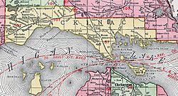
Epoufette is a small community in Hendricks Township. It is located in Michigan's Upper Peninsula. It is about 30 miles (48 km) west of the Mackinac Bridge. Epoufette is about 591 feet (180 meters) above sea level.
The community is mainly found along U.S. Route 2. It sits on the northern shore of Lake Michigan. It is about 27 miles (43 km) west of the city of St. Ignace.
Nearby Places and Features
Other communities close to Epoufette include Brevort to the southeast. Trout Lake is to the northeast. Garnet is to the northwest. Naubinway and Engadine are to the west.
Epoufette no longer has its own post office. It uses the Naubinway 49762 ZIP Code. The children in Epoufette go to Engadine Consolidated Schools. Epoufette is at the eastern edge of this school district.
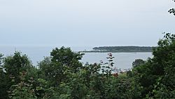
The Cut River is just east of Epoufette. The Cut River Bridge on U.S. Route 2 is a famous landmark. It is listed on the National Register of Historic Places. Epoufette is located along a small natural harbor called Epoufette Bay. The western part of the bay has a small piece of land called Point Epoufette. It sticks out into Lake Michigan. On the west side of Point Epoufette is a smaller bay called Kenyon Bay. A small, empty island called Epoufette Island is just off the southern coast of the cape.
 | DeHart Hubbard |
 | Wilma Rudolph |
 | Jesse Owens |
 | Jackie Joyner-Kersee |
 | Major Taylor |


