M-185 (Michigan highway) facts for kids
Quick facts for kids
M-185 |
||||
|---|---|---|---|---|
|
M-185 highlighted in red
|
||||
| Route information | ||||
| Maintained by MDOT | ||||
| Length | 8.004 mi (12.881 km) | |||
| Existed | 1933–present | |||
| Restrictions | Pedestrians, bicycles or horses only | |||
| Major junctions | ||||
| Loop around Mackinac Island | ||||
|
||||
| Location | ||||
| Counties: | Mackinac | |||
| Highway system | ||||
| Michigan State Trunkline Highway System Interstate • US • State (CDH)
|
||||
M-185 is a special state highway in Michigan. It circles Mackinac Island, a popular place for tourists. This island is located in Lake Huron, between Michigan's Upper and Lower peninsulas.
The road is narrow and about 8.004 miles (12.881 km) long. It offers amazing views of the water and the land. M-185 is unique because it is on an island. You can only get to it by taking a ferry boat. The city on Mackinac Island calls part of the highway "Main Street" and the rest "Lake Shore Road." M-185 goes past many important places. These include Fort Mackinac, Arch Rock, and British Landing.
The Michigan Department of Transportation (MDOT) says M-185 is the only state highway in the United States where cars are not allowed. People travel on it by walking, riding horses, in horse-drawn carriages, or by bicycle. The rule against cars started way back in 1898. Since then, only a few special vehicles, like emergency ones, have been allowed. The highway was built in the early 1900s. It became a state highway in 1933. It was paved in 1960. Parts of it were rebuilt in the 1980s because of water damage.
Contents
Exploring M-185: A Unique Highway
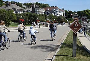
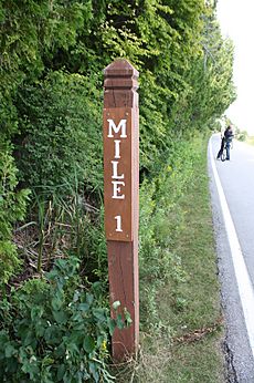
M-185 is a circular road, so it doesn't have a clear start or end. Most people consider the starting point to be at the mile 0 marker. This marker is in front of the Mackinac Island State Park Visitor Center. Instead of metal signs, the highway uses wooden mile markers. These are put up by the park, not the state transportation department.
M-185 is one of only three state highways on islands in Michigan. The others are on Drummond Island and Harsens Island. This highway is not part of the National Highway System. This system includes roads important for the country's economy and travel. Over half a million people visit M-185 every year.
Mackinac Island has been a popular place for visitors since the late 1800s. It was even the second national park in the country. Later, in 1895, it became Michigan's first state park. M-185 is famous for being the only state highway without car traffic. Many newspapers and magazines have written about its special status. In 2003, it was called the "best scenic drive" in Michigan. In 2008, USA Today named Mackinac Island one of the "10 great places to get your feet back on the ground" because it's car-free.
Starting Your Journey: Downtown Mackinac Island
The journey on M-185 usually starts and ends where Main Street meets Fort Street. This is right by the visitor center. From here, M-185 goes east. It runs between Marquette Park and the marina. The road passes by historic buildings like the Indian Dormitory and Sainte Anne's Catholic Church.
You'll also see hotels and homes. Main Street then turns northeast. It goes past Mission Point Resort. After this, the road name changes to Lake Shore Road. A path called Shoreline Trail runs next to the water here. It eventually returns to M-185 near the city's water plant.
Around the Island: Scenic Views and Landmarks
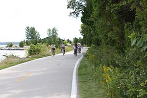
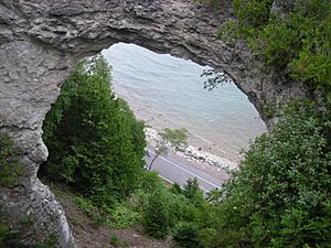
After Mission Point, M-185 continues along the eastern shore of Mackinac Island. You'll pass Dwightwood Spring. Then, you'll reach the Arch Rock viewing area, just past the mile 1 marker. The next few miles of M-185 are quiet. There aren't many big landmarks. You'll see beautiful woodlands on one side and beaches on the other.
Mile 4 is at Point aux Pins, the northernmost part of the island. Here, M-185 turns south. It passes a state boat dock and a nature center. Then, you'll arrive at British Landing. This is where British soldiers landed during the War of 1812. It's a popular spot for visitors to stop. You can find restrooms, picnic tables, and a snack stand here. M-185 continues along Maniboajo Bay. You'll pass the mile 5 marker near Radisson Point.
The next part of M-185 is also mostly undeveloped. You'll see Griffin Cove and Brown's Brook. There's a picnic area and nature trail at Brown's Brook. You'll also get great views of the Mackinac Bridge. Between mile markers 6 and 7, you'll find Devil's Kitchen. This is another popular spot for tourists. Near mile 7, there are stairs leading up to Pontiac's Lookout.
Further along, you'll see a marker about the movie Somewhere in Time. You'll also get views of the famous Grand Hotel. Its front porch is said to be the "longest in the world." You can also see Michigan's second Governor's Mansion. This is where the state's governor stays in the summer. At this point, M-185 changes back to Main Street. A boardwalk runs next to the road into the downtown area.
Back to Downtown: Shops and Ferries
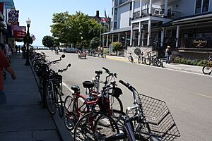
As the highway gets closer to downtown, you'll see the island's public school. Main Street then curves north through the main downtown area. Most of the city's public buildings are on Market Street, one block behind Main Street. M-185 goes through the main business district. Here, you'll find many shops, restaurants, and places to stay. Many places sell fresh Mackinac Island fudge. The ferry docks are all along Main Street in downtown. At the end of the downtown area, Main Street meets Fort Street again. This completes the circle around Mackinac Island.
History of M-185
The first rules banning cars from Mackinac Island were made on July 6, 1898. Park rules followed in 1901. People complained after a doctor's car scared horses and caused accidents. This led to the ban. The ban was even extended to "motor bicycles" in 1907. So, almost no cars or trucks are allowed on the island. Only a few emergency vehicles or special permit vehicles are seen. During winter, police sometimes use snowmobiles.
The Lake Shore Road around the island was built between 1900 and 1910. It became M-185 in 1933. Park officials asked the state to take over the road. They couldn't afford to maintain it anymore. The road was built to be used without cars. It is narrower than other state highways, about 12 feet (3.7 m) wide.
In 1960, the state paved the road with asphalt. Before that, it was made of limestone and manure. After paving, the yearly maintenance costs went down. Since the 1970s, snowmobiles have been allowed on the island in winter. In 1976, a centerline was painted on the highway for the first time.
Dealing with Lake Levels
In the mid-1980s, high water levels in Lake Huron caused problems for M-185. Waves from the lake washed over the road during a storm in 1985. This left gravel and dirt on the road. It also caused worries about erosion. MDOT spent money to install rocks and filter cloth to prevent the land from washing away. Storms later that year washed away parts of the road. MDOT closed those sections in July 1986 to fix the damage. Tourists had to use inland detours.
In 1979, a car was brought to the island for the movie Somewhere in Time. The next time a car was allowed was on July 6, 1998. This was to celebrate the 100th anniversary of the car ban. A 1901 steam-powered car toured the island. When Vice President Mike Pence visited in 2019, he had an eight-vehicle motorcade. This was a first for the island.
In 2002, MDOT received a grant to protect the land next to M-185. This allowed the park to buy rights to prevent building on private land near the road.
First Accident and Recent Updates
The only known vehicle accident on Mackinac Island happened on M-185 in 2005. The island's fire truck slightly damaged the ambulance. Both were responding to an emergency. Before this, M-185 was known as the only state highway that "never had an automobile accident."
In 2016, a Native American Cultural Trail was added along M-185. It has information panels and bike parking. Also in 2016, part of M-185 was repaved.
In late 2019, high water levels and winter storms damaged parts of the highway again. MDOT started emergency repairs. More reconstruction work began in 2020 to fix about half of the highway. This project included adding rip-rap (large rocks) to protect the road from rising lake levels. Sections of the highway were closed for this work.
In 2024, M-185 became the last state highway in Michigan to get a speed limit. The governor signed a law setting a limit of 15 miles per hour (24 km/h). This was because some e-bikes could go much faster.
Major Intersections
The entire highway is on Mackinac Island, which is in Mackinac County. Mile markers are placed going counterclockwise.
| mi | km | Destinations | Notes |
|---|---|---|---|
| 0.000 | 0.000 | Fort Street | This is the starting point for the mile markers |
| 4.552 | 7.326 | British Landing Road | This road leads to the middle of the island and British Landing |
| 7.607 | 12.242 | Market Street | This road leads to many historic places in the downtown area |
| 8.004 | 12.881 | Fort Street | This is the ending point for the mile markers, completing the loop |
| 1.000 mi = 1.609 km; 1.000 km = 0.621 mi | |||
 | William M. Jackson |
 | Juan E. Gilbert |
 | Neil deGrasse Tyson |


