Mackinac Island State Park facts for kids
Quick facts for kids Mackinac Island State Park |
|
|---|---|

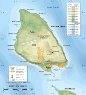
Map of Mackinac Island showing the state park boundaries
|
|
| Location | Mackinac Island, Michigan |
| Area | 2.81 sq mi (7.3 km2) |
| Established | 1875 (Mackinac National Park) 1895 (Mackinac Island State Park) |
| Governing body | Michigan Department of Natural Resources / Mackinac Island State Park Commission |
|
Mackinac Island State Park
|
|
|
U.S. National Historic Landmark District
Contributing Property |
|
| Part of | Mackinac Island (ID66000397) |
| Designated NHLDCP | October 15, 1966 |
Mackinac Island State Park is a super cool place to visit in Michigan, United States. It's located on Mackinac Island, which is a beautiful island in Lake Huron. This park covers about 80% of the entire island, which is a huge 1,800 acres (7.3 km2)!
One of the most unique things about Mackinac Island is that cars are not allowed. This means you can explore the park by bike, on foot, or even by horse-drawn carriage. The park has a special road, M-185, that goes all the way around it, and it's the only highway in Michigan where motor vehicles are banned.
Mackinac Island State Park was first created in 1875 as Mackinac National Park. It was actually the second national park ever in the U.S., right after Yellowstone National Park! Later, in 1895, it became Michigan's very first state park. Today, it's managed by the Michigan Department of Natural Resources and the Mackinac Island State Park Commission. Millions of people have visited this amazing park to see its history, cool rock formations, and beautiful nature.
Contents
A Look Back: The War of 1812
Mackinac Island played a big part in the War of 1812. This war was fought between the United States and Canada, which was a British colony at the time.
The British army built Fort Mackinac on the island during the American Revolutionary War. After that war, the fort was given to the Americans in 1796. But the British built another fort nearby on St. Joseph Island. Both countries wanted to control the waters of northern Lake Huron.
When the War of 1812 began, the British quickly captured Fort Mackinac. It stayed a British stronghold throughout the war. The Americans tried to take it back in 1814 during the Battle of Mackinac Island, but they didn't succeed. Finally, when the war ended in 1815 with the Treaty of Ghent, the island was returned to American control.
Park History: From National to State
How Mackinac Became a National Park
On March 3, 1875, the U.S. Congress officially made Mackinac Island a national park. It was the second national park in the country, following Yellowstone. A senator from Mackinac, Thomas Ferry, suggested this idea. He pointed out that soldiers already stationed on the island could also act as park caretakers. This helped convince other lawmakers. The park was then managed by the United States Department of War.
By 1888, money from leasing parts of the island helped improve the park. They built trails, fixed roads, and even put up an observation tower at Fort Holmes, the highest point on the island.
Becoming Michigan's First State Park
In 1890, the military decided Fort Mackinac was no longer important for defense. The soldiers left the island, and there was no one to look after the park. The War Department even thought about selling the park.
But people who loved the island started a campaign to save it. In September 1895, the U.S. government agreed to give the park and fort to the State of Michigan. The state then created the Mackinac Island State Park Commission. This commission was set up to manage the park, making it Michigan's very first state park!
Places to Learn: Information Centers
- Soldiers' Barracks
- Visitor Center
- Mackinac Island Tourism Bureau
Exploring Historic Sites
Important Historic Buildings

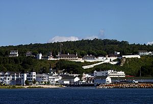
- Fort Mackinac - A museum where you can learn about the island's military past.
- Fort Holmes - Another historic fort, located at the highest point on the island.
- Mission Church - A museum showing early island life.
- Mission House
- American Fur Company Retail Store & Dr. Beaumont Museum - Learn about the fur trade and an important doctor.
- Matthew Geary House
- Benjamin Blacksmith Shop - A museum showing how blacksmiths worked.
- Biddle House - A museum about one of the island's oldest homes.
- Governor's Mansion (Lawrence Andrew Young Cottage) - The summer home for Michigan's governor.
- Richard and Jane Manoogian Mackinac Art Museum - This used to be the Indian Dormitory.
- McGulpin House - A museum.
Other Historic Spots
- Battlefield of 1814 - Where a battle took place during the War of 1812.
- British Landing - Where British troops landed in 1812.
- Cemeteries
- Lime Kiln
- Marquette Park
- Wawashkamo Golf Club
Amazing Caves and Rock Formations
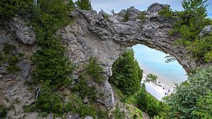
- Arch Rock - A stunning natural limestone arch.
- Gitchi Manitou
- Sugar Loaf - A tall, cone-shaped rock formation.
- Cave of the Woods
- Crack-in-the-Island
- Eagle Point Cave
- Skull Cave - A cave with a unique history.
- Friendship's Altar
- Sunset Rock (sometimes called Chimney Rock)
- Devil's Kitchen
- Robinson's Folly
Special Installations
- Anne's Tablet
Images for kids
Mackinac State Historic Parks
Mackinac State Historic Parks is a group of parks and museums managed by the Michigan Department of Natural Resources. The Mackinac Island State Park Commission leads this agency. It includes several important historical places around the Straits of Mackinac.
The main parks in this group are:
- Mackinac Island State Park, on Mackinac Island
- Fort Mackinac
- Historic Downtown Mackinac
- The Richard and Jane Manoogian Mackinac Art Museum
- Michilimackinac State Park
- Colonial Michilimackinac
- Old Mackinac Point Lighthouse
- Historic Mill Creek Discovery Park, in Mackinaw City
The Mackinac Island State Park Commission has seven members. The governor appoints these members for six-year terms, and the Michigan Senate confirms them.
 | Dorothy Vaughan |
 | Charles Henry Turner |
 | Hildrus Poindexter |
 | Henry Cecil McBay |


