Bois Blanc Island (Michigan) facts for kids
|
Native name:
Wigobiminniss
|
|
|---|---|

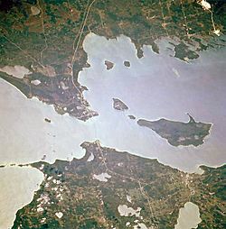
Bois Blanc Island is the largest island on the right.
|
|
|
Bois Blanc Island (Michigan)
|
|
| Geography | |
| Location | Lake Huron near the Straits of Mackinac |
| Coordinates | 45°46′30″N 84°28′44″W / 45.77500°N 84.47889°W |
| Area | 34 sq mi (88 km2) |
| Highest elevation | 692 ft (210.9 m) |
| Administration | |
| State | Michigan |
| County | Mackinac County |
| Township | Bois Blanc Township |
| Demographics | |
| Population | 100 (2020) |
Bois Blanc Island (pronounced boyz BLANK) is a beautiful island in Lake Huron. It is part of Mackinac County, Michigan. The island is about 34 square miles (88 km2) in size. It is about 12 miles (19 km) long and 6 miles (9.6 km) wide. Bois Blanc Island also has six lakes inside it. You can find it southeast of Mackinac Island. It is also almost directly north of the city of Cheboygan.
The name "Bois Blanc" comes from the French words for "white wood." People think this name refers to either the paper birch tree or, more likely, the basswood tree. The basswood's white inner bark was very useful. Native Americans and French fur traders used it. They made ropes and sewed up canoes with it. They also used it to make webbing for snowshoes. The French Canadian word for "inner bark" was "bois blanc." Native Americans also had a name for the island, Wigobiminiss. This name means the same thing: "tying bark island."
You might hear the island called "Boblo." This is an English way of saying the French name. Many islands with the same name in the Great Lakes are also called "Boblo" by local people.
Island History: A Look Back in Time
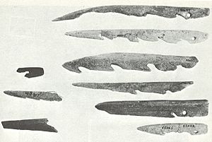
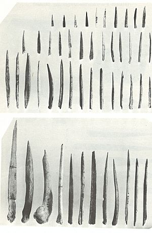
Long ago, people lived on Bois Blanc Island. Archaeologists have found many interesting things there. This place is known as the Juntunen site. They found old tools, human burials, and animal bones. These finds tell us about the people who lived on the island. They show how people lived from around 800 A.D. to 1400 A.D.
In 1795, the local Anishinaabe people, also known as Chippewa, gave Bois Blanc Island to the U.S. government. This happened as part of the Treaty of Greenville. The treaty gave the U.S. government many important areas. Bois Blanc Island was described as "an extra and voluntary gift" from the Chippewa nation.
During the War of 1812, U.S. Navy Captain Arthur Sinclair's ships hid near the island. They were waiting to attack the British at Fort Mackinac. Later, in 1880, a person named Henry English was caught on the island. He was wanted by authorities in Pennsylvania. Agents from the Pinkerton Agency found him there. He was later sent back to Pennsylvania.
In 1827, the United States officially mapped the island. In 1890, the United States Life Saving Service built a station there. This station helped rescue people from shipwrecks. Later, in the late 1800s, Bois Blanc became a popular summer resort community. People used to get lime and firewood from the island. These were used for Mackinac Island and other nearby settlements.
Bois Blanc Island has a lot of Lake Huron shoreline. It also has two connected fishing lakes inside the island. These are called Twin Lakes. Much of the island is state-owned forest land. It has tall White and Norway pine trees. Some of these trees are 200 feet (61 m) tall. Even in the 1950s, Bois Blanc provided wood to Mackinac Island. Cutting wood is not allowed on Mackinac Island.
Bois Blanc Island did not have electricity until 1964. That year, a company installed a long underwater cable. This cable brought power from the mainland to the island. In 1999, the electric service was updated. Two new cables were placed across the Straits of Mackinac.
Getting Around Bois Blanc Island
You can bring your car or other vehicles to Bois Blanc Island by ferry. There are no paved roads on the island. However, there is a main county road. It goes from the northeast part of the island to the far western tip. Fire Tower Road goes through the middle of the island. It is also the way to get to Twin Lakes and Lake Thompson. These are the island's biggest inland lakes. There are also many other unmaintained roads and trails.
Plaunt Transportation is the only company that offers ferry services. Ferries sail every day when the water is not frozen. They travel from Cheboygan to Pointe Aux Pins on the island. The ferry boat, named Kristen D, can carry 16 vehicles.
The island also has its own airport, Bois Blanc Island Airport. It has a paved runway. Its airport code is 6Y1.
During some winters, when the straits freeze, an ice road is created. Evergreen trees are used to mark the path. This allows people to travel over the ice between the island and the mainland. The ice road usually goes from Pries Landing on the mainland to Sand Bay on Bois Blanc.
 | Jessica Watkins |
 | Robert Henry Lawrence Jr. |
 | Mae Jemison |
 | Sian Proctor |
 | Guion Bluford |


