
Treaty of Greenville facts for kids
| Treaty with the Wyandots, etc. | |
|---|---|

First page of the Treaty of Greenville
|
|
| Context | Northwest Indian War |
| Location | Fort Greenville |
| Negotiators | [United States Western Confederacy |
| Language | English |
The Treaty of Greenville was an important agreement signed in 1795 between the United States and several Native American nations. It was officially called the Treaty with the Wyandots, etc. This treaty helped set new borders between lands belonging to Native American peoples and areas where European American settlers could live.
It was signed on August 3, 1795, at Fort Greenville, which is now the town of Greenville, Ohio. This happened about a year after Native American forces lost the Battle of Fallen Timbers. The treaty officially ended the Northwest Indian War in the Ohio Country. It also limited Native American lands to northwestern Ohio and started a system of yearly payments for land that was given up. The main groups involved were a group of Native American tribes called the Western Confederacy and the United States government. General Anthony Wayne and local frontiersmen represented the U.S. government.
This treaty became a symbol for the end of the frontier in the part of the Northwest Territory that would later become the state of Ohio.
Contents
Who Signed the Treaty?

General "Mad Anthony" Wayne led the American group. He was famous for his victory at the Battle of Fallen Timbers. Other important Americans included William Wells, William Henry Harrison, William Clark, Caleb Swan, and Meriwether Lewis.
Many Native American leaders signed the treaty. They came from tribes like the Wyandot (including chiefs Tarhe, Roundhead, and Leatherlips), Delaware, Shawnee (like chiefs Blue Jacket and Black Hoof), Ottawa, Chippewa, and Potawatomi. Other tribes included the Miami (with leaders like Jean Baptiste Richardville and Little Turtle), Wea, Kickapoo, and Kaskaskia.
After their defeat at Fallen Timbers, General Wayne tried to get some key Native American leaders to support peace. Blue Jacket, a Shawnee war chief, encouraged others to agree to Wayne's terms. Tarhe even said that the American victory showed that the Great Spirit favored the United States.
However, Little Turtle, a Miami chief, was against the treaty. He had actually advised against fighting Wayne at Fallen Timbers. For a week, Wayne pushed the tribes to accept peace based on earlier treaties. But Little Turtle argued that the Miami tribe had not been part of those treaties and would not accept them. He said those treaties were not valid because they were made with people who did not own the land they sold.
Wayne then shared important news: the U.S. Senate had just approved the Jay Treaty. This meant that Great Britain would no longer help the Native Americans. Tarhe warned his fellow leaders that Wayne had enough military power to take all their lands if they did not negotiate. Little Turtle and the Miami tribe were the only ones still disagreeing.
In a private meeting, Wayne told Little Turtle that he was going against the wishes of most of the tribes. Little Turtle finally signed, but he said he would be the last to sign and the last to break the treaty, even though he disagreed with its terms.
The day after the treaty was signed, Little Turtle's wife passed away. U.S. soldiers carried her to her grave and gave her a special three-gun salute.
President George Washington signed the treaty, and the United States Senate approved it on December 22, 1795.
What the Treaty Said
The Treaty of Greenville had ten main parts, called articles.
Land and Yearly Payments
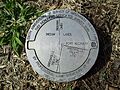
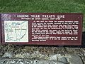
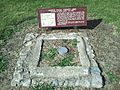
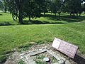
The treaty created a border known as the Greenville Treaty Line. For many years, this line separated Native American territory from lands where European-American settlers could live. However, settlers often moved onto Native American lands anyway.
In exchange for giving up large parts of what is now Ohio, the Native American tribes received goods worth $20,000. These goods included blankets, tools, and farm animals.
The treaty also started a system of "annuity" payments. This meant the U.S. government would give yearly payments of money and supplies, like calico cloth, to the Native American tribes. This system gave the government more influence over tribal matters.
The Treaty Line

The treaty changed some parts of the borders that had been set by earlier agreements. The new line covered areas in Ohio where settlements already existed. This included areas like the Western Reserve and the line of forts built by General Wayne. The new border made sure that about two-thirds of the Ohio Country was considered "Whiteman's land."
The treaty line started at the mouth of the Cuyahoga River in what is now Cleveland. It went south along the river to a carrying path (a "portage") between the Cuyahoga and Tuscarawas Rivers. This area is now known as the Portage Lakes. The line continued down the Tuscarawas River to Fort Laurens, near Bolivar.
From there, the line went west-southwest to near Fort Loramie on a branch of the Great Miami River. Then it went west-northwest to Fort Recovery on the Wabash River, near the border of Ohio and Indiana. Finally, from Fort Recovery, the line went south-southwest to the Ohio River. This point was across from the mouth of the Kentucky River in Carrollton, Kentucky. Rufus Putnam, a surveyor appointed by George Washington, measured and marked this treaty line.
Other Land Areas
The treaty also included other important areas. These were places like Fort Miamis and other forts in Indiana, Michigan, and Ohio. The British had agreed to give these forts to the United States in the 1783 Treaty of Paris, but they had not left yet. In Indiana, there were also areas like the Vincennes Tract and Clark's Grant.
The treaty also allowed the U.S. Army to keep posts and special land areas within Native American territory. One very important area was the future site of Fort Dearborn (now Downtown Chicago) on Lake Michigan. Other American lands inside Native American territory included Fort Detroit, Ouiatenon, Fort Wayne, and Fort Sandusky.
The treaty also made sure that existing settlements like Vincennes, Clark's Grant, and various French settlements were not given up.
Other Rules
The United States gave up all claims to Native American lands that were not inside the treaty line in Ohio or the special areas mentioned. The Native American groups agreed to recognize the United States as the main power in the whole territory. However, the local peoples could still use their own lands freely as long as they were friendly to American settlers. The treaty also arranged for trading prisoners and explained who would be in charge of keeping the border and punishing those who broke the rules.
Criticism of the Treaty
After the treaty was signed, some Native American leaders who supported peace were criticized. One strong critic was the Shawnee chief Tecumseh. He said that the "peace chiefs" had given away land that they did not truly own. Because of this, Tecumseh later fought against the Americans during the War of 1812. He was finally defeated in 1813.
What Happened Next?
.jpg)
The peace created by the treaty did not last forever. Settlers kept moving onto Native American lands, especially in Indiana. This made Tecumseh, who had not signed the Treaty of Greenville, very upset. Over the next ten years, he worked to bring the tribes together again at Prophetstown.
The growing tension led to the Battle of Tippecanoe in 1811. This was a big defeat for Native American nations and may have led them to side with the British in the War of 1812.
The Treaty of Greenville marked the end of the frontier in the Northwest Territory. After this, the U.S. government began buying Native American lands through treaties and moving tribes by law. This process was briefly stopped by the War of 1812. By the 1840s, most Native American peoples had been moved west of the Mississippi River to reservations in what is now Oklahoma. Future conflicts would happen mostly west of the Mississippi.
The treaty line also became the southwestern border of the Northwest Territory when it was divided in 1800. When Ohio became a state in 1803, a small piece of land called "The Gore" was left over. This land became part of Indiana Territory and later Dearborn County.
Among the people who signed the treaty were Meriwether Lewis and William Clark. They met for the first time here and later led the famous Lewis and Clark Expedition in 1804. This expedition explored and claimed the Louisiana Purchase for the United States. Also, William Henry Harrison, another signer, later became the 9th President of the United States in 1841.
Fort Greenville was left empty in 1796. It took another 12 years before the town of Greenville, Ohio was founded on the same spot.
This was the last treaty signed by General Wayne. He passed away just over a year later, in December 1796.
Art About the Treaty
A large painting that celebrates the treaty hangs in the Ohio Statehouse. It was created by Ohio artist Howard Chandler Christy. At 23 feet wide, it is the biggest painting in the Ohio Statehouse.
Images for kids
-
-
-
-
-
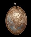
Treaty of Greenville medal


