
Dearborn County, Indiana facts for kids
Quick facts for kids
Dearborn County
|
|
|---|---|
.jpg)
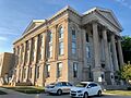
Dearborn County Courthouse
|
|

Location within the U.S. state of Indiana
|
|
 Indiana's location within the U.S. |
|
| Country | |
| State | |
| Founded | 1803 |
| Named for | Dr. Henry Dearborn |
| Seat | Lawrenceburg |
| Largest city | Lawrenceburg |
| Area | |
| • Total | 307.42 sq mi (796.2 km2) |
| • Land | 305.03 sq mi (790.0 km2) |
| • Water | 2.38 sq mi (6.2 km2) 0.77%% |
| Population
(2020)
|
|
| • Total | 50,679 |
| • Estimate
(2023)
|
51,215 |
| • Density | 164.853/sq mi (63.6500/km2) |
| Demonym(s) | Dearbornian |
| Time zone | UTC−5 (Eastern) |
| • Summer (DST) | UTC−4 (EDT) |
| Congressional district | 6th |
| Indiana county number 15 | |

Dearborn County is one of the 92 counties in the state of Indiana. It's located in the southeast corner of Indiana, right next to the Ohio border. Dearborn County was created in 1803. It was formed from a piece of land that used to be part of Hamilton County, Ohio.
In 2020, about 50,679 people lived here. The main town and biggest city is Lawrenceburg. Dearborn County is also part of the larger Cincinnati, OH-KY-IN Metropolitan Statistical Area. This means it's connected to the big city of Cincinnati.
Contents
History of Dearborn County
In 1803, Ohio became a state. After this, a small, wedge-shaped piece of land was given to Indiana Territory. This land was then organized and became Dearborn County. It was named after Henry Dearborn, who was the U.S. Secretary of War at that time. Lawrenceburg was chosen as the county seat, which is like the main administrative town.
Over the years, parts of Dearborn County were used to create seven other counties. The current borders of Dearborn County were set in 1845. This area, sometimes called the "Gore," includes parts of several present-day counties. These are Franklin, Ohio, Randolph, Switzerland, Union, Wayne, and Fayette counties. The first counties to be formed from Dearborn were Franklin and Wayne in 1811. Switzerland County followed in 1814.
Early on, Lawrenceburg was a very important town. It became a key spot for railroads, connecting two major train lines. There was a friendly competition between Lawrenceburg and another town called Rising Sun. Many German-speaking immigrants lived in Rising Sun. They wanted their town to be the county seat. To solve this, in 1844, the Indiana State government made a new county. They took the southern part of Dearborn County and created Ohio County. Rising Sun became the county seat for this new, smaller county on March 1, 1844.
Geography of Dearborn County
Dearborn County covers about 307.42 square miles. Most of this area, about 305.03 square miles, is land. The rest, about 2.38 square miles, is water. The famous Ohio River forms part of the county's southeastern border.
Main Cities
Smaller Towns
Other Communities
These are smaller places that are not officially cities or towns.
- Bright (a census-designated place)
- Hidden Valley (a census-designated place)
- Bonnell
- Braysville
- Chesterville
- Cochran
- Cold Springs
- Dover
- Farmers Retreat
- Guilford
- Hardinsburg
- Hubbells Corner
- Kyle
- Lawrenceville
- Logan
- Manchester
- Mount Sinai
- New Alsace
- Sparta
- Weisburg
- Wilmington
- Wrights Corner
- Yorkville
Local Divisions (Townships)
Counties in Indiana are divided into smaller areas called townships.
- Caesar Creek
- Center
- Clay
- Harrison
- Hogan
- Jackson
- Kelso
- Lawrenceburg
- Logan
- Manchester
- Miller
- Sparta
- Washington
- York
Neighboring Areas
Dearborn County shares its borders with these other counties:
- Franklin County (to the north)
- Butler County, Ohio (to the northeast)
- Hamilton County, Ohio (to the east)
- Boone County, Kentucky (to the southeast)
- Ohio County (to the south)
- Ripley County (to the west)
Weather in Dearborn County
The weather in Lawrenceburg changes throughout the year. In January, the average low temperature is about 21°F (-6°C). In July, the average high temperature is about 86°F (30°C). The coldest temperature ever recorded was -27°F (-33°C) in January 1994. The hottest was 107°F (42°C) in July 1988.
The amount of rain and snow also changes. September usually has the least amount of rain, about 2.94 inches. May usually has the most, with about 5.53 inches.
| Weather chart for Lawrenceburg, Indiana | |||||||||||||||||||||||||||||||||||||||||||||||
|---|---|---|---|---|---|---|---|---|---|---|---|---|---|---|---|---|---|---|---|---|---|---|---|---|---|---|---|---|---|---|---|---|---|---|---|---|---|---|---|---|---|---|---|---|---|---|---|
| J | F | M | A | M | J | J | A | S | O | N | D | ||||||||||||||||||||||||||||||||||||
|
3.5
38
21
|
3
44
24
|
4.4
54
31
|
4.4
64
39
|
5.5
74
49
|
4.6
82
58
|
4.6
86
63
|
4
85
62
|
2.9
79
55
|
3.2
67
43
|
3.8
55
35
|
3.7
43
26
|
||||||||||||||||||||||||||||||||||||
| temperatures in °F precipitation totals in inches source: The Weather Channel |
|||||||||||||||||||||||||||||||||||||||||||||||
|
Metric conversion
|
|||||||||||||||||||||||||||||||||||||||||||||||
Who Lives Here? (Demographics)
| Historical population | |||
|---|---|---|---|
| Census | Pop. | %± | |
| 1810 | 7,310 | — | |
| 1820 | 11,468 | 56.9% | |
| 1830 | 13,974 | 21.9% | |
| 1840 | 19,327 | 38.3% | |
| 1850 | 20,166 | 4.3% | |
| 1860 | 24,406 | 21.0% | |
| 1870 | 24,116 | −1.2% | |
| 1880 | 26,671 | 10.6% | |
| 1890 | 23,364 | −12.4% | |
| 1900 | 22,194 | −5.0% | |
| 1910 | 21,396 | −3.6% | |
| 1920 | 20,033 | −6.4% | |
| 1930 | 21,056 | 5.1% | |
| 1940 | 23,053 | 9.5% | |
| 1950 | 25,141 | 9.1% | |
| 1960 | 28,674 | 14.1% | |
| 1970 | 29,430 | 2.6% | |
| 1980 | 34,291 | 16.5% | |
| 1990 | 38,835 | 13.3% | |
| 2000 | 46,109 | 18.7% | |
| 2010 | 50,047 | 8.5% | |
| 2020 | 50,679 | 1.3% | |
| 2023 (est.) | 51,215 | 2.3% | |
| U.S. Decennial Census 1790-1960 1900-1990 1990-2000 2010-2013 |
|||
In 2010, there were 50,047 people living in Dearborn County. These people lived in 18,743 homes, and 13,773 of these were families. On average, about 164 people lived in each square mile. There were also about 20,171 housing units, like houses or apartments.
Most people in the county, about 97.5%, were white. Smaller groups included Black or African American (0.6%), Asian (0.4%), and American Indian (0.2%). About 1.0% of the people were from two or more races. People of Hispanic or Latino background made up 1.0% of the population.
When it comes to where people's families originally came from, many had German roots (46.5%). Others had Irish (19.2%), English (11.4%), or American (7.8%) ancestry.
About 35.1% of homes had children under 18 living there. Most homes (58.5%) were married couples living together. The average age of people in the county was 40 years old.
The average income for a household was $47,697. For families, the average income was $66,561. About 7.2% of all people in the county lived below the poverty line. This included 8.5% of kids under 18.
2020 Census Information
The 2020 census showed these numbers for Dearborn County's population:
| Race | Number | Percentage |
|---|---|---|
| White (not Hispanic) | 47,319 | 93.37% |
| Black or African American (not Hispanic) | 292 | 0.6% |
| Native American (not Hispanic) | 66 | 0.13% |
| Asian (not Hispanic) | 211 | 0.42% |
| Pacific Islander (not Hispanic) | 9 | 0.02% |
| Other/Mixed (not Hispanic) | 2,058 | 4.06% |
| Hispanic or Latino | 724 | 1.43% |
How to Get Around (Infrastructure)
Dearborn County has several important roads that help people travel.
 Interstate 74
 Interstate 275
 U.S. Route 50
 U.S. Route 52
 State Road 1
 State Road 46
 State Road 48
 State Road 56
 State Road 62
 State Road 148
 State Road 262
 State Road 350
Famous People from Dearborn County
- Nick Goepper – A professional slopestyle skier who has won three Olympic medals.
- Erwin "Cannonball" Baker – A famous motorcycle and auto racer. He was added to the Motorsports Hall of Fame of America in 1989.
- John Whiteaker – The first state Governor of Oregon (from 1859 to 1862). He also served as Oregon's Congressman.
- Jim Lyttle – A professional baseball player.
- Lonnie Mack – An important guitar player in early rock 'n' roll music.
- Louis Skidmore – An architect who helped start the famous architecture firm Skidmore, Owings & Merrill.
Images for kids
-
Dearborn County Courthouse
See also
 In Spanish: Condado de Dearborn para niños
