
Ohio County, Indiana facts for kids
Quick facts for kids
Ohio County
|
|
|---|---|
.jpg)
Ohio County Courthouse in Rising Sun
|
|

Location within the U.S. state of Indiana
|
|
 Indiana's location within the U.S. |
|
| Country | |
| State | |
| Founded | 1844 |
| Named for | Ohio River |
| Seat | Rising Sun |
| Largest city | Rising Sun |
| Area | |
| • Total | 87.43 sq mi (226.4 km2) |
| • Land | 86.14 sq mi (223.1 km2) |
| • Water | 1.29 sq mi (3.3 km2) 1.48%% |
| Population
(2020)
|
|
| • Total | 5,940 |
| • Estimate
(2023)
|
6,004 |
| • Density | 67.94/sq mi (26.232/km2) |
| Time zone | UTC−5 (Eastern) |
| • Summer (DST) | UTC−4 (EDT) |
| Congressional district | 6th |
| Indiana county number 58 FIPS County Code 115 Smallest county in Indiana in area Least populated county in Indiana |
|
Ohio County is a small county in southeastern Indiana. In 2020, about 5,940 people lived there. It is the smallest county in Indiana by land area, covering only 87 square miles. It also has the fewest people of all Indiana counties.
The main town and county seat is Rising Sun. This is the only official town in the county. Ohio County was created in 1844. It was one of the last counties to be formed in Indiana. The county is named after the Ohio River, which forms its eastern border. This river also separates Ohio County from the state of Kentucky. Ohio County is part of the larger Cincinnati, Ohio-Kentucky-Indiana metropolitan area. The county is divided into four smaller areas called townships, which help provide local services.
Contents
History of Ohio County
Ohio County was formed from parts of Dearborn County. This happened on January 4, 1844. The county was created to solve a disagreement about where the county seat should be. People in Rising Sun and Lawrenceburg both wanted to be the main town. So, Ohio County was made, with Rising Sun as its seat. It was named after the Ohio River, which is a very important river in the area.
The Ohio County courthouse was built in Rising Sun in 1845. It is a two-story brick building. It has a classic Greek Revival style with large pillars at the front. This courthouse is still used today. It is the oldest courthouse in Indiana that has been used continuously.
Geography and Nature
Ohio County covers a total area of about 87.43 square miles. Most of this area, about 86.14 square miles, is land. The rest, about 1.29 square miles, is water.

Neighboring Counties
Ohio County shares borders with these other counties:
- Boone County, Kentucky – to the east, across the Ohio River
- Dearborn County – to the north
- Ripley County – to the northwest
- Switzerland County – to the south
Towns and Communities
Main Town
- Rising Sun – This is the only official town in the county. It is located right on the banks of the Ohio River.
Smaller Communities
Many smaller, unincorporated communities are also found in Ohio County:
- Aberdeen
- Bascom Corner
- Bear Branch
- Blue
- Buffalo
- Camp Shore
- Cofield Corner
- Downey Corner
- Hartford
- Milton
- North Landing
County Townships
Ohio County is divided into four townships:
- Cass
- Pike
- Randolph
- Union
Transportation Routes
Highways and Roads
Several state roads help people travel through Ohio County:
- US Route 50 passes close to the county's northern border in Dearborn County.
- State Road 56 comes from Switzerland County in the south. It goes through Rising Sun and continues north along the Ohio River into Dearborn County.
- State Road 156 also runs along the Ohio River. It enters the southeast part of Ohio County and connects with State Road 56.
- State Road 262 enters from Dillsboro and crosses the county, ending in Rising Sun.
Railroads
Currently, there are no active railroad lines in Ohio County.
Education in Ohio County
Ohio County has two schools that are part of one school system. The Ohio County Elementary–Middle School serves younger students. Rising Sun High School is for older students. In the 2009–2010 school year, the elementary-middle school had 636 students. The high school had 264 students.
Residents of Ohio County can use the Ohio County Public Library. It has one branch located in Rising Sun.
Climate and Weather Patterns
| Weather chart for Rising Sun, Indiana | |||||||||||||||||||||||||||||||||||||||||||||||
|---|---|---|---|---|---|---|---|---|---|---|---|---|---|---|---|---|---|---|---|---|---|---|---|---|---|---|---|---|---|---|---|---|---|---|---|---|---|---|---|---|---|---|---|---|---|---|---|
| J | F | M | A | M | J | J | A | S | O | N | D | ||||||||||||||||||||||||||||||||||||
|
3.1
39
21
|
3
45
24
|
4.1
55
32
|
4.2
66
41
|
4.7
75
51
|
4.8
83
60
|
3.9
87
65
|
3.8
86
63
|
3.1
79
56
|
2.9
68
43
|
3.5
56
35
|
3.4
44
26
|
||||||||||||||||||||||||||||||||||||
| temperatures in °F precipitation totals in inches source: The Weather Channel |
|||||||||||||||||||||||||||||||||||||||||||||||
|
Metric conversion
|
|||||||||||||||||||||||||||||||||||||||||||||||
The weather in Rising Sun changes throughout the year. In January, the average low temperature is about 21°F. In July, the average high temperature is about 87°F. The coldest temperature ever recorded was -23°F in January 1994. The hottest was 104°F in July 1988.
The amount of rain and snow also varies. October usually has the least precipitation, about 2.92 inches. June typically has the most, around 4.83 inches.
Population and People
| Historical population | |||
|---|---|---|---|
| Census | Pop. | %± | |
| 1850 | 5,308 | — | |
| 1860 | 5,462 | 2.9% | |
| 1870 | 5,837 | 6.9% | |
| 1880 | 5,563 | −4.7% | |
| 1890 | 4,955 | −10.9% | |
| 1900 | 4,724 | −4.7% | |
| 1910 | 4,329 | −8.4% | |
| 1920 | 4,024 | −7.0% | |
| 1930 | 3,747 | −6.9% | |
| 1940 | 3,782 | 0.9% | |
| 1950 | 4,223 | 11.7% | |
| 1960 | 4,165 | −1.4% | |
| 1970 | 4,289 | 3.0% | |
| 1980 | 5,114 | 19.2% | |
| 1990 | 5,315 | 3.9% | |
| 2000 | 5,623 | 5.8% | |
| 2010 | 6,128 | 9.0% | |
| 2020 | 5,940 | −3.1% | |
| 2023 (est.) | 6,004 | −2.0% | |
| U.S. Decennial Census 1790-1960 1900-1990 1990-2000 2010-2017 |
|||
In 2010, Ohio County had 6,128 people living there. Most of the people were white (98.1%). Smaller groups included Black or African American (0.4%), Asian (0.3%), and American Indian (0.2%). About 1.1% of the population was of Hispanic or Latino background.
Many families live in Ohio County. In 2010, about 28.7% of households had children under 18. The average age of people in the county was 43.7 years old.
Images for kids
-
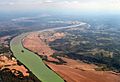
Rising Sun, on the Ohio River.

See also
 In Spanish: Condado de Ohio (Indiana) para niños
