Chesterville, Indiana facts for kids
Quick facts for kids
Chesterville
|
|
|---|---|
| Country | United States |
| State | Indiana |
| County | Dearborn |
| Township | Sparta |
| Elevation | 876 ft (267 m) |
| ZIP code |
47032
|
| FIPS code | 18-12430 |
| GNIS feature ID | 432459 |
Chesterville is a small, quiet place in Indiana, United States. It's known as an unincorporated community. This means it's a group of homes and businesses that isn't officially a town or city with its own local government. Instead, it's part of a larger area called Sparta Township in Dearborn County.
Where is Chesterville Located?
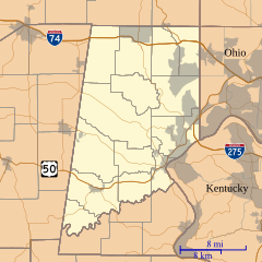
Chesterville is found in the southeastern part of Indiana. It sits within Dearborn County, which is close to the border with Ohio and Kentucky. The community is located at a height of about 876 feet (267 meters) above sea level. Its exact location can be pinpointed using geographic coordinates: 39°04′04″N latitude and 85°03′08″W longitude.
A Glimpse into Chesterville's Past
Chesterville has a short but interesting history, especially concerning its communication services. A post office was opened in Chesterville in 1884. A post office is a place where people can send and receive mail, buy stamps, and sometimes even handle other services. This was an important connection for the community to the outside world. However, the post office in Chesterville didn't stay open forever. It closed down in 1907.
 | Jackie Robinson |
 | Jack Johnson |
 | Althea Gibson |
 | Arthur Ashe |
 | Muhammad Ali |


